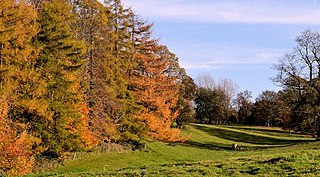
Drumsloe

Last updated

Drumsloe
Drumsloe Townland - geograph.org.uk - 345496.jpg
United Kingdom Northern Ireland adm location map.svg
Red pog.svg
Drumsloe
Location within Northern Ireland
District
County
Country Northern Ireland
Sovereign state United Kingdom
Postcode district BT94 2.
Dialling code 028
Police Northern Ireland
Fire Northern Ireland
Ambulance Northern Ireland
UK Parliament
NI Assembly
List of places
UK
Northern Ireland
Fermanagh
54°15′N7°20′W / 54.25°N 7.34°W / 54.25; -7.34

Drumsloe, Northern Ireland is a locality and townland in the Barony of Tirkennedy just east of Ballinamallard township in Magheracross. Drumsloe is 240.77 acres in area. [1]

Contents

Drumsloe Drumsloe - geograph.org.uk - 345507.jpg
Drumsloe

History

Drumsloe is known as early as 1609AD when it was known as Dromslo, a name that may be from Druim Sluagh meaning ridge of the hosts. [2] The Griffith's Valuation of 1863 indicates a school was located in Drumsloe. Significant landmarks include drumsloe lough, where illegal distillery on Drumsloe Island was operated for some time in the early 19th century. [3]

Religion

Religion has played a large part in the History of Drumsloe. About 450AD the local parish was said to have been founded by St Patrick and about 550AD St Columba passed through the area. In 1769 John Wesley visited the district bringing Methodism and nearby Coa Chapel was built in 1770. In the early 20th century further religious movements swept the district. [4] [5]

Related Research Articles

<span class="mw-page-title-main">County Fermanagh</span> County in Northern Ireland

County Fermanagh is one of the thirty-two counties of Ireland, one of the nine counties of Ulster and one of six counties of Northern Ireland

<span class="mw-page-title-main">Cookstown</span> Town in County Tyrone, Northern Ireland

Cookstown is a town in County Tyrone, Northern Ireland. It is the fourth largest town in the county and had a population of 12,546 in the 2021 census. It, along with Magherafelt and Dungannon, is one of the main towns in the Mid-Ulster council area. It was founded around 1620 when the townlands in the area were leased by an English ecclesiastical lawyer, Dr. Alan Cooke, from the Archbishop of Armagh, who had been granted the lands after the Flight of the Earls during the Plantation of Ulster. It was one of the main centres of the linen industry west of the River Bann, and until 1956, the processes of flax spinning, weaving, bleaching and beetling were carried out in the town.

<span class="mw-page-title-main">Kilkeel</span> Human settlement in Northern Ireland

Kilkeel is a small town, civil parish and townland in County Down, Northern Ireland. It is the southernmost town in Northern Ireland. It lies within the historic barony of Mourne. Kilkeel town is the main fishing port on the Down coast, and its harbour is home to the largest fishing fleet in Northern Ireland. It had a population of 6,633 people at the 2021 census. The town contains the ruins of a 14th-century church and fort, winding streets and terraced shops. It lies just south of the Mourne Mountains.

<span class="mw-page-title-main">Draperstown</span> Village in County Londonderry, Northern Ireland

Draperstown is a village in the Sperrin Mountains in County Londonderry, Northern Ireland. It is situated in the civil parish of Ballinascreen and is part of Mid-Ulster district. It is also part of the Church of Ireland parish of Ballynascreen and the Catholic parish of Ballinascreen, and within the former barony of Loughinsholin.

<span class="mw-page-title-main">Templemore</span> Town in County Tipperary, Ireland

Templemore is a town in County Tipperary, Ireland. It is a civil parish in the historical barony of Eliogarty. It is part of the parish of Templemore, Clonmore and Killea in the Roman Catholic Archdiocese of Cashel and Emly.

<span class="mw-page-title-main">Dromore, County Tyrone</span> Human settlement in Northern Ireland

Dromore is a town, townland and civil parish in County Tyrone, Northern Ireland. It is nine miles (14 km) south west of Omagh on the A32 and sixteen miles (26 km) from Enniskillen. The population of Dromore was 1,198 at the 2011 Census.

A townland is a small geographical division of land, historically and currently used in Ireland and in the Western Isles in Scotland, typically covering 100–500 acres (40–202 ha). The townland system is of Gaelic origin, antedating the Norman invasion, and most have names of Irish origin. However, some townland names and boundaries come from Norman manors, plantation divisions, or later creations of the Ordnance Survey. The total number of inhabited townlands in Ireland was 60,679 in 1911. The total number recognised by the Irish Place Names database as of 2014 was 61,098, including uninhabited townlands, mainly small islands.
<span class="mw-page-title-main">Ballymena</span> Town in County Antrim, Northern Ireland

Ballymena is a town in County Antrim, Northern Ireland. It had a population of 31,205 people at the 2021 Census, making it the seventh largest town in Northern Ireland by population. It is part of the Borough of Mid and East Antrim.

<span class="mw-page-title-main">Islandmagee</span> Human settlement in Northern Ireland

Islandmagee is a peninsula and civil parish on the east coast of County Antrim, Northern Ireland, located between the towns of Larne and Whitehead. It is part of the Mid and East Antrim Borough Council area and is a sparsely populated rural community with a long history since the mesolithic period. The population is approximately 2,500. In the early medieval period it was known as Semne, a petty-kingdom within Ulaid.

<span class="mw-page-title-main">Ballinamallard</span> Village in County Fermanagh, Northern Ireland

Ballinamallard or Bellanamallard is a small village and townland in County Fermanagh, Northern Ireland. It had a population of 1,364 people in the 2021 Census. It lies to the north of Enniskillen and is within Fermanagh and Omagh district.
<span class="mw-page-title-main">Donaghmore, County Tyrone</span> Place

Donaghmore is a village, townland and civil parish in County Tyrone, Northern Ireland, about five kilometres (3 mi) north-west of Dungannon. In the 2011 Census it had a population of 1,122 people. The village is beside the River Torrent, formerly known as the Torrent Flow.

<span class="mw-page-title-main">Clady, County Tyrone</span> Village and townland in County Tyrone, Northern Ireland

Clady is a small village and townland in County Tyrone, Northern Ireland. It lies about 4 miles from Strabane on the River Finn and borders the Republic of Ireland. In the 2011 Census it had a population of 538 people. It is within Urney civil parish and the former barony of Strabane Lower. In local government it is part of the Derry City and Strabane District Council. The townland covers an area of 173 acres.

<span class="mw-page-title-main">Cill Ghallagáin</span> Village in County Mayo, Ireland

Cill Ghallagáin is a small Gaeltacht coastal townland and village in the northwest corner of Kilcommon Parish, County Mayo, Republic of Ireland, an area of 345 hectares in size. Off the northern coast of this townland lies Kid Island, an island of 13 hectares rising on steep cliffs to a height of 95 metres (311 ft) above sea level. The island is used for grazing sheep in the summer months. Kilcommon Parish consists of two peninsulas – Dún Chaocháin and Dún Chiortáin, to the west.

<span class="mw-page-title-main">Aughanduff</span> Village in Ulster, Northern Ireland

Aughanduff is a small village and townland in the civil parish of Forkhill, in the former barony of Orior Upper, and County of Armagh, Northern Ireland. The townland is roughly co-existent with Upper and Lower Aughanduff Mountains, both of which form part of the Ring of Gullion geological formation, which has been described as the most spectacular example of a ring-dyke intrusion in Ireland or Britain, and was the first ring dyke in the world to be geologically mapped. Aughanduff has been populated since prehistoric times and has been recorded as a distinct district since at least the early 1600s. The area's history is both well documented and reflects its location both in rural Ireland and on the borderlands of the Pale, the Plantation of Ulster, and latterly Northern Ireland; indeed, part of the district's northern boundary was proposed for forming part of the northern border of the Irish Free State by the Irish Boundary Commission in its final report of 1925. The Boundary Commission's report was never implemented and today, the area remains within Northern Ireland, some five miles from the border with the Republic of Ireland. Part of the area has been designated by the Northern Ireland Environment Agency as an Area of Special Scientific Interest, and the district lies within the Ring of Gullion Area of Outstanding Natural Beauty.

<span class="mw-page-title-main">St Johnston, County Donegal</span> Village in County Donegal, Ireland

St Johnston, officially Saint Johnstown, is a village, townland, and an electoral division in County Donegal, Ireland. It is in the Laggan district of East Donegal on the left bank of the River Foyle. It is in the civil parish of Taughboyne and barony of Raphoe North, on the R236 (Lifford–Newtowncunningham) road where it overlaps the R265 (Carrigans–Raphoe) road. The village is about 12 kilometres (7.5 mi) south of Derry.

<span class="mw-page-title-main">Magheracross</span>

Magheracross is a townland and civil parish in County Fermanagh, Northern Ireland. It extends in area from just north of Enniskillen to the border with County Tyrone. There is also a small enclave in County Tyrone.

<span class="mw-page-title-main">Coa, Northern Ireland</span> Human settlement in Northern Ireland

Coa is a townland and hamlet in Magheracross civil parish, County Fermanagh, Northern Ireland. It is located east of the town of Ballinamallard and is 399.11 acres in area. Landmarks include St Marys Church Coa, Cavanalough Glebe, and Killee Lough.

<span class="mw-page-title-main">Salloon, County Fermanagh</span> Locality in Northern Ireland

Salloon is a locality and townland in Magheracross civil parish, County Fermanagh, Northern Ireland. Salloon is in the Barony of Tirkennedy and is 222.08 acres in area. A large townland, Salloon takes in large areas of rural farmland but also includes about a third of the township of Ballinamallard.

<span class="mw-page-title-main">Sidaire</span> Administrative area in County Fermanagh, Northern Ireland

Sidaire is a townland in Magheracross civil parish, County Fermanagh, Northern Ireland. It is located in the barony of Tirkennedy, in civil parish of Magheracross.

<span class="mw-page-title-main">Saint John's Point, County Down</span> Cape on the coast of Ireland

Saint John's Point or St. John's Point is a cape at the southern tip of the Lecale peninsula of County Down, Northern Ireland, separating Dundrum Bay from Killough Harbour, which forms its northern extremity. The cape is mostly surrounded by the Irish Sea and derives its name from a now ruined church dedicated to Saint John, being recorded here since at least 1170. A well-known beacon in the north-eastern Irish Sea, St. John's Point Lighthouse, built in 1844, sits near its southern tip and, at 40 m (130 ft), is the tallest lighthouse in Ireland.

References

  1. Drumsloe Townland Information.
  2. Drumsloe place name.
  3. Ballinamallard History.
  4. "The Pilgrim Tramps. The Rite of Baptism. Immersion of 27 Followers in the Ballinamallard River" The Impartial Reporter and Farmers Journal, Enniskillin, Northern Ireland. 29 September 1904, p. 8.
  5. "Crowds Await Millennium. Cooneyites Hold Prayer Meetings and Baptize Hundreds Daily in Ireland" The New York Times , New York, New York. 4 August 1909, p. 3.