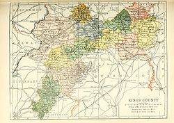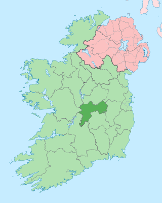
County Offaly is a county in Ireland. It is part of the Eastern and Midland Region and the province of Leinster. It is named after the ancient Kingdom of Uí Failghe. It was formerly known as King's County, in honour of Philip II of Spain. Offaly County Council is the local authority for the county. The county population was 82,668 at the 2022 census.
Templemore is a town in County Tipperary, Ireland. It is a civil parish in the historical barony of Eliogarty. It is part of the parish of Templemore, Clonmore and Killea in the Roman Catholic Archdiocese of Cashel and Emly.

Tullamore is the county town of County Offaly in Ireland. It is on the Grand Canal, in the middle of the county, and is the fourth most populous town in the midlands region, with 14,607 inhabitants at the 2016 census.

Clara is a town on the River Brosna in County Offaly and is the 10th largest town in the midlands of Ireland. The town had a population of 3,336 as of the 2016 census. Clara's local services include churches, banks, credit union, schools, supermarkets, shops, garages, pubs, nightclubs and restaurants. It has its own Garda (police) and fire station while the Midlands Regional Hospital is located approximately eleven kilometres away in Tullamore.

Kilcormac is a small town in County Offaly, Ireland, located on the N52 at its junction with the R437 regional road, between the towns of Tullamore and Birr. It is a small town of 935 people, many of whom were previously employed by Bord na Móna to work the local peat bogs. The town is located near the Slieve Bloom Mountains. The Silver River flows through the town. The town was more commonly referred to as Frankford prior to Irish independence.
Carra is one of the nine baronies of County Mayo in Ireland, located in the mid-south area of the county. It is sometimes known as Burriscarra. It incorporates the town of Castlebar, the villages of Tourmakeady, Belcarra and Turlough, where the National Museum of Country Life is situated.

Eglish is a small village in County Tyrone, Northern Ireland. It is about 6 km southwest of Dungannon, in the Mid Ulster District Council area. In the 2001 Census it had a population of 93. The village has grown in a dispersed form and has a mix of housing, industry and services.

Ballyboy or Ballaboy is a village in County Offaly, Ireland. It is about two kilometres east of Kilcormac.

Rahan is a parish and village in County Offaly, Ireland. It is associated with Mochuda. The village is located on the banks of the river Clodagh approximately 8 km from Tullamore. The parish of Rahan extends from The Island near Ballycumber in the north to Mucklagh in the south.

Tiranny is a barony in County Armagh, Northern Ireland. It lies on the western boundary of the county, bordering County Tyrone to its west and County Monaghan in the Republic of Ireland to its south. It is bordered by three other baronies in Northern Ireland: Dungannon Lower and Dungannon Upper to the north-west; and Armagh to the east. It also borders two baronies in the Republic of Ireland; Cremorne to the south and Trough to the west.

Farran is a village in County Cork, Ireland, in the parish of Ovens. It lies on the southside of the River Lee. Farran is 12 miles (19 km) west from Cork City on the N22 road.
Lorrha is a small village at the northern tip of County Tipperary, Ireland. It is located on a minor road between the R489 Birr to Portumna road and the N65 Nenagh to Portumna road about five kilometres east of the point where the River Shannon enters Lough Derg.
Middle Third is a barony in County Tipperary, Ireland. This geographical unit of land is one of 12 baronies in County Tipperary. Its chief town is Cashel. The barony lies between Eliogarty to the north, Iffa and Offa East to the south, Clanwilliam to the west and Slievardagh to the east. It is currently administered by Tipperary County Council.

Lurg is a barony situated in the north of County Fermanagh, Northern Ireland. To its south lies Lower Lough Erne, and it is bordered by four other baronies in Northern Ireland: Magheraboy to the south; Tirkennedy to the south-east; Omagh West to the north; and Omagh East to the east. It also borders to the west the barony of Tirhugh in the Republic of Ireland.
Rath is a hamlet in the south west area of County Offaly, Ireland. The hamlet is located midway between the towns of Birr and Kilcormac on a northeast-southwest country road. It is located in the parish of Eglish and Drumcullen which is in the Roman Catholic Diocese of Meath. The hamlet has a number of local amenities for the local population including a church, a national school, a local community centre and a local shop. Drumcullen GAA is the local GAA club and is located about half a kilometre to the south of the hamlet.
Firceall was an ancient Gaelic Irish territory which formed the most south - westerly part of the ancient Kingdom of Meath. O'Molloy was chieftain of the territory. Firceall itself comprised the ancient baronies of Ballycowan, Ballyboy and Eglish, which are located in modern day mid County Offaly extending from Durrow north of Tullamore to Eglish on the edge of Birr in an area which is some 25 miles in length by 5 miles in width. The name Firceall comes from the Irish words Fir Ceala meaning Men of the Churches.

Saint Gobhan has long been linked with the parish of Seagoe – recorded for instance as Teach dho-Ghobha – in County Armagh, Ireland.

Ballycowan or Ballycowen is a barony in County Offaly, Ireland.
Durrow is a civil parish in County Offaly, Ireland. It is located about 5.52 kilometres (3 mi) north–north–west of Tullamore.
Kilmanaghan is a civil parish which spans the counties of Offaly and Westmeath in Ireland. It is located about 27.76 kilometres (17 mi) south–west of Mullingar and 17.52 kilometres (11 mi) north–west of Tullamore.