Moycullen Maigh Cuilinn (Irish) | |
---|---|
![]() Harbour at Muckanaghederdauhaulia | |
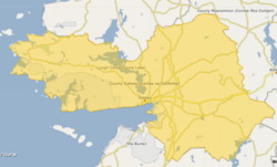
![]() Barony map of County Galway, 1900; Moycullen is in the west, coloured yellow. | |
Coordinates: 53°20′N9°34′W / 53.33°N 9.57°W | |
Sovereign state | Ireland |
Province | Connacht |
County | Galway |
Area | |
• Total | 819.0 km2 (316.2 sq mi) |
Moycullen (Irish : Maigh Cuilinn) is a historical barony in west County Galway, Ireland. [1]
Baronies were mainly cadastral rather than administrative units. They acquired modest local taxation and spending functions in the 19th century before being superseded by the Local Government (Ireland) Act 1898. [2]
The name is from the village of Moycullen, which name means "plain of holly" or "plain of (Saint) Uillinn." [3] This was the site of the chief castle of the O'Flaherty, now in ruins. [4]
In the Gaelic Irish era, the territory of Delbhna Tír Dhá Locha roughly corresponds to the barony of Moycullen; it was ruled by the Mac Con Raoi (MacConroys). In the 11th century the Ó Flaithbheartaigh (O'Flaherty) were pushed westward and took over the area, becoming lords of Moycullen and Iar Connacht. [5] [6]
Moycullen barony was created before 1574. [7]
Moycullen is in the west of the county, on the north coast of Galway Bay, and to the west of Lough Corrib and Galway City. It is a large barony, incorporating part of the Connemara region. [8] It is chiefly composed of pasture and bog, with several forests in the centre and many lakes dotted around the barony. [9]
Settlements within the historical barony of Moycullen include: [10]