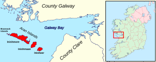
The Aran Islands or The Arans are a group of three islands at the mouth of Galway Bay, off the west coast of Ireland, with a total area around 46 km2 (18 sq mi). They constitute the historic barony of Aran in County Galway.

Dalkey is an affluent suburb of Dublin, and a seaside resort southeast of the city, and the town of Dún Laoghaire, in the county of Dún Laoghaire–Rathdown in the traditional County Dublin, Ireland. It was founded as a Viking settlement and became an active port during the Middle Ages. According to chronicler John Clyn (c.1286–c.1349), it was one of the ports through which the plague entered Ireland in the mid-14th century. In modern times, Dalkey has become a seaside suburb that attracts some tourist visitors.

Rail transport in Ireland is provided by Iarnród Éireann in the Republic of Ireland and by Northern Ireland Railways in Northern Ireland.

Connemara is a region on the Atlantic coast of western County Galway, in the west of Ireland. The area has a strong association with traditional Irish culture and contains much of the Connacht Irish-speaking Gaeltacht, which is a key part of the identity of the region and is the largest Gaeltacht in the country. Historically, Connemara was part of the territory of Iar Connacht. Geographically, it has many mountains, peninsulas, coves, islands and small lakes. Connemara National Park is in the northwest. It is mostly rural and its largest settlement is Clifden.
Boyle is a town in County Roscommon, Ireland. It is located at the foot of the Curlew Mountains near Lough Key in the north of the county. Carrowkeel Megalithic Cemetery, the Drumanone Dolmen and the lakes of Lough Arrow and Lough Gara are also close by. As of 2016, the population of the town was 2,568.

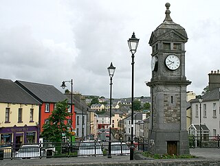
Clifden is a coastal town in County Galway, Ireland, in the region of Connemara, located on the Owenglin River where it flows into Clifden Bay. As the largest town in the region, it is often referred to as "the Capital of Connemara". Frequented by tourists, Clifden is linked to Galway city by the N59.

Spiddal, also known as Spiddle, is a village on the shore of Galway Bay in County Galway, Ireland. It is 18 kilometres (11 mi) west of Galway city, on the R336 road. It is on the eastern side of the county's Gaeltacht and of the Connemara region. According to the 2022 census, approximately 75% of the population are Irish-speaking and, of these, approximately 40% speak Irish on a daily basis outside the education system. It is a centre for tourism with a beach, harbour, and shore fishing. The village is part of the civil parish of Moycullen.
Carraroe is a village in Connemara, the coastal Irish-speaking region (Gaeltacht) of County Galway, Ireland. It is known for its traditional fishing boats, the Galway Hookers. Its population is widely dispersed over the Carraroe peninsula between Cuan an Fhir Mhóir and Cuan Chasla. Carraroe has an unusual beach, Trá an Dóilín, a biogenic gravel beach made of coralline algae known as "maerl".

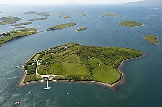
Omey Island is a tidal island situated near Claddaghduff on the western edge of Connemara in County Galway, Ireland. From the mainland the island is almost hidden. It is possible to drive or walk across a large sandy strand to the island by following the arrowed signs. At high tide, the water is deep enough to cover a car.

Bere Island or Bear Island is an island in Bantry Bay off the Beara Peninsula in County Cork, Ireland. It spans roughly 10 km x 3 km, with an area of 17.68 km² and, as of the 2022 census, had a population of 218 people.

Inishbofin is a small island off the coast of Connemara, County Galway, Ireland. Inishbofin has around 180 inhabitants and is a tourist destination.

Letterfrack or Letterfrac is a small village in the Connemara area of County Galway, Ireland. It was founded by Quakers in the mid-19th century. The village is south-east of Renvyle peninsula and 15 kilometres north-east of Clifden on Barnaderg Bay and lies at the head of Ballinakill harbour. Letterfrack contains the visitors centre for Connemara National Park.

Inisheer is the smallest and most easterly of the three Aran Islands in Galway Bay, Ireland. With 343 residents as of the 2022 census, it is second-most populous of the Arans. Caomhán of Inis Oírr is the island's patron saint. There are five small settlements: Baile Thiar, Chapeltown, Castle Village, Baile an Fhormna and Baile an Lorgain.
Lettermullen,, is a small island and village on the coast of southern Connemara in County Galway, Ireland. It is about 58 km (36 mi) west of Galway city, at the far western end of Galway Bay, Lettermullen is the westernmost of three islands; Lettermullen, Gorumna and Lettermore, along with smaller islands collectively known as Ceantar na nOileán connected to the mainland by the bridges and causeways of R374.

Dundrum is a village in County Tipperary, Ireland. In the 2016 census, the population was 165. It is in the barony of Kilnamanagh Lower.
Inish Turk Beg is a private island in Clew Bay, County Mayo on the west coast of Ireland. Between 2003 and 2013, it was owned by Nadim Sadek, an Irish-Egyptian marketing entrepreneur. The island is approximately 10 km (6.2 mi) by road from the towns of Newport and Westport, County Mayo, and 67 km (42 mi) from Ireland West Airport Knock.
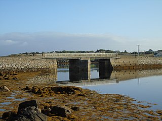
The R374 road is a regional road in County Galway, Ireland. It connects various islands in Connemara, the Gaeltacht part of the county.
Ceantar na nOileán is an Irish-speaking district in the West of County Galway. There are about 2,000 people living in the area, located 56 km west of Galway city.
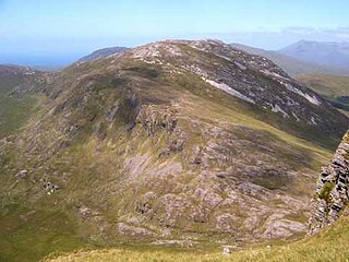
Benbrack at 582 metres (1,909 ft), is the 251st–highest peak in Ireland on the Arderin scale; while it does not have the elevation to be a Vandeleur-Lynam, it has the prominence to rank as a Marilyn. Benbrack is situated on its own small massif to the north of the core Twelve Bens mountain range in the Connemara National Park in County Galway, Ireland. It is the 10th-tallest of the core Twelve Bens, and is linked by a deep col to Muckanaght, which is itself attached by a high ridge to the tallest mountain of the Twelve Bens range, Benbaun at 729 metres (2,392 ft).

The Galway to Clifden Railway or Connemara Railway was a railway line opened in Ireland by the Midland Great Western Railway (MGWR) in 1895. It led from Galway to Clifden, the chief town of the sparsely populated Connemara region in western County Galway. It was closed by the MGWR's successor, the Great Southern Railways (GSR) in 1935.

