Glenamaddy

Last updated

Glenamaddy
Gleann na Madadh (Irish)
Town
IMG Glenamaddy2751.jpg
Glenamaddy
Ireland adm location map.svg
Red pog.svg
Glenamaddy
Location in Ireland
Coordinates: 53°36′22″N8°33′36″W / 53.606°N 8.560°W / 53.606; -8.560
Country Ireland
Province Connacht
County County Galway
Elevation
87 m (285 ft)
Population
 (2022) [1]
557
Irish Grid Reference M627620

Glenamaddy, or Glennamaddy (Irish : Gleann na Madadh), [2] is a small town in County Galway, Ireland. It lies at the crossroads where the R362 and R364 regional roads meet. Glenamaddy became a musical focal point in Connacht during the 1960s during the showband era.[ citation needed ]

Contents

To the east of the town lies Loch Lurgeen, a raised bog. The origins of the parish lie in the village of Boyounagh, which lies to the northwest of Glenamaddy.

Name

It is unclear what the exact meaning and Irish translation for Glenamaddy is. It could be derived from the Irish Gleann na Madadh, [2] Gleann meaning glen [3] (valley) and madhadh from madra meaning dog. This would suggest that the name means Valley of the Dogs. This name could have originated from the shape of the Glenamaddy Turlough as looked at from above.

Glenamaddy might also have come from Gleann na Maighe Duibhí or Valley of the Black Plain, [4] presumably because of the turlough lake in the area which dries up every year leaving behind a black plain of limestone.

History

Glenamaddy was located in what was the medieval kingdom of Uí Díarmata, ruled by the O Concannon dynasty.

The town itself did not develop until the 1820s when a church was built and regular markets began in the town. From this time on, the town began to grow and shops and pubs were built around the square and on the four roads leading into the town.[ citation needed ] These "four roads" are reflected in a song of the same name. [5] In 1853, a workhouse was built on the Creggs road.

In 1904, St. Patrick's church was built to replace the older church which was in the grounds of where the town graveyard stands today. In 1909, St. Bridget's Town Hall was built. In 1924, a mill was built in Leitra and gave employment in the area. Other local historic sites include a megalithic tomb at Ballinastack and a crannóg on Kiltullagh lake.[ citation needed ]

In the early 20th century, markets were common in the town as for some small cottage industries it was the main outlet for their wares. Cattle, pigs, sheep, animal feeds, and household supplies were all sold at these markets and large crowds gathered in the town on these days.

Crossroads in Glenamaddy Cross roads, Glenamaddy - geograph.org.uk - 1265004.jpg
Crossroads in Glenamaddy

In the 21st century, Glenamaddy has some decline, including with the loss of its Bank of Ireland and Ulster Bank branches in 2006 and 2013 respectively.[ citation needed ] As of 2015, the town had reportedly lost over 120 of its young people to emigration. [5] In the ten years between the 2006 and the 2016 census of Ireland, the population of Glenamaddy decreased by four percent, from 500 to 480 people. [6]

Esker Mass Rock

During penal times (17th and 18th centuries), a priest would travel to Esker to celebrate mass at the site of a local mass rock. On one occasion, around the 1790s, a priest was celebrating mass at Esker. An informer had notified the authorities that the priest would be there. Although scouts were positioned along the hilltops, they didn't see the military authorities because they were dressed as common people and mingled among the crowd. As soon as the priest arrived, he was captured and was given a mock trial.[ citation needed ] He was hanged from a tree which is now called Sceach na gCloigeann (white thorn tree of the heads).[ citation needed ] The valley in which this occurred is known as Gleann an tSagairt (the priest's valley). A bell was found in a nearby field some years later.[ citation needed ] A brass cross was also found with no base, which had been painted black to prevent reflection of sunlight. For the year 2000 millennium celebrations, Mass was celebrated at the mass rock.[ citation needed ]

Culture

The Esker Ballroom was once one of the most popular dance venues in the country.[ citation needed ] Built in 1947 on the Kilkerrin Road in Glenamaddy, the ballroom initially failed to get a license to hold dances or operate a bar.[ citation needed ] Eventually, in April 1949, the first dance was held in the ballroom. Further dances were held every second Sunday.[ citation needed ] In 1970, the Esker Ballroom closed as marquees, who were in direct competition with the ballroom, became more popular in the area. The building was sold and a night club was opened in its place.[ citation needed ]

The song "Four Country Roads", which mentions Glenamaddy, [5] was a hit for Big Tom in Ireland in 1981. [7]

Education

Glenamaddy Community School was founded in 2002 by the Sisters of Mercy and County Galway VEC following the amalgamation of Coláiste Seosaimh and St. Benin's Vocational School.[ citation needed ]

Sport

Glenamaddy C.L.G. is the local Gaelic Athletic Association club and plays Gaelic football. [8] Glen Celtic is the local soccer club.[ citation needed ]

Notable people

Related Research Articles

<span class="mw-page-title-main">Glen</span> Name for valley commonly used in Ireland, Scotland and the Isle of Man

A glen is a valley, typically one that is long and bounded by gently sloped concave sides, unlike a ravine, which is deep and bounded by steep slopes. The word is Goidelic in origin: gleann in Irish and Scottish Gaelic, glion in Manx. The designation "glen" also occurs often in place names. Glens are appreciated by tourists for their tranquility and scenery.

<span class="mw-page-title-main">Glengarriff</span> Tourist village in County Cork, Ireland

Glengarriff is a village of approximately 140 people on the N71 national secondary road in the Beara Peninsula of County Cork, Ireland. Known internationally as a tourism venue, it has a number of natural attractions. It sits at the northern head of Glengarriff Bay, a smaller enclave of Bantry Bay.

<span class="mw-page-title-main">Kinvara</span> Village in south County Galway, Ireland

Kinvara or Kinvarra is a sea port village in the southwest of County Galway, Ireland. It is located in the civil parish of Kinvarradoorus in the north of the barony of Kiltartan. Kinvarra is also an electoral division.

<span class="mw-page-title-main">Carran</span> Village in County Clare, Ireland

Carran, also Carron, is a small village in County Clare, Ireland. It is in the Burren region, within a civil parish of the same name. It is notable mainly for being the birthplace of Michael Cusack, the inspirer and co-founder of the Gaelic Athletic Association. At the time of the 2011 Census, Carran had 106 inhabitants.

<span class="mw-page-title-main">Strokestown</span> Town in County Roscommon, Ireland

Strokestown, also known as Bellanamullia and Bellanamully, is a small town in County Roscommon, Ireland. It is one of the 27 designated Heritage Towns in Ireland. Located in the part of the country marketed for tourism purposes as Ireland's Hidden Heartlands, it is 140 km (87 mi) from Dublin and 120 km (75 mi) from Galway. Strokestown is one of Ireland's few planned towns, showing evidence of deliberate planning, such as formally aligned streets and prominent public buildings.

<span class="mw-page-title-main">Spiddal</span> Village in Connemara, Ireland

Spiddal, also known as Spiddle, is a village on the shore of Galway Bay in County Galway, Ireland. It is 18 kilometres (11 mi) west of Galway city, on the R336 road. It is on the eastern side of the county's Gaeltacht and of the Connemara region. According to the 2022 census, approximately 75% of the population are Irish-speaking and, of these, approximately 40% speak Irish on a daily basis outside the education system. It is a centre for tourism with a beach, harbour, and shore fishing. The village is part of the civil parish of Moycullen.

<span class="mw-page-title-main">Abbeyfeale</span> Town in County Limerick, Ireland

Abbeyfeale is a historic market town in County Limerick, Ireland, near the border with County Kerry. The town is on the N21 road from Limerick to Tralee, some 21 kilometres south-west of Newcastle West and 16 kilometres south-east of Listowel and 38 kilometres north-east of Tralee. The town is in a civil parish of the same name.

<span class="mw-page-title-main">Clara, County Offaly</span> Town in County Offaly, Ireland

Clara is a town on the River Brosna in County Offaly, Ireland. It is the 10th largest town in the midlands of Ireland. The town had a population of 3,403 as of the 2022 census.

<span class="mw-page-title-main">Ballyfarnon</span> Village in County Roscommon, Ireland

Ballyfarnon is a village in northern County Roscommon, Ireland. Built on the River Feorish at the foot of Arigna Mountain, it lies between Loughs Skean and Meelagh with Lough Arrow, Lough Allen, Lough Bo and Lough-na-Sool nearby. It lies on the Sligo/Leitrim R284 regional road on the border with County Sligo.

<span class="mw-page-title-main">Rosmuc</span> Village in County Galway, Ireland

Rosmuc or Ros Muc, sometimes anglicised as Rosmuck, is a village in the Conamara Gaeltacht of County Galway, Ireland. It lies halfway between the town of Clifden and the city of Galway. Irish is the predominant spoken language in the area, with the electoral division of Turlough, Rosmuc, representing one of the highest percentages of Irish-speaking people in the country. The townland of Rosmuck is part of the civil parish of Kilcummin.

<span class="mw-page-title-main">Salthill</span> Suburb of Galway City, Ireland

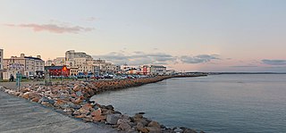
Salthill is a seaside area in the city of Galway in the west of Ireland. Lying within the townland of Lenaboy, it attracts tourists all year round. There is a 2 km long promenade, locally known as the Prom, which overlooks Galway Bay and has several bars, restaurants and hotels.

<span class="mw-page-title-main">Corofin, County Galway</span> Village in County Galway, Ireland

Corofin or Corrofin is a village and parish in County Galway, Ireland, situated on the N17 road between Galway City and Tuam.

Annaghdown GAC is a Gaelic Athletic Association club based in County Galway, Ireland. The club is a member of the Galway GAA and was founded in 1887. Underage teams in both hurling and football play in the Galway league and championships. Annaghdown are a dual club and cater for Gaelic football, hurling and Ladies football. There was a camogie club in the parish in times past when Corrandrum fielded a team, but the ladies of the parish now play camogie with Carnmore, Turloughmore or Castlegar clubs.

Kilkerrin-Clonberne is a Gaelic Athletic Association club based in Clonberne, County Galway, Ireland.

<span class="mw-page-title-main">Kilkerrin</span>

Kilkerrin is a village in County Galway, Ireland. It is situated on the R364 regional road 6 km south of the town of Glenamaddy. Features in the area include Kiltullagh Lake and the Lough Lurgeen raised bog.

<span class="mw-page-title-main">Glinsk, County Galway</span> Glinsk, County Galway, Ireland

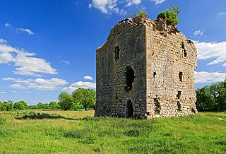
Glinsk is a small village in County Galway, Ireland, between Creggs and Ballymoe. Glinsk is located approximately 68 km from Galway city and approximately 30 km from Roscommon. It is located in valley of the River Suck, which has a 60-mile hiking trail. Nearby is the Glinsk Castle ruin, built by Ulick Burke in the early 17th century. Also in the area is the ruins of Ballynakill Abbey, which dates from the early 13th century. See Burke Baronets.

<span class="mw-page-title-main">Castlehaven</span> Civil parish in County Cork, Ireland

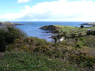
Castlehaven is a civil parish in County Cork, Ireland. It is located in West Cork, approximately 45 miles south-west of Cork City on the coast. The civil parish includes the town of Castletownshend and the hamlets of Rineen and Tragumna. The area's Gaelic football club, Castlehaven GAA, has claimed several Munster Senior Club Football Championship titles.

All Saints Gaelic Athletic Club is the only Gaelic Athletic Association club in the town of Ballymena, County Antrim. The club is a member of the South-West Antrim division of Antrim GAA, and competes in Gaelic football, hurling, Ladies Gaelic football and camogie.

<span class="mw-page-title-main">Glin, County Limerick</span> Village in County Limerick, Ireland

Glin is a village in the northwest of County Limerick, Ireland. It is on the south shore of the River Shannon's estuary, on the N69 road between Foynes and Tarbert. The population of the village at the 2022 census was 644.

John Geraghty is an Irish former Gaelic footballer who played at club level with Kilkerrin, Mountbellew–Moylough and Fr Griffin's and at inter-county level with the Galway senior football team. He usually lined out as a goalkeeper.

References

  1. "Profile 1 - Population Distribution and Movement F1015 - Population: Glenamaddy, Co. Galway". Central Statistics Office (Ireland) . Retrieved 21 July 2023.
  2. 1 2 "Gleann na Madadh / Glennamaddy". logainm.ie. Placenames Database of Ireland. Retrieved 22 February 2023.
  3. "Glenamaddy - Galway County Heritage Office". Galway County Heritage Office. Galway City Council. 22 February 2015. Retrieved 2 September 2017.
  4. "Glenamaddy // Kilkerrin (Co. Galway / North)". Ireland Byways. Retrieved 2 September 2017.
  5. 1 2 3 McCormack, Clare (1 March 2015). "Failing rural towns: Eerie silence falls on famed town of the 'Four Roads'". Irish Independent . Retrieved 1 March 2015.
  6. "Glenamaddy (Ireland) Census Town". City Population. Retrieved 22 February 2023.
  7. "Search - Title - Four Country Roads". irishcharts.ie. Irish Recorded Music Association. Archived from the original on 22 February 2023.
  8. "The History of Glenamaddy GAA". Glenamaddy GAA Club. Retrieved 2 September 2017.
  9. McManus, John (27 June 2014). "Luck, timing and a few master strokes key to Comer brothers' success". irishtimes.com. Irish Times. Retrieved 14 May 2017.
  10. Gaughan, J. Anthony (2009). "Mee, Jeremiah". dib.ie. Dictionary of Irish Biography. doi:10.3318/dib.005783.v1 . Retrieved 29 May 2023.