
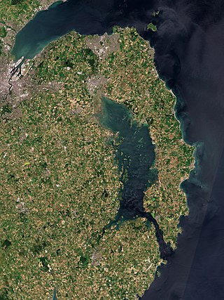
County Donegal is a county of Ireland in the province of Ulster and in the Northern and Western Region. It is named after the town of Donegal in the south of the county. It has also been known as County Tyrconnell or Tirconaill, after the historic territory. Donegal County Council is the local council and Lifford is the county town.
Strangford Lough is a large sea lough or inlet in County Down, in the east of Northern Ireland. It is the largest inlet in Ireland and the wider British Isles, covering 150 km2 (58 sq mi). The lough is almost fully enclosed by the Ards Peninsula and is linked to the Irish Sea by a long narrow channel at its southeastern edge. The main body of the lough has at least seventy islands along with many islets (pladdies), bays, coves, headlands and mudflats. It is part of the Strangford and Lecale Area of Outstanding Natural Beauty. Strangford Lough was designated as Northern Ireland's first Marine Conservation Zone in 2013, and has been designated a Special Area of Conservation for its important wildlife.

Portaferry is a small town in County Down, Northern Ireland, at the southern end of the Ards Peninsula, near the Narrows at the entrance to Strangford Lough. It is home to the Exploris aquarium and is well known for the annual Gala Week Float Parade. It hosts its own small Marina, the Portaferry Marina. The Portaferry – Strangford Ferry service operates daily at 30-minute intervals between the villages of Portaferry and Strangford, less than 1500 metres apart, conveying about 500,000 passengers per annum. It had a population of 2,514 people in the 2011 Census. The town is located within the Barony of Ards Upper.

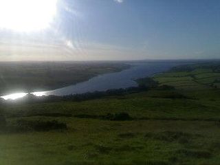
Turlough Hill, also known as Tomaneena, is a 681-metre-high (2,234 ft) mountain in County Wicklow in Ireland and site of Ireland's only pumped-storage hydroelectricity plant. The power station is owned and operated by the ESB and can generate up to 292 megawatts (392,000 hp) of electricity at times of peak demand.

The Wicklow Mountains form the largest continuous upland area in Ireland. They occupy the whole centre of County Wicklow and stretch outside its borders into the counties of Dublin, Wexford and Carlow. Where the mountains extend into County Dublin, they are known locally as the Dublin Mountains. The highest peak is Lugnaquilla at 925 metres.
Coole Park is a nature reserve of approximately 1,000 acres (4 km2) located a few miles west of Gort, County Galway, Ireland. It is managed by the Irish National Parks & Wildlife Service, part of the Department of Arts, Heritage and the Gaeltacht. The park is in a low–lying karstic limestone area characterised by seasonal lakes, known as turloughs, which are almost unique to Ireland. It has extensive woodlands. There are 6 kilometres of signposted nature trails plus a formal late 18th century walled garden.

Lough Derg, historically Lough Dergart, is a freshwater lake in the Shannon River Basin, Ireland. It is the third-biggest on the island of Ireland and the second largest lake in the Republic of Ireland.

Killarney National Park, near the town of Killarney, County Kerry, was the first national park in Ireland, created when the Muckross Estate was donated to the Irish Free State in 1932. The park has since been substantially expanded and encompasses over 102.89 km2 of diverse ecology, including the Lakes of Killarney, oak and yew woodlands of international importance, and mountain peaks. It has the only red deer herd on mainland Ireland and the most extensive covering of native forest remaining in Ireland. The park is of high ecological value because of the quality, diversity, and extensiveness of many of its habitats and the wide variety of species that they accommodate, some of which are rare. The park was designated a UNESCO Biosphere Reserve in 1981. The park forms part of a Special Area of Conservation and a Special Protection Area.
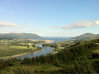
Carlingford Lough is a glacial fjord or sea inlet in northeastern Ireland, forming part of the border between Northern Ireland to the north and the Republic of Ireland to the south. On its northern shore is County Down, the Mourne Mountains, and the town of Warrenpoint; on its southern shore is County Louth, the Cooley Mountains and the village of Carlingford. The Newry River flows into the loch from the northwest.
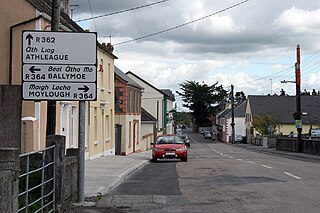
Glenamaddy, or Glennamaddy, is a small town in County Galway, Ireland. It lies at the crossroads where the R362 and R364 regional roads meet. Glenamaddy became a musical focal point in Connacht during the 1960s during the showband era.

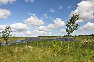
A turlough is a seasonal or periodic water body found mostly in limestone karst areas of Ireland, west of the River Shannon. The name comes from the Irish tur, meaning "dry", and loch, meaning "lake". The water bodies fill and empty with the changes in the level of the water table, usually being very low or empty during summer and autumn and full in the winter. As groundwater levels drop the water drains away underground through cracks in the karstic limestone.
Lough Derravaragh is a lake in County Westmeath, Ireland, north of Mullingar between Castlepollard, Crookedwood and Multyfarnham.

Lough Oughter is a lake, or complex of lakes, in County Cavan covering more than 8,900 hectares. The complex of lakes lies on the River Erne, and forms the southern part of the Lough Erne complex. The lakes are bounded roughly by Belturbet in the north, Cavan town to the east, Crossdoney to the south and Killeshandra to the west.

The National Museum of Ireland – Country Life is located in Turlough village, 8 km (5.0 mi) northeast of Castlebar, County Mayo, Ireland. Established in 2001, the museum is part of the National Museum of Ireland and is the only national museum outside Dublin. The museum exhibits the way of life of rural Irish people between 1850 and 1950, and is in the grounds of Turlough Park House. There are displays about the home, the natural environment, trades and crafts, communities, and working on the land and on water.
Boora Bog is a cutaway peat bog situated in County Offaly, Ireland. Peat was harvested for fuel between the 1950s and 1970s, and the land is now being reclaimed for agricultural and eco-tourism use. There was a lake called Lough Boora, which was drained by Bord na Móna, but was not used for peat production: this area is now maintained as a nature reserve by the Irish Wildlife Trust. There are two angling lakes.
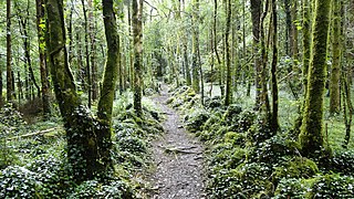
Dromore, County Clare is a rural townland in County Clare in the Republic of Ireland. It is located in the parish of Ruan and was formerly the location of Dromore House. Today, most of the townland is accounted for by Dromore Wood Nature Reserve. It is open to the public and also contains the ruins of Dromore Castle.
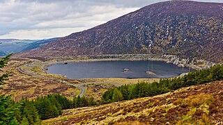
The Turlough Hill Power Station is a pumped storage power station in Ireland, owned and operated by the Electricity Supply Board (ESB).
Callows are a type of wetland found in Ireland. They are a seasonally flooded grassland ecosystem found on low-lying river floodplains.

The Lung is a river in Ireland flowing through counties Mayo and Roscommon. It runs in a generally north-easterly direction mainly through Mayo but also forms the border between the two counties in three places until it reaches Lough Gara near the town of Ballaghaderreen in County Roscommon. The river and its lakes provides facilities for anglers to fish.

