Craughwell

Last updated

Craughwell
Creachmhaoil
Village and townland
Craughwell - geograph.org.uk - 1263327.jpg
The R446 regional road passes through Craughwell
Ireland adm location map.svg
Red pog.svg
Craughwell
Location in Ireland
Coordinates: 53°13′34″N8°43′59″W / 53.2261°N 8.7331°W / 53.2261; -8.7331
Country Ireland
Province Connacht
County County Galway
Elevation
62 m (203 ft)
Population
 (2022) [1]
1,034
Time zone UTC+0 (WET)
  Summer (DST) UTC-1 (IST (WEST))
Irish Grid Reference M510197

Craughwell (historically Creaghmoyle, from Irish : Creachmhaoil) [2] is a village and townland in County Galway, Ireland. As of the 2022 census, the village had a population of approximately 1,000 people. [1]

Contents

Craughwell is located on the R446 regional road, approximately 9 kilometres (5.6 mi) south of Athenry and 12 kilometres (7.5 mi) west of Loughrea. It is served by Craughwell railway station on the Western Railway Corridor. [3] [4]

Etymology

A number of derivations are given for the meaning of the Irish language place name Creachmhaoil or Creamhchoill. [5]

In one derivation, the name is given as being composed of two Irish words: creach (meaning "plunder") and maoil (a hill). It is suggested that this is a reference to a place where herds of plundered cattle (the targets of thefts and cattle raids amongst the Gaels) were placed and kept. [5]

A further etymology of creach is related to craig, and creag, and the English word crag , referring to a rock or the crest of a hill; and maol, a word referring to a round-shaped hill or mountain, bare of trees. [5]

Patrick Weston Joyce, the pioneer of Irish placename studies, also speculated that the name in Irish was Creamhchoill, meaning 'garlic wood'. [5] He was unaware of the local spelling and pronunciation but confirmed in a later work that the village was called Creachmhaoil in Irish.[ citation needed ]

The name Craughwell is also used as a surname, Ó Creachmhaoil , often anglicised as Craughwell, Croughwell or Crockwell. The surname was largely unknown outside of the southeast of County Galway until the end of the 19th century when émigrés established themselves in Barbados, Newfoundland, Bermuda, Cornwall, Ohio and Berkshire County, Massachusetts.[ citation needed ]

History

Saint Colman's Catholic Church was built c. 1840 Craughwell - geograph.org.uk - 1263333.jpg
Saint Colman's Catholic Church was built c.1840

Evidence of ancient settlement in the area includes a number of ring fort and souterrain sites in the townlands of Craughwell, Ballymore and Killora. [6] A ruined medieval church and graveyard is also located in Killora townland. [6] The current Roman Catholic church in Craughwell, Saint Colman's Catholic Church, was built c.1840. [7] Ballymore Park, a Georgian country house in Ballymore townland, was built c.1750. [8]

The poet Antoine Ó Raifteiri (born in County Mayo in 1779), was buried in Killeenin near Craughwell in 1835. [9] A commemorative slab was erected over his grave, in 1900, by Augusta Lady Gregory. [9]

During the Land War of the late 19th century, there were a number of violent incidents in the area around Craughwell. [10] [11] In May 1881, for example, a farmer named Peter Dempsey was shot and killed, on his way to Mass with his young daughters, because of a dispute over his tenancy of a vacant farm. [12] [13]

Amenities

The community sporting facilities in the village include the grounds of Craughwell GAA, which has three pitches and a ball wall.[ citation needed ] The primary school has an all-weather astroturf track and a walking trail.[ citation needed ] Craughwell AC has an 8-acre park with an 800m trail surrounding a 400m running track. Just outside the village, Coleman's Park has outdoor soccer pitches and a gravel 400m running track. [14]

Transport

The R446 road connecting Galway City to Kinnegad in County Westmeath passes through the village, 24 kilometres east of Galway and 10 kilometers west of Loughrea. Prior to the construction of the M6 motorway, the R446 formed part of the main N6 road connecting Dublin and Galway.[ citation needed ]

Craughwell has a City Link stop on the Galway-Dublin commuter route, [15] while Healy Bus also operate commuter services between Loughrea and Galway. [16]

As part of Iarnród Éireann’s Western Railway Corridor project, under the Transport 21 plan, Iarnród Éireann reopened Craughwell railway station in 2010, having built a new single platform facility and car park close to the original site. There are five trains in each direction daily. [3] The original station was opened in 1869 by the Athenry & Ennis Junction Railway, later part of the Great Southern and Western Railway, on the line from Athenry to Limerick. [4]

Notable people

Statue of Antoine O Raifteiri in Craughwell Raiftearai.jpg
Statue of Antoine Ó Raifteiri in Craughwell

Notable people associated with the village include:

See also

Further reading

Related Research Articles

<span class="mw-page-title-main">County Galway</span> County in Ireland

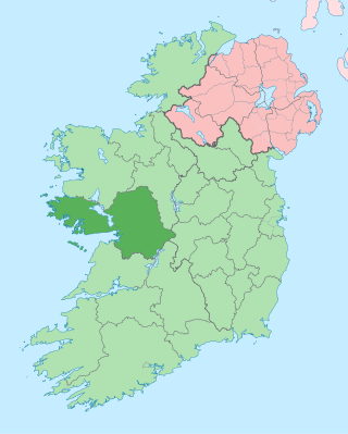
County Galway is a county in Ireland. It is in the Northern and Western Region, taking up the south of the province of Connacht. The county population was 276,451 at the 2022 census.

<span class="mw-page-title-main">Antoine Ó Raifteiri</span> Irish poet (1779–1835)

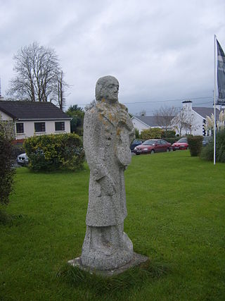
Antoine Ó Raifteirí was an Irish language poet who is often called the last of the wandering bards.

<span class="mw-page-title-main">Oranmore</span> Town in County Galway, Ireland

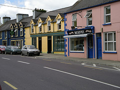
Oranmore is a town in County Galway, Ireland, 9 km (5.6 mi) east of Galway city on an inlet of Galway Bay. At the 2022 census, Oranmore had a population of 5,819.

<span class="mw-page-title-main">Loughrea</span> Town in County Galway, Ireland

Loughrea is a town in County Galway, Ireland. The town lies to the north of a range of wooded hills, the Slieve Aughty Mountains, and Lough Rea, the lake from which it takes its name. The town's cathedral, St Brendan's, dominates the urban skyline.

Anthony Daly was a native of Rahruddy, a townland west of Loughrea, County Galway, Ireland, and a member of the local Whiteboy movement. Daly was hanged on the Hill of Seefin in 1820 for allegedly attempting to assassinate local landlord James Hardiman Burke, father of explorer Robert O'Hara Burke, of St Clerans, Craughwell, County Galway, even though it was widely claimed that he was innocent.

<span class="mw-page-title-main">Western Railway Corridor</span> Irish transport link

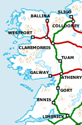
The Western Railway Corridor is a term, used since c. 2003, for a partly disused railway line running through the west of Ireland. Currently two sections of the line, from Limerick via Ennis to Athenry and from Collooney to Sligo, see regular services, with other sections either closed or only technically classed as open.

<span class="mw-page-title-main">Ardrahan</span> Village in County Galway, Ireland

Ardrahan is a village in County Galway, Ireland.

<span class="mw-page-title-main">Ballineen and Enniskean</span> Twin villages in County Cork, Ireland

The twin villages of Ballineen and Enniskeane, or Enniskean, in County Cork in Ireland are 43 km (26.72 mi) southwest of Cork City, on the R586 road. The linear settlement lies on the River Bandon between Bandon and Dunmanway. The combined settlement is designated as a 'key village' by Cork County Council for planning purposes and, as of the 2016 census, had a population of 692 people.

<span class="mw-page-title-main">Aughrim, County Galway</span> Village in County Galway, Ireland

Aughrim is a small village in County Galway, Ireland. It is located between the towns of Loughrea and Ballinasloe, along the old N6 national primary road that used to be the main road between Galway and Dublin. According to the Irish census of 2011, the division had a population of 595.

<span class="mw-page-title-main">Attymon halt</span> Railway station in County Galway, Ireland

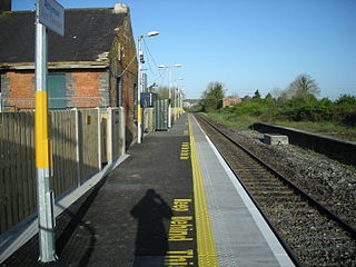
Attymon railway station serves the townland of Attymon in County Galway, Ireland.

<span class="mw-page-title-main">Ahascragh</span> Village in County Galway, Ireland

Ahascragh is a village in east County Galway, Ireland. It is located 11 km (7 mi) north-west of Ballinasloe on the Ahascragh/Bunowen River, a tributary of the River Suck. The R358 regional road passes through the village. As of the 2022 census, it had a population of 186 people.

<span class="mw-page-title-main">R446 road (Ireland)</span> Road between Kinnegad and Galway in Ireland

The R446 road is a regional road in Ireland. The road connects Kinnegad in County Westmeath to Galway City. Prior to the construction of the M6 motorway the R446 formed the main N6 road connecting Dublin and Galway. Following the opening of the M6; the old N6 road was downgraded to regional road status and was designated as the R446. The road is an alternative route between Galway and Dublin and runs in parallel to the M6.

Galway Suburban Rail is a suburban rail service currently operating on the Dublin–Galway line between Galway, Oranmore and Athenry.

<span class="mw-page-title-main">Ó Creachmhaoil</span> Family name

Ó Creachmhaoil is an Irish surname, often anglicised as Craughwell, Croughwell, Crockwell, and Croghwell. Several sources, including Edward MacLysaght's Surnames of Ireland, associate the surname with the village of Craughwell in County Galway.

<span class="mw-page-title-main">Mountbellew</span> Town in County Galway, Connacht, Ireland

Mountbellew or Mountbellew Bridge is a town in County Galway, Ireland. It lies mostly within the townland of Treanrevagh on the N63 national primary road. As of the 2022 census, it had a population of 774.

<span class="mw-page-title-main">Fergal Healy</span> Galway hurler

Fergal Healy is an Irish former hurler and manager. At club level he played with Craughwell, and also lined out at inter-county level with various Galway teams.

Annaghdown is a civil parish in County Galway, Ireland. It lies around Annaghdown Bay, an inlet of Lough Corrib. Villages in the civil parish include Corrandulla and Currandrum. Annaghdown is also an ecclesiastical parish in the Roman Catholic Archdiocese of Tuam and the Church of Ireland Diocese of Tuam, Killala and Achonry.

St. Mary's, Athenry is a Gaelic Athletic Association club located in Athenry in County Galway, Ireland. In men's competitions, the club is a dual club competing in both Gaelic football and hurling at various age levels. The club also competes in camogie competitions, and has won several county, province and national titles in the sport.

Michael 'Hopper' McGrath is an Irish former sportsperson. He played hurling with his local club Sarsfields and was a member of the Galway senior inter-county team in the 1980s and 1990s.

<span class="mw-page-title-main">St Thomas' GAA</span> Gaelic sports club in County Galway, Ireland

Saint Thomas' Gaelic Athletic Club is a Gaelic Athletic Association club located in the Kilchreest and Peterswell areas of County Galway, Ireland. The club is exclusively concerned with the game of hurling.

References

  1. 1 2 "Profile 1 - Population Distribution and Movement F1015 - Population: Craughwell, Co. Galway". Central Statistics Office (Ireland) . Retrieved 21 July 2023.
  2. "Creachmhaoil / Craughwell (see archival records)". Placenames Database of Ireland.
  3. 1 2 "Find a station - Craughwell". irishrail.ie. Irish Rail. Retrieved 23 October 2021.
  4. 1 2 "Craughwell station". eiretrains.com. Retrieved 23 October 2021.
  5. 1 2 3 4 "The Origin and Meaning of the name Craughwell". craughwellns.ie. Craughwell National School. Retrieved 13 March 2024.
  6. 1 2 Record of Monuments and Places County Galway. Dublin: National Monuments and Historical Properties Service. 1997.
  7. "Saint Colman's Catholic Church, Craughwell (Dunkellin By), Craughwell, Galway". buildingsofireland.ie. National Inventory of Architectural Heritage. Retrieved 13 March 2024.
  8. "Ballymore Park, Ballymore (ED Craughwell), Craughwell, Galway". buildingsofireland.ie. National Inventory of Architectural Heritage. Retrieved 13 March 2024.
  9. 1 2 3 Ó Coigligh, Ciarán (October 2009). "Raiftearaí, Antaine (Ó Reachtabhra, Antoine; Raftery, Anthony)". Dictionary of Irish Biography. Royal Irish Academy. doi:10.3318/dib.007572.v1.
  10. Campbell, Fergus (January 2010). "'Reign of terror at Craughwell': Tom Kenny and the McGoldrick murder of 1909". History Ireland. Vol. 18, no. 1. Retrieved 13 March 2024.
  11. "Book Review: The Case of the Craughwell Prisoners during the Land War in Co. Galway, 1879-85". theirishstory.com. Retrieved 13 March 2024.
  12. "The case of the Craughwell Prisoners". Galway Advertiser. 31 May 2012. Retrieved 13 March 2024. A farm at Riverville [..] was vacant. It had been taken by Peter Dempsey and his family. They were boycotted, but on Sunday May 29 [1881], on his way to Mass with his two children, he was shot dead
  13. "June 1st, 1881: Land War victim shot on way to Mass with his children". Irish Times. Republished. 1 June 2010 [1 June 1881]. Archived from the original on 13 March 2024.
  14. "Craughwell AC Facilities". craughwellac.com.
  15. "Route 763 Timetable". citylink.ie.
  16. "Loughrea-Galway Daily Bus Services". healybus.com.
  17. Ó Floinn, Tomás S. R. (October 2009). "Burke, Dominic". Dictionary of Irish Biography. Royal Irish Academy. doi:10.3318/dib.001154.v1 . Retrieved 13 March 2024.
  18. "Fergal Healy announced as Galway U20 hurling manager". galwaybayfm.ie. 13 September 2023. Retrieved 13 March 2024.
  19. "About Us - Brief Club History". Craughwell GAA club. Archived from the original on 19 July 2008.
  20. "Anjelica's Irish Memories". Irish America magazine. June 2002. Retrieved 13 March 2024.
  21. Healy, Tim (21 December 2012). "New owner of Huston's old home in bitter land dispute with neighbour". Irish Independent. Retrieved 13 March 2024.
  22. "Craughwell's Tom Monaghan named in Ireland Squad for the Hurling/Shinty international with Scotland". 5 October 2023. Retrieved 13 March 2024.
  23. "Robert O'Hara Burke". A Compendium of Irish History. Library Ireland. Retrieved 8 June 2024.