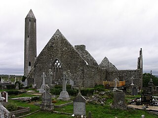
Kilmacduagh is a small village in south County Galway, Ireland, near Gort. The village is in a townland and civil parish of the same name, in Kiltartan barony.
Killagoola is a small townland lying in the civil parish of Moycullen in County Galway, Ireland. It is located about 8 miles from Galway city, just off the N59 road which travels north from Galway towards Clifden. Its name is derived from the Irish name of Cill Ogúla, which means Church on the Shoulder. Indeed there is the ruins of a small church within the boundaries of Killagoola, on the largest site in the area, Crú Hill.
Kiltormer is a village in County Galway, Ireland. It is about 8 miles from Ballinasloe. The village is in a civil parish of the same name.

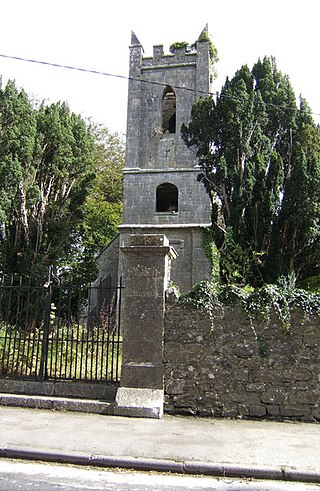
Kiltartan is a barony and civil parish in County Galway, Ireland. The southern portion of this barony was formerly known as Cenél Áeda na hEchtge or O'Shaughnessy's Country, the northern portion was called Coill Ua bhFiachrach and the eastern part was called Oireacht Réamoinn. It was the home of Lady Gregory, Edward Martyn, and a regular residence of W. B. Yeats. The barony takes its name from the Burke stronghold of Kiltartan Castle also known as Castletown or Ballycastle. The castle in turn takes its name from the medieval church of Kiltartan a short distance to the north. The old Irish name for the church and parish was Cill Athrachta which was corrupted to Cill Tortain. The older anglicised form was Kiltaraght which is closer to the original Irish form.
Kilmihil is a village in the Barony of Clonderlaw, west County Clare, Ireland. It is also a civil parish and an ecclesiastical parish in the Roman Catholic Diocese of Killaloe. The area was officially classified as part of the West Clare Gaeltacht; an Irish-speaking community; until 1956.
Kilgevrin is a townland near the village of Milltown in north County Galway, Ireland. It is situated in the civil parish of Liskeevy, in the historical barony of Dunmore. Kilgevrin is 3.1 square kilometres (1.2 sq mi) in area, and is bounded on the north by the parish of Addergoole and townland of Banagher, on the east by both Banagher and Clashaghanny and on the south and west by the parish of Kilbannon and Tuam.

Kilquade, historically Killcowade, is a townland and a Roman Catholic parish in north County Wicklow, Ireland. It lies between Kilpedder and Kilcoole, about one kilometre east of Junction 12 (Kilpedder) of the N11 national primary route. It is part of the barony of Newcastle and lies within both the civil parishes of Kilcoole and Newcastle Lower.
Kilkerrin is a village in County Galway, Ireland. It is situated on the R364 regional road 6 km (4 mi) south of the town of Glenamaddy. The village is in a townland and civil parish of the same name. Features in the area include Kiltullagh Lake and the Lough Lurgeen raised bog.
Killoughey, officially Killoughy and historically "Killaghy" or "Killahy", is a townland and civil parish south-west of Tullamore in County Offaly, Ireland.

Kilmactigue, also Kilmacteige, is a townland and Catholic parish in County Sligo, Ireland. Kilmacteige is also a civil parish.
Killukin, sometimes known as Killucan, is a civil parish in the barony of Boyle, County Roscommon in Ireland. It is located on the road from Carrick-on-Shannon to Elphin containing part of the market and post town of Carrick. It is bounded on the north by the parish of Toomna, on the west by the parishes of Eastersnow and Ardcarne, on the south by the parish of Killummond, and on the east by the River Shannon.
Killimordaly is a rural village and civil parish in County Galway, Ireland. It was originally located in Trícha Máenmaige.

Kildress is a village and civil parish on the outskirts of Cookstown in County Tyrone, Northern Ireland.

Kilkishen is a village in southeast County Clare, Ireland. The village is 8 kilometres (5 mi) east of Quin and 14 kilometres (8.7 mi) north of Shannon.
Kiltivna, also spelled Kiltevna, is a townland in the civil parish of Dunmore in County Galway, Ireland. It is located between the towns of Dunmore and Glenamaddy. The townland, which is 0.78 kilometres (0.48 mi) in area, had a population of 33 people as of the 2011 census.
Kilmurry Ibrickane is a civil parish in County Clare, Ireland, The parish is part of the historic barony of Ibrickane. In 1837, it was co-extensive with the parish of the Established Church and of the Catholic Church. The civil parish contains the tiny settlement of Kilmurry which was the location of the church before the Cromwellian conquest of Ireland. Today, an ecclesiastical parish in the Roman Catholic Diocese of Killaloe of the same name exists which covers part of the civil parish. In the Church of Ireland, the parish is part of the "Drumcliffe Union with Kilnasoolagh" which covers the western part of the county of Clare, roughly that part located to the west of the M18 motorway.
Kilmurry-Negaul is a civil parish and a village in County Clare, Ireland.

Kilmocar or Kilmacar is a townland and civil parish in County Kilkenny, Ireland. The ruins of a medieval church lie within Kilmacar townland.

Kiltoom, also Kiltomb, is a civil parish as well as an electoral division in County Roscommon, Ireland. There is also an eponymous townland in the parish. Kiltoom is located northwest of Athlone on the southwestern shore of Lough Ree.

Kiltullagh is a village and civil parish in County Galway, Ireland. Located on the R348 regional road, the M6 motorway passes nearby. As of 2011, the townlands of Kiltullagh South and Kiltullagh North, in Kiltullagh civil parish, had a combined population of 93 people.
