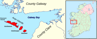
The Aran Islands or The Arans are a group of three islands located at the mouth of Galway Bay, on the west coast of Ireland, with a total area around 46 km2 (18 sq mi). They constitute the barony of Aran in County Galway, Ireland.

Menemsha is a small fishing village located in the town of Chilmark on the island of Martha's Vineyard in Dukes County, Massachusetts, United States. It is located on the east coast of Menemsha Pond, adjacent to the opening into the Vineyard Sound on the pond's northern end. The village's historic harbor serves as the point of departure for local fishermen, some from multi-generational fishing families, as well as charter boats to the Elizabeth Islands and elsewhere. Besides charter fishing and cruises, other amenities are the public beach adjacent to the harbor and the bicycle ferry across Menemsha Pond to Aquinnah. Menemsha is the location of a United States Coast Guard station, Coast Guard Station Menemsha, and was once known as Menemsha Creek. It was the shooting background for the fictional "Amity Island" of Steven Spielberg's 1975 film Jaws.

Murueta is a town and municipality located in the province of Biscay, in the autonomous community of Basque Country, northern Spain. According to the 2019 census, it has 308 inhabitants.
Bjerkøya is a populated island in the municipality of Sande, Norway. It has a population of 265.
Inis Beag is a remote island off the coast of Connemara, Ireland, near the Aran Islands. It contains a small, isolated Irish-speaking Catholic community which cultural anthropologist John Cowan Messenger observed in the 1960s, leading to several longer treatises, including "Inis Beag: Isle of Ireland" and "Sex and Repression in an Irish Folk Community". During the period of his study between 1958 and 1966, Inis Beag supported a population of around 350, mostly living by subsistence farming and fishing. The name "Inis Beag" is a name made up by researchers to protect the privacy of the island's people. Its true identity is Inisheer.
Chudleigh railway station was a railway station in Chudleigh, a small town in Devon, England located between the towns of Newton Abbot and Exeter.

Wimborne is a hamlet in southern Alberta, Canada within Kneehill County. It is located approximately 58 km (36 mi) southeast of Red Deer. It has an elevation of 975 m (3,199 ft).

D.L. MacDonald Yard is the maintenance facility, garage, and operations centre for the Capital and Metro light rail transit lines operated by Edmonton Transit Service, in Edmonton, Alberta, Canada. Located to the northeast in the Kennedale industrial area, at 13310 - 50A Street, the facility opened in December 1983 at a cost of $28.2 million.

Bladowo is a village in the administrative district of Gmina Tuchola, within Tuchola County, Kuyavian-Pomeranian Voivodeship, in north-central Poland. It lies approximately 3 kilometres (2 mi) west of Tuchola and 55 km (34 mi) north of Bydgoszcz.

Lubcza is a village in the administrative district of Gmina Więcbork, within Sępólno County, Kuyavian-Pomeranian Voivodeship, in north-central Poland. It lies approximately 10 kilometres (6 mi) west of Więcbork, 17 km (11 mi) south-west of Sępólno Krajeńskie, and 51 km (32 mi) north-west of Bydgoszcz.

Morzyczyn is a village in the administrative district of Gmina Kobylanka, within Stargard County, West Pomeranian Voivodeship, in north-western Poland. It lies approximately 8 kilometres (5 mi) west of Stargard and 24 km (15 mi) east of the regional capital Szczecin.

Port Kenyon is an unincorporated community in Humboldt County, California. It is located 1.5 miles (2.4 km) northwest of Ferndale, at an elevation of 13 feet.

The William T. Davis Wildlife Refuge (WTDWR) is an 814-acre (3.29 km2) wildlife refuge straddling the New Springville and Travis sections of Staten Island. The park was named in honor of Staten Island native William T. Davis, a renowned naturalist and entomologist who along with the Audubon Society started the refuge with an original acquisition of 52 acres (210,000 m2). Additional acreage was acquired in increments and the park is today 814 acres (3.29 km2). Beginning in 2010, the adjacent 223-acre (0.90 km2) North Park section of Freshkills Park has undergone preparation to serve as an expansion of the wildlife refuge.

The North Magnetic Pole is a point on the surface of Earth's Northern Hemisphere at which the planet's magnetic field points vertically downwards. There is only one location where this occurs, near the Geographic North Pole. The Geomagnetic North Pole, a related point, is the pole of an ideal dipole model of the Earth's magnetic field that most closely fits the Earth's actual magnetic field.

Dún Dúchathair or simply Dúchathair, meaning "black fort", is a large stone fort on the cliffs at Cill Éinne, (Killeany), Inishmore in County Galway, Ireland. Due to erosion, it now sits on a rocky promontory that stretches out into the sea. On its outer side there are large walls, reaching 6 metres high and 5 metres wide. On the inside are the ruins of clocháns. There is also evidence of a cheval de frise protecting the entrance.

Rejas is a ward (barrio) of Madrid belonging to the district of San Blas-Canillejas.

Inishbarra is an island in County Galway situated east of the mouth of Kilkieran bay. An artificial causeway links the island to the mainland but this is only usable at very low tide.
Inishcottle is an uninhabited island in Clew Bay, County Mayo, Ireland.
Bay Creek is a stream in Oregon County in the Ozarks of southern Missouri. It is a tributary of the Warm Fork Spring River.

Banner is an unincorporated community in Franklin Township, Jackson County, Ohio, United States. It is located between Jackson and Oak Hill near the intersection of Clay Banner Road and Franklin Valley Road, at 38°56′24″N82°35′42″W.


