
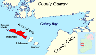
Inishbarra (Irish : Inis Bearachain [1] ) is an island in County Galway [2] situated east of the mouth of Kilkieran bay. An artificial causeway links the island to the mainland but this is only usable at very low tide. [3]
Inishbarra (Irish : Inis Bearachain [1] ) is an island in County Galway [2] situated east of the mouth of Kilkieran bay. An artificial causeway links the island to the mainland but this is only usable at very low tide. [3]
|
|
| |||||||||||||||||||||||||||||||||||||||||||||||||||||||||||||||||||||||||||||||||||||||
| Source: Central Statistics Office. "CNA17: Population by Off Shore Island, Sex and Year". CSO.ie. Retrieved 12 October 2016. | |||||||||||||||||||||||||||||||||||||||||||||||||||||||||||||||||||||||||||||||||||||||||

Island Lake is a village in Lake and McHenry counties in the U.S. state of Illinois. Per the 2020 census, the population was 8,051. The village surrounds Island Lake, a lake which contains a small island.

The Rosses is a traditional 'district' in the west of County Donegal in Ulster, the northern province in Ireland. The Rosses has a population of over 7,000 centred on the town of Dungloe, which acts as the educational, shopping and civic centre for the area. Defined by physical boundaries in the form of rivers, as well as history and language use, the area has a distinctive identity, separate from the rest of County Donegal. The extensive district lies between the parish and district of Gweedore to the north and the town of Glenties to the south. A large part of the Rosses is in the Gaeltacht, which means that Irish is the spoken language. The Rosses, Cloughaneely and Gweedore, known locally as "the three parishes", with 16,000 Irish speakers, together form a social and cultural region different from the rest of the county, with Gweedore serving as the main centre for socialising and industry. Gaeltacht an Láir is another Irish-speaking area.

The Quoile is a river in County Down, Northern Ireland.
Inishmore is the largest of the Aran Islands in Galway Bay, off the west coast of Ireland. With an area of 31 km2 (12 sq mi) and a population of 820, it is the second-largest island off the Irish coast and most populous of the Aran Islands.
Loch Gabhar (Lagore), meaning "Lake of the Goats", is an area in the barony of Ratoath, County Meath, Ireland. It is located between the villages of Ratoath and Dunshaughlin and is the namesake of the townlands of Lagore Big and Lagore Little.

The South Circular Road, designated as the R811 regional road, is a road in Dublin, Ireland. One of the longest in the city, it runs from Islandbridge in the west, through Rialto and Dolphin's Barn to Portobello, near the centre. It runs mainly through residential areas and is used by numerous bus routes. It is the southside equivalent of the North Circular Road.
Ovayok Territorial Park is a park situated 15 km (9.3 mi) east of Cambridge Bay, in the Kitikmeot Region, Nunavut, Canada. The park is relatively small and covers an area of approximately 16 km2 (6.2 sq mi). The park can be accessed by vehicle from the community as a gravel road runs directly to it.
Inis Beag is a pseudonymous Irish island in the 1960s, as described by American cultural anthropologist John Cowan Messenger. Messenger lived on the island and studied the community in 1959 and 1960. He subsequently wrote several academic works about his experience, including Inis Beag: Isle of Ireland and Sex and Repression in an Irish Folk Community.
Coney Island is an island in Lough Neagh, Northern Ireland. It is about 1 km offshore from Maghery in County Armagh, is thickly wooded and of nearly 9 acres (36,000 m2) in area. It lies between the mouths of the River Blackwater and the River Bann in the south-west corner of Lough Neagh. Boat trips to the island are available at weekends from Maghery Country Park or Kinnego Marina. The island is owned by the National Trust and managed on their behalf by Armagh City, Banbridge and Craigavon Borough Council. Coney Island Flat is a rocky outcrop adjacent to the island. Although Samuel Lewis called Coney Island the only island in County Armagh, Armagh's section of Lough Neagh also includes Croaghan Island, as well as the marginal cases of Padian and Derrywarragh Island.
Nuussuaq Peninsula is a mainland peninsula in northwestern Greenland, located at the northern end of Upernavik Archipelago, approximately 70 km (43 mi) to the south of Melville Bay. It is much smaller than its namesake in western Greenland.
Chalk Level is an unincorporated community in Pittsylvania County, in the U.S. state of Virginia.
Johnny Óg Connolly is an Irish musician.

Dún Dúchathair or simply Dúchathair, meaning "black fort", is a large stone fort on the cliffs at Cill Éinne, (Killeany), Inishmore in County Galway, Ireland. Due to erosion, it now sits on a rocky promontory that stretches out into the sea. On its outer side there are large walls, reaching 6 metres high and 5 metres wide. On the inside are the ruins of clocháns. There is also evidence of a cheval de frise protecting the entrance.
Johnny Connolly was an Irish musician from Connemara, and one of Ireland's most prominent players of the melodeon. In a 2008 TG4 interview, Connolly described how he first took up the instrument: his parents left the children home at Inis Bearacháin to go watch currach racing, and Connolly's sister showed him where their parents kept their melodeon locked up, which he commenced to play for the rest of the day, beginning his ties to the instrument. Connolly has been described as "king of the melodeon", the best player of his generation, and catalyst for increased interest in the single-row melodeon in Irish music.

Saint Caomhán, anglicised as Cavan, sometimes Kevin, is the patron saint of Inisheer, the smallest of the Aran Islands. Although he is "by far the most celebrated of all the saints of the Aran Islands", little is known about him. He is said to have been a disciple of Saint Enda of Aran.
Inis Rath is an island located in Lough Erne, in County Fermanagh, Northern Ireland. It is also known as Hare Krishna Island.

Orcasitas is a ward (barrio) of Madrid belonging to the district of Usera.
Inisheltia is an uninhabited island in County Galway. There are few buildings on the island, but the ruins of an abandoned farmhouse and cottage remain.
Inishgort is an island in Clew Bay, County Mayo. Inishgort is home to Inishgort lighthouse, originally opened in 1806.
Inishcottle is an inhabited island in Clew Bay, County Mayo, Ireland.
53°16′40″N9°42′43″W / 53.27778°N 9.71194°W
| | This article related to the geography of County Galway, Ireland is a stub. You can help Wikipedia by expanding it. |