Tiaquin Tigh Dachoinne (Irish) | |
|---|---|
 Lough Nahinch near Menlough | |
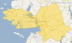
 Barony map of County Galway, 1900; Tiaquin is in the northeast, coloured green. | |
 Tiaquin | |
| Coordinates: 53°29′N8°34′W / 53.48°N 8.57°W | |
| Sovereign state | Ireland |
| Province | Connacht |
| County | Galway |
| Area | |
• Total | 445.7 km2 (172.1 sq mi) |
Tiaquin (Irish : Tigh Dachoinne) is a historical barony in eastern County Galway, Ireland.
Contents
Baronies were mainly cadastral rather than administrative units. They acquired modest local taxation and spending functions in the 19th century before being superseded by the Local Government (Ireland) Act 1898. [1]
