
Abong-Mbang is a town and commune in the East Region of Cameroon. Abong-Mbang is located at a crossroads of National Route 10 and the road that leads south to Lomié. Yaoundé, the capital of Cameroon, is 178 km to the west, and Bertoua, the capital of the East Province, lies 108 km to the east. From Ayos, at the border in the Centre Province 145 km (90 mi) from Abong-Mbang, the tar on National Route 10 ends and a dirt road begins. Abong-Mbang is the seat of the Abong-Mbang sub-division and the Haut-Nyong division. The town is headed by a mayor. Gustave Mouamossé has held the post since August 2002. Abong-Mbang is site of one of the East Province's four Courts of First Instance and a prefectural prison. The population was estimated at 18,700 in 2001.

Lamu or Lamu Town is a small town on Lamu Island, which in turn is a part of the Lamu Archipelago in Kenya. Situated 341 kilometres (212 mi) by road northeast of Mombasa that ends at Mokowe Jetty, from where the sea channel has to be crossed to reach Lamu Island, it is the headquarter of Lamu County and a UNESCO World Heritage Site.

The North Region makes up 66,090 km2 of the northern half of The Republic of Cameroon. Neighbouring territories include the Far North Region to the north, the Adamawa Region to the south, Nigeria to the west, Chad to the east, and Central African Republic to the southeast. The city of Garoua is both the political and industrial capital. Garoua is Cameroon's third largest port, despite the fact that the Bénoué River upon which it relies is only navigable for short periods of the year.

The Kirdi are the many cultures and ethnic groups who inhabit northwestern Cameroon and northeastern Nigeria.

The Mandara Mountains are a volcanic range extending about 190 km along the northern part of the Cameroon–Nigeria border, from the Benue River in the south to the north-west of Maroua in the north. The highest elevation is the summit of Mount Oupay, at 1,494 m (4,900 ft) above sea level.

Kapsiki (Ka-Tsepkye) is a people living on both sides of the border between North Cameroon and Northeast Nigeria. They are called Kapsiki in Cameroon, and Kamwe (Higi) in Nigeria. Together they amount to about 120,000 people. Their language, Psekiye or Kamwe, consists of eleven dialects including Nkafa, Sina, Ghye, Humsi, Dakwa and Tilli and belongs to the Chadic language family.
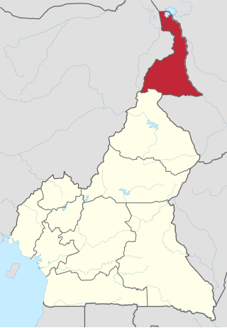
The Far North Region, also known as the Extreme North Region, is the northernmost and most populous constituent province of the Republic of Cameroon. It borders the North Region to the south, Chad to the east, and Nigeria to the west. The capital is Maroua.

Sukur or Sukur Cultural Landscape is a UNESCO World Heritage Site located on a hill above the village of Sukur in the Adamawa State of Nigeria. It is situated in the Mandara Mountains, close to the border with Cameroon. Its UNESCO inscription is based on the cultural heritage, material culture, and the naturally-terraced fields. Sukur is Africa's first cultural landscape to receive World Heritage List inscription.

The Sao civilization flourished in Central Africa from the 6th century BCE or 5th century BCE, to as late as the 16th century AD. The Sao lived by the Chari River basin in territory that later became part of Cameroon and Chad. They were the earliest civilization to have left clear traces of their presence in the territory of modern Cameroon. Sometime around the 16th century, conversion to Islam changed the cultural identity of the former Sao. Today, several ethnic groups of northern Cameroon and southern Chad, but particularly the Sara and Kotoko, claim descent from the civilization of the Sao.

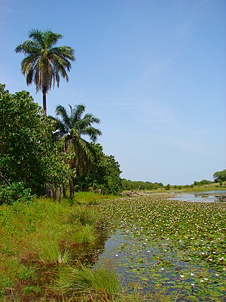
Tourism in Cameroon is a growing but relatively minor industry. Since the 1970s, the government of Cameroon has cultivated the industry by creating a ministry of tourism and by encouraging investment by airlines, hotels, and travel agencies. The government describes the country as "Africa in miniature", promoting its diversity of climate, culture, and geography. Cameroon's wildlife draws both safari-goers and big-game hunters, as Cameroon is home to many of Africa's iconic animals: cheetahs, chimpanzees, elephants, giraffes, gorillas, hippopotami, and rhinoceroses. Impediments to further growth of the tourism sector include poor transport infrastructure and corrupt officials who may harass visitors for bribes.
Moni Bilé is a Cameroonian makossa musician. He was the best-selling makossa performer of the 1980s, and his album Amour & Espérance was an international hit that extended the worldwide popularity of the genre.
Francis Bebey was a Cameroonian musicologist, writer, composer, and broadcaster.
Tourism in Benin is a small industry. In 1996, Benin had approximately 150,000 tourists. By 2014 number rose to 242,000. A small country with a high concentration of tourist attractions, Benin's national parks and culture are among its main tourist attractions. Abomey is one of Benin's main tourist attractions, with palaces that became a World Heritage Site in 1982. The capital city Porto Novo's attractions include its museums and architecture.
Kiang West National Park is one of the largest and most important wildlife reserves in the Gambia. It was declared a national park in 1987 and is managed by the Gambia Department of Parks and Wildlife Management.
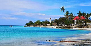
Nungwi, or Ras Nungwi, is a large village located in the far northern end of the island of Zanzibar. With a population of 30,762, Nungwi is the second largest settlement on the island. It is situated in the Nungwi Ward in the Kaskazini A District of the Unguja North Region. It is about 35 miles (56 km) north of Zanzibar Town on the Nungwi Peninsula, about an hour drive from Stone Town. To the south Nungwi shares a border with the neighboring Matemwe- and Tazari villages. Nungwi was traditionally a fishing village and dhow-building center, but is now a popular tourist destination, and for instance recognized in CNN’s list of "100 best beaches of the world" in 2014. West Nungwi has changed a lot since the 1990s and is now a popular tourist destination with numerous resorts, restaurants, bars, stores, etc. East Nungwi is quieter and generally more laid-back.
Mount Kupe or Mont Koupé is a plutonic mountain in the Western High Plateau of Cameroon, part of the Cameroon line of volcanoes. It is the highest of the Bakossi Mountains, rising to 2,064 metres (6,772 ft).

The Menchum River and its tributaries drains a large area of the Northwest Region of Cameroon. It in turn is a tributary of the Benue River in Nigeria.

Lake Sonfon, also known as Lake Confon, is a fresh water mountain lake in Diang, Sierra Leone that is of religious and cultural significance.
Marché du Niger is a market in Conakry, Guinea, slightly smaller than the other main market in the city, Marché Madina. It sells fruits and vegetables but reportedly has an issue with pickpocketing.


