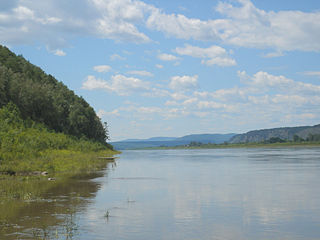
Komsomolsk-on-Amur is a city in Khabarovsk Krai, Russia, located on the left bank of the Amur River in the Russian Far East. It is located on the Baikal-Amur Mainline, 356 kilometers (221 mi) northeast of Khabarovsk. As of 2010, it had a population of 263,906 (2010 Census); 281,035 (2002 Census); 315,325 (1989 Census).

Nikolayevsk-on-Amur is a town in Khabarovsk Krai, Russia located on the Amur River close to its liman in the Pacific Ocean. Population: 22,752 (2010 Census); 28,492 (2002 Census); 36,296 (1989 Census).

Sovetskaya Gavan is a town in Khabarovsk Krai, Russia, and a port on the Strait of Tartary which connects the Sea of Okhotsk in the north with the Sea of Japan in the south. Population: 27,712 (2010 Census); 30,480 (2002 Census); 34,915 (1989 Census).

Nikolay Nikolayevich Muravyov-Amursky was a Russian general, statesman and diplomat, who played a major role in the expansion of the Russian Empire into the Amur River basin and to the shores of the Sea of Japan.

Amursk is a town in Khabarovsk Krai, Russia, located on the left bank of the Amur River 45 kilometers (28 mi) south of Komsomolsk-on-Amur. Population: 42,970 (2010 Census); 47,759 (2002 Census); 58,395 (1989 Census).
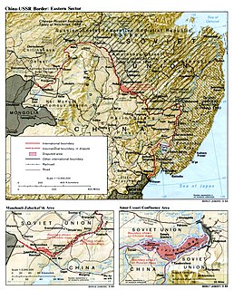
Bolshoi Ussuriysky Island, or Heixiazi Island, is a sedimentary island at the confluence of the Ussuri and Amur rivers. It is divided between the People's Republic of China (PRC) and Russia. It has an area of about 327 to 350 km² and is bounded closely by Yinlong Island, and over ninety islets. Its position at the confluence of the Amur and the Ussuri and right next to the major Russian city of Khabarovsk, has given it great strategic importance.
The Nanai language is spoken by the Nanai people in Siberia, and to a much smaller extent in Mongolia's Taiga province, where it is known as Hezhe. The language has about 1,400 speakers out of 17,000 ethnic Nanai, but most are also fluent in Russian or Mongolian, and mostly use one of those languages for communication.

The Yenisei Gulf is a large and long estuary through which the lower Yenisei River flows into the Kara Sea.
The Chastye Islands is an island group in the southern end of the Sea of Okhotsk. It is located in Tatar Strait, between the mainland shore and the western coast of Sakhalin. Although there are some settlements on the adjacent coast, the Chastye Islands are uninhabited.
Far Eastern Railway is a railway in Russia that crosses Primorsky Krai, Khabarovsk Krai, Amur Oblast, Jewish Autonomous Oblast, and Yakutia.

The Nevelskoy Strait is a strait between the Khabarovsk Krai mainland and Sakhalin island in Sakhalin Oblast, all of the Russian Far East region in Northeast Asia.
The Amur Annexation was the incorporation of the southeast corner of Siberia into Russia in 1858–1860. The two areas involved are the Priamurye between the Amur River and the Stanovoy Range to the north and the Primorye which runs down the coast from the Amur mouth to the Korean border, and does not include the island of Sakhalin. The territory of Outer Manchuria was formerly under the control of the Qing dynasty.

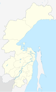
Komsomolsky District is an administrative and municipal district (raion), one of the seventeen in Khabarovsk Krai, Russia. It is located in the southern central part of the krai. The area of the district is 25,167 square kilometers (9,717 sq mi). Its administrative center is the city of Komsomolsk-on-Amur. Population: 29,072 (2010 Census); 31,563 (2002 Census); 33,649 (1989 Census).
Menshikov Island is an island in the Sea of Okhotsk located east of the Shantar Islands.

Bolon Nature Reserve is the oldest Russian 'zapovednik' in the Russian Far East. It is located on the Middle Amur River lowlands adjacent to the south-west of Lake Bolon. The reserve covers the wetlands of international importance. Large numbers of migratory waterfowl use the area for nesting and stopovers on long flights. The reserve is situated half way between the city of Khabarovsk and Komsomolsk-on-Amur, in the Amursky District of Khabarovsk Krai. The reserve was created in 1997, and covers an area of 100,000 ha (390 sq mi).
Khabarovsk Airlines, stylised KhabAvia, is a Russian state-owned airline with bases at Khabarovsk and Nikolayevsk-on-Amur. Established in 2004, the airline operates nine Antonov and Let aircraft as of December 2016. Its flight schedule, accessed in December 2016, states that Khabarovsk Airlines flies to ten destinations.

Asian Highway 30 or AH30 is a route located in Russia, running 2,785 kilometres (1,731 mi) from Ussuriysk, Primorsky Krai to Chita, Zabaykalsky Krai. Khabarovsk to Chita section of this asian highway is named after Amur river as Amur Highway.