Chastye Islands

Last updated
Chastye Is.
Острова Частые
Island group
Russia Khabarovsk Krai location map.svg
Red pog.svg
Chastye Is.
Coordinates: 52°30′N141°21′E / 52.500°N 141.350°E / 52.500; 141.350
Country Russian Federation
Federal subject Khabarovsk Krai

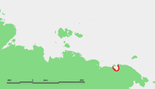
The Chastye Islands (Russian : Острова Частые; Ostrova Chastye) is an island group in the southern end of the Sea of Okhotsk. It is located in Tatar Strait, between the mainland shore and the western coast of Sakhalin. [1] Although there are some settlements on the adjacent coast, the Chastye Islands are uninhabited.

Russian language East Slavic language

Russian is an East Slavic language, which is official in the Russian Federation, Belarus, Kazakhstan and Kyrgyzstan, as well as being widely used throughout Eastern Europe, the Baltic states, the Caucasus and Central Asia. It was the de facto language of the Soviet Union until its dissolution on 25 December 1991. Although, nowadays, nearly three decades after the breakup of the Soviet Union, Russian is used in official capacity or in public life in all the post-Soviet nation-states, as well as in Israel and Mongolia, the rise of state-specific varieties of this language tends to be strongly denied in Russia, in line with the Russian World ideology.

Sea of Okhotsk A marginal sea of the western Pacific Ocean, between the Kamchatka Peninsula, the Kuril Islands, the island of Hokkaido, the island of Sakhalin, and eastern Siberian coast

The Sea of Okhotsk is a marginal sea of the western Pacific Ocean, between the Kamchatka Peninsula on the east, the Kuril Islands on the southeast, the island of Hokkaido to the south, the island of Sakhalin along the west, and a long stretch of eastern Siberian coast along the west and north. The northeast corner is the Shelikhov Gulf. The sea is named after Okhotsk, the first Russian settlement in the Far East.

Sakhalin large Russian island in the North Pacific Ocean

Sakhalin is Russia's largest island, lying in the North Pacific Ocean between 45°50' and 54°24' N. It is administered as part of Sakhalin Oblast. Sakhalin, which is about one third the size of Honshu, is just off the east coast of Russia, and just north of Japan. The island's population was 497,973 as of the 2010 census, made up of mostly ethnic Russians and a smaller Korean community. The indigenous peoples of the island are the Ainu, Oroks and Nivkhs.

Contents

Administratively the Chastye Islands belong to the Khabarovsk Krai of the Russian Federation.

Khabarovsk Krai First-level administrative division of Russia

Khabarovsk Krai is a federal subject of Russia. It is geographically located in the Far East region of the country and is a part of the Far Eastern Federal District. The administrative center of the krai is the city of Khabarovsk, which is home to roughly half of the krai's population and the second largest city in the Russian Far East. Khabarovsk Krai is the fourth-largest federal subject by area, with a population of 1,343,869 as of the.

Islands

Ecology

These small islands are a home for a great variety of seabirds. [4] [5]

Related Research Articles

Manuel I Komnenos Byzantine Emperor

Manuel I Komnenos was a Byzantine Emperor of the 12th century who reigned over a crucial turning point in the history of Byzantium and the Mediterranean. His reign saw the last flowering of the Komnenian restoration, during which the Byzantine Empire had seen a resurgence of its military and economic power, and had enjoyed a cultural revival.

Severnaya Zemlya Archipelago in Krasnoyarsk Krai, Russian Federation

Severnaya Zemlya is a 37,000-square-kilometre (14,000-square-mile) archipelago in the Russian high Arctic. It lies off Siberia's Taymyr Peninsula, separated from the mainland by the Vilkitsky Strait. This archipelago separates two marginal seas of the Arctic Ocean, the Kara Sea in the west and the Laptev Sea in the east.

Shantar Islands Island group in Far Eastern Federal District, Russian Federation

The Shantar Islands are a group of fifteen islands located off the northwestern shore of the Sea of Okhotsk east of Uda Gulf and north of Academy Bay. Most of the islands have rugged cliffs, but they are of moderate height; the highest point in the island group is 720 metres.

Routan Islands island

The Routan Islands(Chukot: Ровтын иӆирти Rovtįn iłirti) are two islands in the eastern coast of the Chaunskaya Bay of the East Siberian Sea. They are located directly off Pevek, separated from the shore of the Pevek Peninsula by a 4.7 km wide sound. Ayon Island lies on the other side of the Chaunskaya Bay, 24 km to the west.

Alexandrovka, also romanized Aleksandrovka, is a common name shared by a number of rural localities in Russia. It is typically derived from or related to the first name Alexander.

Kodaikanal–Munnar Road road in Tamil Nadu, India

The Kodaikanal–Munnar Road was located in Dindigul District and Theni District of Tamil Nadu and Idukki district of Kerala in South India. It covers 81 kilometers (50 mi) from Kodaikanal to Munnar. The road was improved by the British in 1942 as an evacuation route in preparation for a possible Japanese invasion of South India. With a maximum elevation of 2,480 meters (8,140 ft) just south of Vandaravu Peak, it was among the highest roads in India, south of the Himalayas, prior to its closure in 1990.

Timeline of European exploration timeline

The following timeline covers European exploration from 1418 to 1957.

Sino-Russian relations since 1991

China–Russia relations, also known as Sino-Russian relations, refers to international relations between the People's Republic of China and the Russian Federation. Diplomatic relations between China and Russia dramatically improved after the dissolution of the Soviet Union and the establishment of the Russian Federation in 1991. American scholar Joseph Nye argues:

Commercial open-boat whaling by American and European ships occurred in the Sea of Okhotsk from the 1830s to the early 1900s. They primarily caught right and bowhead whales. Both populations of these species declined drastically, with the latter once thought to be extinct by western historians. Peak catches were made in the 1840s and 1850s. It's estimated that as many as 15,200 bowheads and 2,400 rights were taken in the sea.

References