Magadan is a port town and the administrative center of Magadan Oblast, Russia. The city is located on the isthmus of the Staritsky Peninsula by the Nagaev Bay; it serves as a gateway to the Kolyma region.

Khabarovsk Krai is a federal subject of Russia. It is located in the Russian Far East and is administratively part of the Far Eastern Federal District. The administrative centre of the krai is the city of Khabarovsk, which is home to roughly half of the krai's population and the largest city in the Russian Far East. Khabarovsk Krai is the fourth-largest federal subject by area, and had a population of 1,343,869 as of 2010.

Chukotka, officially the Chukotka Autonomous Okrug, is the easternmost federal subject of Russia. It is an autonomous okrug situated in the Russian Far East, and shares a border with the Republic of Sakha to the west, Magadan Oblast to the south-west, and Kamchatka Krai to the south, as well as a maritime border on the Bering Strait with the U.S. state of Alaska to the east. Anadyr is the largest town and the capital, and the easternmost settlement to have town status in Russia.
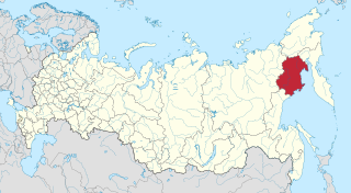
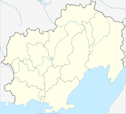
Magadan Oblast is a federal subject of Russia. It is geographically located in the Far East region of the country, and is administratively part of the Far Eastern Federal District. Magadan Oblast has a population of 136,085, making it the least populated oblast and the third-least populated federal subject in Russia.

UTC+11:00 is an identifier for a time offset from UTC of +11:00. This time is used in:

There are eleven time zones in Russia, which currently observe times ranging from UTC+02:00 to UTC+12:00. Daylight saving time (DST) has not been used in Russia since 26 October 2014. From 27 March 2011 to 26 October 2014, permanent DST was used.
Susuman Airport is a minor airport built 2 kilometres (1.2 mi) south of Susuman in Magadan Oblast, Russia

The Extreme North or Far North is a large part of Russia located mainly north of the Arctic Circle and boasting enormous mineral and natural resources. Its total area is about 5,500,000 square kilometres (2,100,000 sq mi), comprising about one-third of Russia's total area. Formally, the regions of the Extreme North comprise the whole of Chukotka Autonomous Okrug, Kamchatka Krai, Magadan Oblast, Murmansk Oblast and Sakha, as well as certain parts and cities of Arkhangelsk Oblast, Irkutsk Oblast, Khabarovsk Krai, Komi Republic, Krasnoyarsk Krai, Republic of Karelia, Sakhalin Oblast, Tuva, Tyumen Oblast, as well as all islands of the Arctic Ocean, its seas, the Bering Sea, and the Sea of Okhotsk.
Magadan Time (MAGT) is a time zone in Russia, named after Magadan, the administrative center of Magadan Oblast. It is 11 hours ahead of UTC (UTC+11) and 8 hours ahead of Moscow Time (MSK+8).
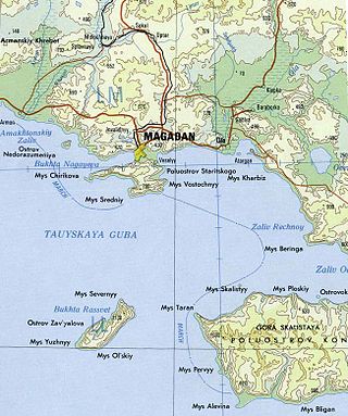
Zavyalov Island, formerly Ola Island, is a relatively large island in the Sea of Okhotsk, northwestern Pacific. It is located on the eastern side of Taui Bay, 20 km (12 mi) west of Cape Taran, Koni Peninsula, about 50 km (31 mi) south of the city of Magadan.
Nedorazumeniya Island is an island on the north coast of the Sea of Okhotsk. It lies on the north side of Taui Bay, between Amakhton Bay to the west and Nagaev Bay to the east. It is about 20 kilometres (12 mi) west of the city of Magadan.

The Yam Islands, Yamsky Islands or Yamskiye Islands, is a small island group located close to the coast in the northern Sea of Okhotsk. Administratively the Yam Islands belong to the Magadan Oblast of the Russian Federation.
Chetyre Paltsa is a small island in the northern shores of Gizhigin Bay, Sea of Okhotsk. It is located 7 km west of the coast of the Varkhalamsky Peninsula.
Kekurny Island is a very small island in the Gertner Inlet of Taui Bay, in the Sea of Okhotsk, within Magadan Oblast, Russian Far East.

Olsky District is an administrative and municipal district (raion), one of the eight in Magadan Oblast, Russia. It is located in the south of the oblast, consists of two unconnected mainland parts separated by the territories of Khasynsky District and the town of oblast significance of Magadan, and also has jurisdiction over several islands. The area of the district is 75,900 square kilometers (29,300 sq mi). Its administrative center is the urban locality of Ola. As of the 2010 Census, the total population of the district was 10,496, with the population of Ola accounting for 59.2% of that number.

Jack London Lake is a 14.5 km2 (5.6 sq mi) mountain lake located in the Yagodninsky District of Magadan Oblast, Russia.

Magadan Nature Reserve is a Russian zapovednik located in four different sectors across the Magadan region of the Russian Far East, including the northern shore of the Sea of Okhotsk. All sites are far away from each other, have different climates, topography, flora and fauna, and no settlements or transportation routes. On the streams of the territory are some of the largest undisturbed spawning sites of the chum and coho salmon. One area, the Yam Islands, is home to colonies of sea birds, with a total of up to 6 million individuals. These include Auklets-crumbs, guillemot, spectacled guillemots, lund, and the horned puffin. The reserve is situated in the Olsky District of Magadan Oblast. Recently, the reserve has experimented with very limited cruise ship visits to one of the islands, and plans are being studied for ways to increase educational eco-tourism in the highly inaccessible area.
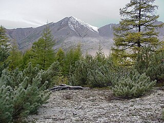
The Kolyma Mountains or Kolyma Upland, is a system of mountain ranges in northeastern Siberia, lying mostly within the Magadan Oblast, along the shores of the Sea of Okhotsk in the Kolyma region. It constitutes the watershed between the basins of Kolyma River and of the Sea of Okhotsk / Pacific Ocean.