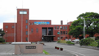
Nemuro is a city and port located in Nemuro Subprefecture, Hokkaido, Japan. It is the capital city of Nemuro Subprefecture. Much of the city lies on the Nemuro Peninsula. As of February 29, 2012, the city has an estimated population of 29,087, with 12,966 households, and a population density of 56.74 persons per km2. The total area is 512.63 km2 (197.93 sq mi).

The Hokkaido Railway Company is one of the constituent companies of the Japan Railways Group, and is often referred to using its official abbreviation of JR Hokkaido. It operates intercity and local rail services in Hokkaido, Japan. The company introduced Kitaca, a smart card ticketing system, in autumn 2008.
Notsuke is a district in Nemuro Subprefecture, Hokkaido, Japan. As of 2004, it has an estimated population of 17,010 and an area of 1,320.15 km2.

Shibetsu is a district located in Nemuro Subprefecture, Hokkaido, Japan. As of 2004, its estimated population is 30,285 with a total area of 1309.44 km2
Nemuro Province was an old province in Japan in what is today Nemuro Subprefecture, Hokkaidō. It was created during the Meiji Era.
Menashi is a district located in Nemuro Subprefecture, Hokkaido, Japan. As of 2010, its population is estimated at 6,069 and its area is 397.88 km2, with a population density of 15.3/km2 The origin of the name "Menashi" comes from the Ainu word menashi, meaning "to the east". The local government in Nemuro, which includes Shiretoko and The Northern Territories, decided to name the whole region "Menashi". Menashi's only town is Rausu. The district was one of the settings of the Menashi-Kunashiri Battle of 1789.

Akkeshi is a town located in Kushiro Subprefecture, Hokkaido. As of June 28th, 2023, it has a population of 8,460, and an area of 734.82 km2. Lake Akkeshi is a Ramsar Site.

Betsukai is a town located in Nemuro Subprefecture, Hokkaido, Japan. As of April 30, 2017, the town has an estimated population of 15,179, and an area of 1,320.15 km2. The town is primarily agricultural, with numerous dairy farms. It comprises a part of the agricultural region referred to as "Milk Land Hokkaido".
Shibetsu is a town located in Nemuro Subprefecture, Hokkaido, Japan. As of September 2016, it has an estimated population of 5,374, and an area of 624.49 km2.

Rausu is a town located in Nemuro Subprefecture, Hokkaido, Japan. As of September 30, 2016, it has an estimated population of 5,395, and an area of 397.88 km2.

Shiretoko Peninsula is located on the easternmost portion of the Japanese island of Hokkaidō, protruding into the Sea of Okhotsk. It is separated from the Russian Kunashir Island by the Nemuro Strait. The name Shiretoko is derived from the Ainu word sir etok, meaning "the end of the Earth" or "the place where the Earth protrudes". The towns of Rausu and Shari are found on the peninsula.
In 1869, the island of Hokkaido, Japan was divided into 11 provinces and 86 districts. The majority of Japan's former provinces were converted into prefectures by the Meiji government between 1870 and 1876.

The Nemuro Peninsula is a peninsula which extends from the east coast of Hokkaidō, Japan. It is some 30 kilometres (19 mi) long and 8 kilometres (5.0 mi) wide, and forms part of Nemuro City. Cape Nosappu at its tip is the easternmost point of Hokkaidō. The northern coastline is on Nemuro Bay, while the south faces the Pacific Ocean. Islands of the Habomai (Khabomai) Archipelago, administered by Russia but claimed by Japan, extend eastward from the peninsula.
Nemuro Strait, also called Notsuke Strait and Kunashirsky Strait, is a strait separating Kunashir Island of the Kuril Islands, Russia from the Shiretoko Peninsula, Hokkaidō, Japan. The strait connects the Sea of Okhotsk in the north to the Izmeny Strait in the south. It is located on the southeastern borders of Sakhalin Oblast, Russia, and Nemuro Subprefecture of Japan. Along the strait runs the border between the two states.

Nemuro Main Line is a railway line in Hokkaido operated by Hokkaido Railway Company, connecting Takikawa Station in Takikawa and Nemuro Station in Nemuro, including Obihiro and Kushiro. Higashi-Nemuro is the most easterly situated station on the Japanese rail system.

Lilium pensylvanicum is an Asian plant species of the family Liliaceae. Sometimes called the Siberian lily, it is native to a cold climate and needs frost in the winter. It is found in the wild form in Siberia, the Russian Far East, Mongolia, northeast China, Korea and Hokkaidō.
Notsuke-Fūren Prefectural Natural Park is a Prefectural Natural Park in eastern Hokkaidō, Japan. Established in 1962, the park spans the municipalities of Betsukai, Nemuro, and Shibetsu. The park comprises two principal areas, the Notsuke peninsula and Lake Furen.

The Hokkaidō Development Commission, sometimes referred to as Hokkaidō Colonization Office or simply Kaitakushi, was a government agency in early Meiji Japan. Tasked with the administration, economic development, and securing of the northern frontier in what, at the time of establishment, was known as Ezo, it was established in 1869 and disbanded in 1882.

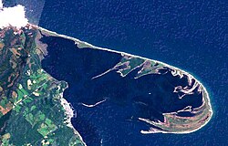
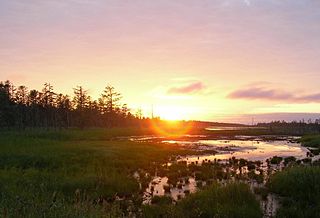
Notsuke Bay is a shallow bay in eastern Hokkaido, Japan, separated from Nemuro Bay and the Sea of Okhotsk by the curving Notsuke Peninsula. The bay mouth has a width of some 4.3 kilometres (2.7 mi) and a maximum depth of 4 metres (13 ft); most of the area of the bay has a depth of less than 1 metre, making it unsuitable for the use of boats with engines. One of the largest seagrass beds in the country, the expanse of eelgrass and kelp makes it an important habitat for marine life, notably Hokkai shrimp, which are harvested in the summer and autumn by utase-bune, with their three-cornered sails. Together with Notsuke Peninsula, by which it is largely enclosed, Notsuke Bay has been designated a Ramsar Site, as a wetland of international importance, a Special Wildlife Protection Area, and an Important Bird Area, and forms part of Notsuke-Fūren Prefectural Natural Park. Water fowl include the grey-tailed tattler, redshank, whooper swan, brent goose, wigeon, scaup, and common goldeneye.