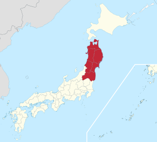
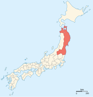
The Tōhoku region, Northeast region, Ōu region, or Northeast Japan consists of the northeastern portion of Honshu, the largest island of Japan. This traditional region consists of six prefectures (ken): Akita, Aomori, Fukushima, Iwate, Miyagi, and Yamagata.

Provinces of Japan were first-level administrative divisions of Japan from the 600s to 1868.

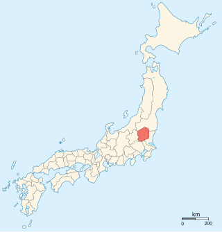
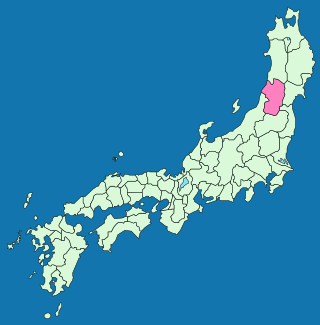
Shinjō is a city in Yamagata Prefecture, Japan. As of 1 January 2020, the city had an estimated population of 34,937, and a population density of 160 persons per km2. The total area of the city is 223.08 km2.
Shimotsuke Province was a province of Japan in the area of Japan that is today Tochigi Prefecture. Shimotsuke was bordered by Kōzuke, Hitachi, Mutsu and Shimōsa Provinces. Its abbreviated form name was Yashū (野州). Under the Engishiki classification system, Shimotsuke was ranked as one of the 13 "great countries" (大国) in terms of importance, and one of the 30 "far countries" (遠国) in terms of distance from the capital. The provincial capital is located in what is now the city of Tochigi. The Ichinomiya of the province is the Futarasan jinja located in what is now the city of Utsunomiya.
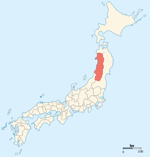
Uzen Province is an old province of Japan in the area of Yamagata Prefecture. It was sometimes called Ushū (羽州), with Ugo Province.
Mutsu Province was an old province of Japan in the area of Fukushima, Miyagi, Iwate and Aomori Prefectures and the municipalities of Kazuno and Kosaka in Akita Prefecture.
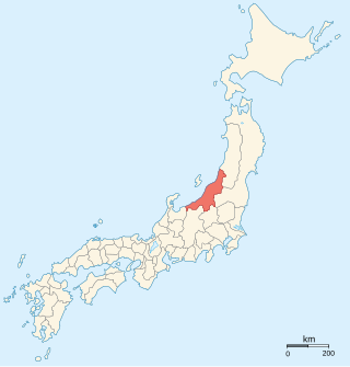
Echigo Province was an old province in north-central Japan, on the shores of the Sea of Japan. It bordered on Uzen, Iwashiro, Kōzuke, Shinano, and Etchū Provinces. It corresponds today to Niigata Prefecture, minus the island of Sado.

Akumi District is a rural district located in Yamagata Prefecture, Japan.

Mogami Yoshiaki was a daimyō of the Yamagata Domain in Dewa Province, in the late Sengoku and early Edo periods. He was known as the "Fox of Dewa".
Shōnai Domain was a feudal domain in Edo period Japan, located in Dewa Province, Japan. It was centered on Tsuruoka Castle in what is now the city of Tsuruoka in Yamagata Prefecture, and was thus also known as the Tsuruoka Domain. It was governed for the whole of its history by the Sakai clan, which resulted in an unusually stable and prosperous domain. During their rule over Shōnai, the Sakai clan was ranked as a province-holding daimyō family, and as such, had the privilege of shogunal audiences in the Great Hall (Ohiroma) of Edo Castle. In the Boshin War of 1868–69, the domain joined the Ōuetsu Reppan Dōmei, the alliance of northern domains supporting the Tokugawa shogunate, but then later defected to the imperial side. As with all other domains, it was disbanded in 1871.

Mogami clan (最上氏) were Japanese daimyōs, and were a branch of the Ashikaga family. In the Sengoku period, they were the Sengoku daimyōs who ruled Dewa Province which is now Yamagata Prefecture and part of Akita Prefecture.

Kaminoyama Domain a feudal domain in Edo period Japan, located in Dewa Province, Japan. It was centered on Kaminoyama Castle in what is now the city of Kaminoyama, Yamagata.
Kameda Domain was a feudal domain in Edo period Japan, located in Dewa Province, Japan. It was centered on Kameda Castle in what is now the city of Yurihonjō, Akita.

Akita Castle refers to the ruins of a Nara period fortified settlement located in what is now the city Akita, Akita Prefecture, Japan. It is also sometimes referred to as “Fort Akita”. The name is sometimes used wrongly for Kubota Castle, an Edo period Japanese castle which served as the headquarters or the Satake, daimyō of Kubota Domain that was a domain in the northern part of Dewa Province created by the Tokugawa shogunate.
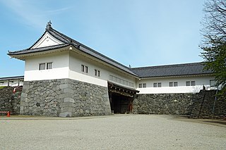
Yamagata Castle is a flatland-style Japanese castle located in the center of the city of Yamagata, eastern Yamagata Prefecture, Japan. Throughout the Edo period, Yamagata Castle was the headquarters for the daimyō of Yamagata Domain. The castle was also known as "Ka-jō" (霞城). The castle grounds are protected as a National Historic Site by the Japanese government
Tozawa clan was a Japanese samurai kin group from Mutsu and Dewa Provinces who ruled as daimyō of Shinjō Domain under the Edo period Tokugawa shogunate. The Tozawa clan residence in Edo was located near the temple of Zōjō-ji.

The Nakayamagoe Pass is a mountain pass in Ōu Mountains on the Dewa Sendai Kaidō, a branch of the Ōshū Kaidō highway, which connected Sendai in what is now Miyagi Prefecture with Sakata in what is now Yamagata Prefecture on the Sea of Japan. It was proclaimed a National Historic Site in 1990.
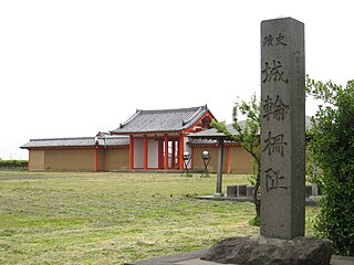
Kiwanosaku was a late Nara period though Heian period josaku-style Japanese castle located in what is now part of the town of Sakata, Yamagata Prefecture in the Tōhoku region of Japan. Its ruins are now an archaeological site and have been protected by the central government as a National Historic Site since 1932.
Oguni Castle was a Nanboku-chō period yamashiro-style Japanese castle located in what is now part of the city of Tsuruoka, Yamagata Prefecture in the Tōhoku region of northern Japan. The site has been protected by the central government as a National Historic Site since 2002. The site is approximately 30 minutes by car from Atsumi Onsen Station on the JR East Uetsu Main Line. It should not be confused with another Oguni Castle in Dewa Province, located in the Mogami region.