Ōmi Province

Last updated • 4 min readFrom Wikipedia, The Free Encyclopedia
Map of Japanese provinces (1868) with Omi Province highlighted Provinces of Japan-Omi.svg
Map of Japanese provinces (1868) with Omi Province highlighted
Ukiyo-e print by Hiroshige of the sailboats at Yahashi, one of the Eight Views of Omi, c. 1834 Hiroshige Boats on a lake.jpg
Ukiyo-e print by Hiroshige of the sailboats at Yahashi, one of the Eight Views of Ōmi , c. 1834

Ōmi Province (近江国, Ōmi no kuni) was a province of Japan, which today comprises Shiga Prefecture. [1] It was one of the provinces that made up the Tōsandō circuit. Its nickname is Gōshū (江州). Under the Engishiki classification system, Ōmi was ranked as one of the 13 "great countries" (大国) in terms of importance, and one of the "near countries" (近国) in terms of distance from the capital.

Contents

Ōmi bordered on Wakasa and Echizen Provinces to the north, Mino and Ise Provinces to the east, Iga and Yamato Provinces to the south, and Yamashiro and Tanba Provinces to the west. Lake Biwa, Japan's largest lake, is located at the center of the province.

History

The area of Ōmi has been settled since at least the Yayoi period, and the traces of several large settlements have been found. During the Kofun period, the area appears to have been dominated by several powerful immigrant clans, most notably the Wani clan, originally from Baekje. The names of "Ōmi" or "Lake Biwa" do not appear in the Kojiki , Man'yōshū or other ancient documents. Ōmi was originally called by various names. Wooden tags from the ruins of Asuka-kyō state "Ahaumi" (淡海), or variations therefore, including "Chikaumi" (近淡海), meaning "fresh-water sea or "nearby freshwater sea", which evolved into or Ōmi-no-umi, (近江海). The name was only fixed to "Ōmi" after the enactment and enforcement of the Taiho Code in 701 AD and the decree of 713 AD that the names of the provinces as defined under the Ritsuryō system should be named using two auspicious kanji .

The Ōmi Ōtsu Palace, located in what is now the city of Ōtsu, and later the Shigaraki Palace in the city of Kōka were briefly the capitals of Japan, and Ōmi was the location of several battles of the Asuka period Jinshin War. During the Nara period, the provincial capital and provincial temple were built in Ōtsu near the ruins of the former Ōmi Ōtsu Palace. Takebe taisha was designated as the chief Shinto shrine ( ichinomiya ) for the province. [2] During the Heian period, then proximity of Ōmi to the capital at Heian-kyō, its location on the Tōkaidō and Nakasendō highways connecting the capital with the provinces of eastern Japan, and the main route from the capital to the Sea of Japan gave the province great strategic importance. With the spread of Buddhism in Japan, the great Tendai monastery of Enryaku-ji was constructed at Mount Hiei in Ōmi.

From the late Heian period and into the Kamakura period, the Sasaki clan controlled the post of shugo of Ōmi Province, and their cadet houses of the Rokkaku clan and Kyōgoku clan continued to dominate the province into the Muromachi period. In the Sengoku period, internal struggles weakened both clans, and Ōmi became a battleground between the Azai and Asakura clans in the north and in the south the Rokkaku were supported by the famous Kōga ninja. In the late 1560s into the 1570s, Oda Nobunaga invaded from the east, defeating the Azai, Asakura, Rokkaku, Kōka, and the Ashikaga shogunate. He built Azuchi Castle near Lake Biwa in Ōmi, from which he planned to eventually rule all of Japan and beyond. Following Nobunaga's assassination, much of the province was awarded by Toyotomi Hideyoshi to Ishida Mitsunari, Tokugawa Ieyasu's opponent at the Battle of Sekigahara.

After the establishment of the Tokugawa Shogunate, much of the province was divided into several feudal domains, then largest of which was Hikone Domain, ruled by the Ii clan. Ōmi continued in its role as a transportation conduit, with five stations of the Tōkaidō and eight stations of the Nakasendō.

Following the Meiji restoration, on November 22, 1871 Ōtsu Prefecture and Nagahama Prefecture were created from former tenryō and hatamoto territories within the province, and each of the former domains formed its own prefecture. These were merged on January 19, 1872 to form Shiga Prefecture. From August 21, 1876 to February 7, 1881 the Reinan region of Fukui Prefecture (west of Tsuruga city) was part of Shiga Prefecture, thus giving it a shoreline on the Sea of Japan. The merger was strongly opposed by the local inhabitants, and the merger was withdrawn.

Historical districts

Districts of Omi province.png

Ōmi was divided into 12 Districts (郡), which were further subdivided into 93 counties (郷), containing 1,597 villages. The total assessed value of the province in terms of kokudaka was 858,618 koku .

Edo-period Domains

List of the domains of Ōmi Province
NameCapitalRuling clan and kokudaka
Hikone Domain Sawayama Castle
(1600- 1606)
Hikone Castle
(1606- 1871)
Ii clan (1600 - 1871, 180,000→150,000→200,000→250,000→300,000 (350,000→200,000→230,000)
Zeze Domain Zeze Castle

Toda clan (1601 - 1616, 30,000 koku)
Honda clan (1616 - 1621, 30,000 koku)
Suganuma clan (1621-1634, 31,000 koku)
Ishikawa clan (1634 - 1651, 70,000→ 53,000 koku)
Honda clan (1651 - 1871 , 70,000 koku)

Minakuchi Domain Minakuchi Castle

Kato clan (1682 - 1695, 20,000 koku)
Torii clan (1695 - 1712, 20,000 koku)
Kato clan (1712 - 1871, 25,000 koku)

Ōmizo Domain Ōmizo jin'ya

Wakebe clan (1619- 1871, 20,000 koku)

Nisshōji Domain Nisshōji jin'ya

Ichihashi clan (1620 - 1871, 20,000→18,000→17,000 koku)

Yamakami Domain Yamakami jin'ya

Ando clan (1604 - 1695, 10,000 koku)
Inagaki clan, (1698 - 1871, 13,000 koku)

Ōmi-Miyagawa Domain Miyagawa jin'ya

Hotta clan (1698 - 1871, 10,000→13,000)

Mikami Domain Mikami jinya

Endo clan (1698 - 1870, 10,000→12,000 koku)

Katata Domain Katata jin'ya

Hotta clan (1698 - 1826, 10,000→13,000 koku)
Transferred to Shimotsuke Sano Domain

Kutsuki Domain Kutsuki jin'ya

Kutsuki clan (1636 - 1648, 10,000 koku)
transferred to Shimotsuke Kanuma Domain

Ōmori Domain Ōmori jin'ya

Mogami clan (1622 - 1632, 10,000 koku)
attainder

Ōmi-Takashima Domain

Sakuma clan (1600 - 1616, 15,000→20,000 koku)
transfer to Shinano Iiyama domain, later attainder

Ōmi-Komuro Domain Komuro jin'ya

Kobori clan (1619 -1788, 12,460→11,460→16,300 koku)
attainder due to mismanagement

Notes

Related Research Articles

<span class="mw-page-title-main">Owari Province</span> Former province of Japan

Owari Province was a province of Japan in the area that today forms the western half of Aichi Prefecture, including the modern city of Nagoya. The province was created in 646. Owari bordered on Mikawa, Mino, and Ise Provinces. Owari and Mino provinces were separated by the Sakai River, which means "border river." The province's abbreviated name was Bishū (尾州).

<span class="mw-page-title-main">Shiga Prefecture</span> Prefecture of Japan

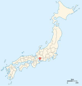
Shiga Prefecture is a landlocked prefecture of Japan located in the Kansai region of Honshu. Shiga Prefecture has a population of 1,412,916 and has a geographic area of 4,017 km2 (1,551 sq mi). Shiga Prefecture borders Fukui Prefecture to the north, Gifu Prefecture to the northeast, Mie Prefecture to the southeast, and Kyoto Prefecture to the west.

<span class="mw-page-title-main">Hikone, Shiga</span> City in Kansai, Japan

Hikone is a city located in Shiga Prefecture, Japan. As of 1 August 2021, the city had an estimated population of 111,958 in 49066 households and a population density of 570 persons per km². The total area of the city is 196.84 square kilometres (76.00 sq mi).

<span class="mw-page-title-main">Moriyama, Shiga</span> City in Kansai, Japan

Moriyama is a city located in Shiga Prefecture, Japan. As of 31 August 2021, the city had an estimated population of 85,485 in 34366 households and a population density of 1533.63 persons per km². The total area of the city is 55.74 square kilometres (21.52 sq mi).

<span class="mw-page-title-main">Kai Province</span> Former province of Japan

Kai Province was a province of Japan in the area of Japan that is today Yamanashi Prefecture. Kai bordered on Sagami, Suruga, Shinano and Musashi Provinces. Its abbreviated form name was Kōshū (甲州). The origin of its name is uncertain. It lies in central Honshū, west of Tokyo, in a landlocked mountainous region that includes Mount Fuji along its border with modern Shizuoka Prefecture.

<span class="mw-page-title-main">Mikawa Province</span> Former province of Japan

Mikawa Province was an old province in the area that today forms the eastern half of Aichi Prefecture. Its abbreviated form name was Sanshū. Mikawa bordered on Owari, Mino, Shinano, and Tōtōmi Provinces.

<span class="mw-page-title-main">Iga Province</span> Former province of Japan

Iga Province was a province of Japan located in what is today part of western Mie Prefecture. Its abbreviated name was Ishū (伊州). Iga is classified as one of the provinces of the Tōkaidō. Under the Engishiki classification system, Iga was ranked as an "inferior country" and a "near country".

<span class="mw-page-title-main">Maibara, Shiga</span> City in Kansai, Japan

Maibara is a city in Shiga Prefecture, Japan. As of 1 September 2021, the city had an estimated population of 38,259 in 14761 households and a population density of 150 persons per km². The total area of the city is 250.39 square kilometres (96.68 sq mi).

<span class="mw-page-title-main">Azai clan</span>

The Azai clan, also rendered as Asai, was a Japanese clan during the Sengoku period.

<span class="mw-page-title-main">Ōtsu</span> Core city in Kansai

Ōtsu is the capital city of Shiga Prefecture, Japan. As of 1 October 2021, the city had an estimated population of 343,991 in 153,458 households and a population density of 740 persons per km2. The total area of the city is 464.51 square kilometres (179.35 sq mi).

<span class="mw-page-title-main">Ōtsu-juku</span> Last station of the Tōkaidō and the Nakasendō

Ōtsu-juku was the last of the sixty-nine stations of the Nakasendō, as well as the last of the fifty-three stations of the Tōkaidō. It was 14 km (9 mi) from the previous post town, Kusatsu-juku, and was located in Ōmi Province. It is currently located in the present-day city of Ōtsu, Shiga Prefecture, Japan.

<span class="mw-page-title-main">Echigawa-juku</span> Pre-modern Japan post-station along highway

Echigawa-juku (愛知川宿) was the sixty-fifth of the sixty-nine stations of the Nakasendō highway connecting Edo with Kyoto in Edo period Japan. It was located in the present-day town of Aishō, Echi District, Shiga Prefecture, Japan, on the east side of the Echi River.

<span class="mw-page-title-main">Banba-juku</span> Pre-modern Japan post-station along highway

Banba-juku was the sixty-second of the sixty-nine stations of the Nakasendō highway connecting Edo with Kyoto in Edo period Japan. It was located in the present-day city of Maibara, Shiga Prefecture, Japan.

<span class="mw-page-title-main">Samegai-juku</span> Pre-modern Japan post-station along highway

Samegai-juku was the sixty-first of the sixty-nine stations of the Nakasendō highway connecting Edo with Kyoto in Edo period Japan. It was located in the present-day city of Maibara, Shiga Prefecture, Japan.

<span class="mw-page-title-main">Musa-juku</span> Pre-modern Japan post-station along highway

Musa-juku (武佐宿) was the sixty-sixth of the sixty-nine stations of the Nakasendō highway connecting Edo with Kyoto in Edo period Japan. It was located in the present-day city of Ōmihachiman, Shiga Prefecture, Japan. Other kanji used to write "Musa" included 牟佐 and 身狭, but 武佐 became the official kanji in the Edo period.

<span class="mw-page-title-main">Nishiazai District, Shiga</span>

Nishiazai was a district located in Shiga Prefecture. The district is equivalent to the town of Nishiazai in Ika District.

<span class="mw-page-title-main">Kannonji Castle</span> Japanese castle

Kannonji Castle was a Sengoku period yamashiro-style Japanese castle located in what is now the Azuchi neighborhood of the city of Ōmihachiman, Shiga Prefecture, Japan. The ruins have been protected as a National Historic Site since 1982, with the area under protection expanded in 1984. The castle was named after Kannonshō-ji, a Buddhist temple near the peak of the mountain.

<span class="mw-page-title-main">Zeze Domain</span>

Zeze Domain was a fudai feudal domain under the Tokugawa shogunate of Edo period Japan. It was located in southern Ōmi Province, in the Kansai region of central Honshu. The domain was centered at Zeze Castle, located on the shore of Lake Biwa in what is now the city of Ōtsu in Shiga Prefecture.

<span class="mw-page-title-main">Azai District, Ōmi</span>

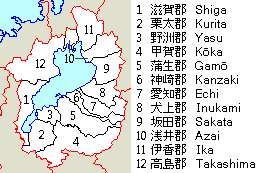
Azai was a district located in Ōmi Province/Shiga Prefecture.

References

Other websites

Commons-logo.svg Media related to Omi Province at Wikimedia Commons