Hokkaido is Japan's second largest island and comprises the largest and northernmost prefecture, making up its own region. The Tsugaru Strait separates Hokkaidō from Honshu; the two islands are connected by the undersea railway Seikan Tunnel.

Sorachi Subprefecture is a subprefecture of Hokkaido Prefecture, Japan. As of 2004, its estimated population is 373,736 and its area is 6,558.26 km2.

Yūbari is a city located in Sorachi Subprefecture, Hokkaido, Japan.
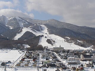
Furano is a city in the prefecture of Hokkaido, Japan, located in the southern reaches of Kamikawa Subprefecture, under whose jurisdiction it resides. Well known throughout Japan as a tourism destination, it is famous for its lavender fields, the television drama Kita no Kuni kara and the Furano Ski Resort, which held the Snowboarding World Cup in recent years. As of September 2016, the city has an estimated population of 22,715 and a density of 38 persons per km2. The total area is 600.97 km2 (232.04 sq mi).

Sorachi is a district divided between Sorachi and Kamikawa Subprefectures, Hokkaido, Japan. As of 2004, the district has an estimated population of 53,011 and an area of 1,497.21 km2, giving a population density of 35.41 persons per square kilometer.

Sapporo Station is a railway station in Chūō-ku, Sapporo, Hokkaido, Japan. It is served by Hakodate Main Line and other lines of Hokkaido Railway Company, and is also connected to the Subway Sapporo Station.
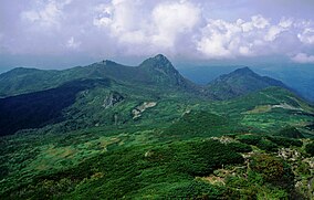
Yūbari Mountains is a mountain range of Hokkaidō, Japan.

Asahikawa Station is a railway station in Asahikawa, Hokkaido, Japan, operated by the Hokkaido Railway Company.

National Route 38 is a national highway connecting Takikawa and Kushiro in Hokkaidō, Japan.

Furano Station is a railway station in Furano, Hokkaido, Japan, operated by the Hokkaido Railway Company. The station is numbered T30.

Ashibetsu Station is a railway station on the Nemuro Main Line of JR Hokkaido located in Ashibetsu, Hokkaidō, Japan. The station opened on November 10, 1913.

Kami-Ashibetsu Station is a railway station on the Nemuro Main Line of JR Hokkaido located in Ashibetsu, Hokkaidō, Japan. The station opened on January 16, 1920.

Nokanan Station is a railway station on the Nemuro Main Line of JR Hokkaido located in Ashibetsu, Hokkaidō, Japan. The station opened on November 10, 1913.
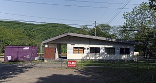
Shimanoshita Station was a railway station on the Nemuro Main Line of JR Hokkaido located in Furano, Hokkaidō, Japan. The station opened on November 10, 1913. This station was permanently closed by the Hokkaido Railway Company on March 3, 2017

Nunobe Station is a railway station on the Nemuro Main Line of JR Hokkaido located in Furano, Hokkaidō, Japan. The station opened on December 26, 1927.

Yamabe Station is a railway station of the JR Hokkaido Nemuro Main Line located in Furano, Hokkaidō, Japan. It opened on December 2, 1900.

The Ashibetsu Dam is a dam in Ashibetsu, Hokkaidō, Japan, completed in 1952.

Furano Ski Resort, also known as Furano Ski Area, is a resort in Furano, Hokkaido, Japan, owned and operated by Prince Hotels. The resort became famous for its long-standing relationship with the FIS Alpine Ski World Cup. In more recent years, it has held the mid-February Snowboarding World Cup, sponsored by Dydo Drinco. Recently, there has been a sudden influx of interest from winter sports enthusiasts abroad, particularly from Australia, and the number of tourists has increased every year.

Mount Ashibetsu is a mountain located on the border between Ashibetsu and Furano, Hokkaidō, Japan. It is part of the Yūbari Mountains.

The island of Hokkaidō is located in the north of Japan, near Russia. It has coastlines on the Sea of Japan, the Sea of Okhotsk, and the Pacific Ocean. The center of the island is mountainous, with volcanic plateaux. Hokkaidō has multiple plains such as the Ishikari Plain 3,800 km2 (1,500 sq mi), Tokachi Plain 3,600 km2 (1,400 sq mi), the Kushiro Plain 2,510 km2 (970 sq mi) and Sarobetsu Plain 200 km2 (77 sq mi). Hokkaidō is 83,423.84 km2 (32,210.12 sq mi) which makes it the second-largest island of Japan.