List of provinces
The former provinces of Hokkaido are listed below with their districts.
Oshima Province

Oshima Province (渡島国, Oshima-no kuni): [2] Presently the southern part of modern-day Oshima and Hiyama Subprefectures. Districts included:
Shiribeshi Province

Shiribeshi Province (後志国, Shiribeshi-no kuni): [2] Modern-day Shiribeshi Subprefecture (minus Abuta) plus northern Hiyama. Districts included:
- Kudō (久遠郡)
- Okushiri (奥尻郡)
- Futoru (太櫓郡) – dissolved on April 1, 1955 when Futoru Village merged with Tōsetana Town (from Setana District) to create Kitahiyama Town
- Setana (瀬棚郡)
- Shimamake (島牧郡)
- Suttsu (寿都郡)
- Utasutsu (歌棄郡) – dissolved on January 15, 1955 when Utasutsu Village was incorporated into Suttsu Town (in Suttsu District); Neppu Village was merged with Suttsu District's Kuromatsunai Village and part of Tarukishi Village to create Sanwa Village (now Kuromatsunai Town)
- Isoya (磯屋郡, later respelled 磯谷郡)
- Iwanai (岩内郡)
- Furuu (古宇郡)
- Shakotan (積丹郡)
- Bikuni (美国郡) – dissolved September 30, 1956 when Bikuni Town was incorporated into Shakotan Town, Shakotan District.
- Furubira (古平郡)
- Yoichi (余市郡)
- Oshiyoro (忍路郡) – dissolved on April 1, 1958 when Shioya? Village was incorporated into Otaru City
- Takashima (高島郡) – dissolved on September 1, 1940 when Takashima Town was incorporated into Otaru
- Otaru (小樽郡) – dissolved on September 1, 1940 when Asato? Village was incorporated into Otaru
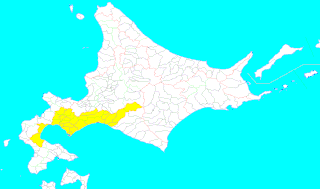
Iburi Province

Iburi Province (胆振国, Iburi-no kuni): [2] Modern-day Iburi Subprefecture, Yamakoshi District of Oshima, Abuta District of Shiribeshi, the cities of Chitose and Eniwa of Ishikari, and Shimukappu Village of Kamikawa. Districts included:
- Yamakoshi (山越郡)
- Abuta District (虻田郡)
- Usu (有珠郡)
- Muroran (室蘭郡) – dissolved on February 1, 1918 when four towns and villages merged to create Muroran-ku
- Yoribetsu (幌別郡) – dissolved on August 1, 1970 when Noboribetsu Town became Noboribetsu City
- Shiraoi (白老郡)
- Yūfutsu (勇払郡)
- Chitose (千歳郡) – dissolved on November 11, 1970 when Eniwa Town became a city
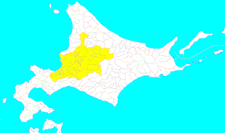
Ishikari Province

Ishikari Province (石狩国, Ishikari-no kuni): [2] Modern-day Ishikari Subprefecture minus Chitose and Eniwa, all of Sorachi Subprefecture, and the southern half of Kamikawa Subprefecture (including Horokanai and excluding Shimukappu). Districts included:
Teshio Province

Teshio Province (天塩国, Teshio-no kuni): [2] Presently all of modern-day Rumoi Subprefecture and the northern half of Kamikawa Subprefecture. Districts included:
Kitami Province

Kitami Province (北見国, Kitami no kuni): [2] Modern-day Sōya Subprefecture and Abashiri Subprefecture minus part of Abashiri District. Districts included:
Hidaka Province

Hidaka Province (日高国, Hideka-no kuni): [2] Modern-day Hidaka Subprefecture. Districts included:
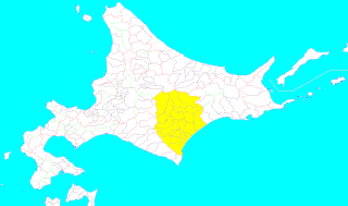
Tokachi Province

Tokachi Province (十勝国, Tokachi-no kuni): [2] Modern-day Tokachi Subprefecture. Districts included:
Kushiro Province

Kushiro Province (釧路国, Kushiro-no kuni): [2] Modern-day Kushiro Subprefecture and part of Abashiri Subprefecture. Districts included:
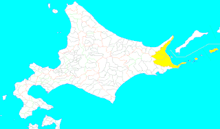
Nemuro Province

Nemuro Province (根室国, Nemuro-no kuni): [2] Presently the mainland portion of modern-day Nemuro Subprefecture plus Habomai Rocks and Shikotan Island. Districts included:
Chishima Province

Chishima Province (千島国, Chismima-no kuni): [2] Originally the islands of Kunashiri and Etorofu, later included Shikotan and the Kuril Islands. Districts included:
- Kunashiri (国後郡) – occupied and administered by Russia (see Kuril Islands dispute)
- Etorofu (択捉郡) – occupied and administered by Russia
- Furebetsu (振別郡) – dissolved in April 1923 when its villages merged with several villages in Shana and Etorofu Districts to create the village of Rubetsu (in Etorofu)
- Shana (紗那郡) – occupied and administered by Russia
- Shibetoro (蘂取郡) – occupied and administered by Russia
- Shikotan (色丹郡) – split off from Hanasaki District in 1885; currently occupied and administered by Russia
- Uruppu (得撫郡) – acquired in Treaty of Saint Petersburg (1875); ceded in San Francisco Treaty
- Shimushiru (新知郡) – acquired in Treaty of Saint Petersburg; ceded in San Francisco Treaty
- Shumushu (占守郡) – acquired in Treaty of Saint Petersburg; ceded in San Francisco Treaty
Karafuto

Karafuto Region was the area of Sakhalin south of the border established by the 1875 Treaty of Saint Petersburg between Japan and Russia. [3] After the 1905 Treaty of Portsmouth, Karafuto was administered from Toyohara in Karafuto Prefecture.