1918 Celebes Sea earthquake

Last updated

1918 Celebes Sea earthquake
Philippines relief location map (square).svg
Bullseye1.png
UTC  time1918-08-15 12:18:21
ISC  event 913230
USGS-ANSS ComCat
Local dateAugust 15, 1918 (1918-08-15)
Local time20:18
Duration>3 minutes [1]
Magnitude8.3 Mw [2]
Depth20 km (12 mi) [2]
Epicenter 5°32′17″N123°59′38″E / 5.538°N 123.994°E / 5.538; 123.994 [2]
Max. intensity MMI X (Extreme)
TsunamiYes
Casualties52
The Cotabato Trench in southern Mindanao and the Philippine Mobile Belt. Tectonic map of Philippines.png
The Cotabato Trench in southern Mindanao and the Philippine Mobile Belt.
Philippines location map (Mindanao).svg
Red pog.svg
1976
Red pog.svg
1918
Red pog.svg
2002
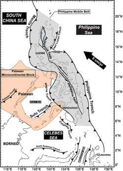
Near the Cotabato Trench, two of the largest 20th century Philippine earthquakes: the 1918 Celebes Sea earthquake (8.3 Mw) and the 1976 Moro Gulf earthquake (8.0 Mw). Also included is the recent 2002 Mindanao earthquake (7.5 Mw). The Moro Gulf, part of the Celebes Sea, is labeled for context.

The 1918 Celebes Sea earthquake occurred on August 15 at 12:18 UTC near the Moro Gulf coast of Mindanao. [1] It had a magnitude of 8.3 on the moment magnitude scale [3] and a maximum perceived intensity of X (Extreme) on the Mercalli intensity scale. It triggered a tsunami of up to 7 m in height and the combined effects of the earthquake and tsunami led to the deaths of 52 people.

Contents

Tectonic setting

The southwestern part of Mindanao sits above a geologically young subduction zone, where the section of the Sunda Plate that lies beneath the Celebes Sea is subducting beneath the Philippines Mobile Belt along the line of the Cotabato Trench. The presence of the Cotabato subduction zone was confirmed by observations from the 1976 Moro Gulf earthquake. [4] [5]

Earthquake

The earthquake had a magnitude of 8.3 on the Moment magnitude scale, it had an estimated depth of 20 kilometers. The earthquake was 75 kilometers South southwest of Palimbang, Sultan Kudarat. [2] A station at Butuan in northern Mindanao registered over 600 aftershocks before the end of August, with 250 recorded by the end of August 16. [1] [6]

The earthquake has been associated with rupture along the active east-dipping Cotabato Trench subduction zone beneath Mindanao. [4] The epicenter is interpreted to be in the same part of the plate interface as the 1976 Moro Gulf event. The distribution of effects suggests that fault rupture extended for 200 km along the coast. The average slip is estimated to be 4.1 m. [7]

Tsunami

This event in the southern Philippines triggered a large tsunami, with a maximum run-up of 7.2 m, [8] which affected the coasts of the Celebes Sea, causing widespread damage. The combined effects of the earthquake and the tsunami caused 52 casualties. With some sources stating that the tsunami alone caused up to 1,000 casualties. [9] [ better source needed ]

Damage

The earthquake caused widespread damage in the coastal parts of southwestern Mindanao, with all houses destroyed around Sarangani Bay. The effects of the earthquake were compounded by the tsunami that particularly affected 150 km of coast between Lebak and Glan. A major landslide was also reported from one of the mountains around Saragani Bay. [1]

The number of casualties is uncertain as there is no definitive total. [7] Several sources refer to 52 deaths. [1]

The estimated losses were up to 5-25 million dollars. There was damage to a stone bridge at Paleleh, Central Sulawesi. [6]

See also

Related Research Articles

<span class="mw-page-title-main">1976 Moro Gulf earthquake</span> Earthquake in the Philippines

The 1976 Moro Gulf earthquake and tsunami occurred on August 17, 1976, at 00:11 local time near the islands of Mindanao and Sulu, in the Philippines. It measured 8.0 on the moment magnitude scale occurring at a depth of 20 km (12 mi). The earthquake was accompanied by a destructive tsunami that resulted in a majority of the estimated 5,000 to 8,000 fatalities. It was the deadliest and strongest earthquake in the Philippines in 58 years since the 1918 Celebes Sea earthquake.

<span class="mw-page-title-main">Lists of 20th-century earthquakes</span>

This list of 20th-century earthquakes is a list of earthquakes of magnitude 6 and above that occurred in the 20th century. Sone smaller events which nevertheless had a significant impact are also included. After 1900 most earthquakes have some degree of instrumental records and this means that the locations and magnitudes are more reliable than for earlier events.

<span class="mw-page-title-main">2002 Mindanao earthquake</span> M-7.5 earthquake in Philippines

The 2002 Mindanao earthquake struck the Philippines at 05:16 Philippine Standard Time on March 6. The world's sixth most powerful earthquake of the year, it registered a magnitude of 7.5 and was a megathrust earthquake. It originated near the Cotabato Trench, a zone of deformation situated between the Philippine Sea Plate and the Sunda Plate, and occurred very near to the Philippines' strongest earthquake for the 20th century, the 1918 Celebes Sea earthquake.

The 2010 Mindanao earthquakes occurred in the southern Philippines in the Moro Gulf. This was a complex sequence of events including three main events of Mw magnitude 7.3 or greater on the 23rd of July, and two significant aftershocks of magnitude 6.6 on the 24th and 29th. All of these were deep focus earthquakes, at depths from 565 km (351 mi) to 634 km (394 mi). This resulted in minimal, but very widespread shaking at the surface, with a maximum intensity of IV on the PEIS scale; consequently there were no reports of casualties or damage.

The 1881 Nicobar Islands earthquake occurred at about 07:49 local time on 31 December, with an epicentre beneath Car Nicobar. It occurred as two separate ruptures, the largest of which had an estimated magnitude of 7.9 on the moment magnitude scale and triggered a tsunami that was observed around the Bay of Bengal. It is probably the earliest earthquake for which rupture parameters have been estimated instrumentally.

<span class="mw-page-title-main">1944 Tōnankai earthquake</span> Earthquake and tsunami affecting southern Japan

The 1944 Tōnankai earthquake occurred at 13:35 local time on 7 December. It had an estimated magnitude of 8.1 on the moment magnitude scale and a maximum felt intensity of greater than 5 Shindo. It triggered a large tsunami that caused serious damage along the coast of Wakayama Prefecture and the Tōkai region. Together, the earthquake and tsunami caused 3,358 casualties.

The 1968 Hyūga-nada earthquake occurred on April 1 at 09:42 local time. The earthquake had a magnitude of Mw 7.5, and the epicenter was located in Hyūga-nada Sea, off the islands of Kyushu and Shikoku, Japan. The magnitude of this earthquake was also given as MJMA 7.5. A tsunami was observed. One person was killed, and 22 people were reported injured. The intensity reached shindo 5 in Miyazaki and Kōchi.

The 1762 Arakan earthquake occurred at about 17:00 local time on 2 April, with an epicentre somewhere along the coast from Chittagong to Arakan in modern Myanmar. It had an estimated moment magnitude between 8.5 and 8.8 and a maximum estimated intensity of XI (Extreme). It triggered a local tsunami in the Bay of Bengal and caused at least 200 deaths. The earthquake was associated with major areas of both uplift and subsidence. It is also associated with a change in course of the Brahmaputra River to from east of Dhaka to 150 kilometres (93 mi) to the west via the Jamuna River.

The 1941 Andaman Islands earthquake struck the Andaman Islands on June 26 with a magnitude of 7.7 to 8.1. Details of this event are poorly known as much of Southeast Asia was in the turmoil of World War II. The quake caused severe damage in the Andaman Islands. The tsunami it triggered was reported along the Andaman and Nicobar Islands, India and British Ceylon. There may have been damage and deaths in Bangladesh, Myanmar, and Thailand due to the tsunami.

The 1897 Mindanao earthquakes occurred on September 20, 1897, at 19:06 UTC and September 21, 1897, at 05:12 UTC. The estimated epicentres of the two earthquakes are identical, lying just off the southwestern coast of Mindanao in the Philippines, south of Basilan island. The earthquakes were originally given estimated magnitudes of 8.6 and 8.7 on the surface wave magnitude scale by Charles Richter, but these were revised downwards by Katsuyuki Abe to 7.4 and 7.5 Ms, respectively. Contemporary reports noted that with few exceptions, all the masonry buildings in Zamboanga and Basilan were left in ruins.

The Cotabato Trench is an oceanic trench in the Pacific Ocean, off the southwestern coast of Mindanao in the Philippines. Along this trench the oceanic crust of the Sunda Plate beneath the Celebes Sea is being subducted beneath the Philippines Mobile Belt. It forms part of a linked set of trenches along the western side of the Philippines formed over east-dipping subduction zones, including the Manila Trench and the Negros Trench. At its northern end the rate of convergence across this boundary is about 100 mm per year. It is a relatively young structure, forming during the late Miocene to Pliocene. This age is consistent with the estimated age of the sedimentary rocks in the accretionary wedge associated with the trench and the age of adakitic arc rocks on Mindanao thought to date the onset of subduction.

During April 1819, the area around Copiapó in northern Chile was struck by a sequence of earthquakes over a period of several days. The largest of these earthquakes occurred on 11 April at about 15:00 local time, with an estimated magnitude of Mw 8.5. The other two events, on 3 April between 08:00 and 09:00 local time and on 4 April at 16:00 local time, are interpreted as foreshocks to the mainshock on 11 April. The mainshock triggered a tsunami that affected 800 km of coastline and was also recorded at Hawaii. The city of Copiapó was devastated.

The 1979 Yapen earthquake occurred on September 12 at 05:17:51 UTC. It had an epicenter near the coast of Yapen Island in Irian Jaya, Indonesia. Measuring 7.5 on the moment magnitude scale and having a depth of 20 km (12 mi), it caused severe damage on the island. At least 115 were killed due to shaking and a moderate tsunami.

<span class="mw-page-title-main">1861 Eliki earthquake</span> Major Greek earthquake centred near Gulf of Corinth

The southern margin of the Gulf of Corinth was struck by a major earthquake on 26 December 1861 at 08:28 a.m. local time. It had an estimated magnitude in the range 6.6–6.7 Mw and a maximum felt intensity of IX (destructive) on the European macroseismic scale (EMS). It caused widespread damage on both sides of the Gulf and led to up to 20 deaths and a further 126 people being injured, 18 of them seriously. A series of tsunami waves were reported, with a maximum run-up of 2.1 m.

A Mw  7.9 earthquake struck offshore between Mindanao and Sulawesi on 14 March 1913. It had a maximum Modified Mercalli intensity of IX (Violent). A majority of the 138 fatalities occurred on Sangihe Island attributed to a mudflow.

References

  1. 1 2 3 4 5 National Geophysical Data Center / World Data Service (NGDC/WDS): NCEI/WDS Global Significant Earthquake Database. NOAA National Centers for Environmental Information. "Significant Earthquake Information". Significant Earthquake Database. doi:10.7289/V5TD9V7K . Retrieved June 28, 2024.
  2. 1 2 3 4 "M 8.3 - 75 km SSW of Malisbeng, Philippines". United States Geological Survey. August 15, 1918. Retrieved August 27, 2017.
  3. ISC (June 27, 2015), ISC-GEM Global Instrumental Earthquake Catalogue (1900–2009), Version 2.0, International Seismological Centre
  4. 1 2 Stewart, G.S.; Cohn, S.N. (1979). "The 1976 August 16, Mindanao , Philippine earthquake (Ms = 7.8) - evidence for a subduction zone south of Mindanao". Geophysical Journal of the Royal Astronomical Society. 57 (1): 51–65. Bibcode:1979GeoJ...57...51S. CiteSeerX   10.1.1.926.8672 . doi:10.1111/j.1365-246X.1979.tb03771.x.
  5. Beck, Susan L.; Ruff, Larry. J. (1985). "The rupture process of the 1976 Mindanao Earthquake". Journal of Geophysical Research: Solid Earth. 90 (B8): 6773–6782. Bibcode:1985JGR....90.6773B. doi:10.1029/JB090iB08p06773.
  6. 1 2 "Major mag. 8.3 Earthquake - Celebes Sea, 143 km southwest of Koronadal, Philippines, on Thursday, Aug 15, 1918, at 12:18 pm (Universal Time time)". volcanodiscovery.com. Retrieved June 19, 2024.
  7. 1 2 Okal, E.A.; Synolakis, C.E.; Kalligeris, N. (2011). "Tsunami Simulations for Regional Sources in the South China and Adjoining Seas". Pure and Applied Geophysics. 168: 1153–1173. doi:10.1007/s00024-010-0230-x.
  8. National Geophysical Data Center / World Data Service: NCEI/WDS Global Historical Tsunami Database. NOAA National Centers for Environmental Information. "Tsunami Event Information". doi:10.7289/V5PN93H7 . Retrieved June 28, 2024.
  9. Andrew (December 11, 2022). "The Philippines vs The Pacific Ring of Fire". Naked Expat. Retrieved June 19, 2024.