
The Philippine Institute of Volcanology and Seismology is a Philippine national institution dedicated to provide information on the activities of volcanoes, earthquakes, and tsunamis, as well as other specialized information and services primarily for the protection of life and property and in support of economic, productivity, and sustainable development. It is one of the service agencies of the Department of Science and Technology.
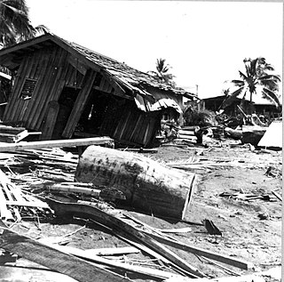
The 1976 Moro Gulf earthquake and tsunami occurred on near the islands of Mindanao and Sulu, in the Philippines. It measured 8.0 on the moment magnitude scale occurring at a depth of 20 km (12 mi). The earthquake was accompanied by a destructive tsunami that resulted in a majority of the estimated 5,000 to 8,000 fatalities. It was the deadliest and strongest earthquake in the Philippines in 58 years since the 1918 Celebes Sea earthquake.
The 2012 Negros earthquake occurred on February 6 at , with a body wave magnitude of 6.7 and a maximum intensity of VII (Destructive) off the coast of Negros Oriental, Philippines. The epicenter of the thrust fault earthquake was approximately 72 kilometres (45 mi) north of Negros Oriental's provincial capital, Dumaguete.
The 1935 Helena earthquake occurred at in Montana, with an epicenter near Helena. It had a magnitude of 6.2 on the surface-wave magnitude scale and a maximum perceived intensity of VIII (Severe) on the Mercalli intensity scale. The temblor on that date was the largest of a series of earthquakes that also included a large aftershock on October 31 of magnitude 6.0 and a maximum intensity of VIII. Two people died in the mainshock and two others died as a result of the October 31 aftershock. Property damage was over $4 million.

The 1918 Celebes Sea earthquake occurred on August 15 at 12:18 UTC near the Moro Gulf coast of Mindanao. It had a magnitude of 8.3 on the moment magnitude scale and a maximum perceived intensity of X (Extreme) on the Mercalli intensity scale. It triggered a tsunami of up to 7 m in height and the combined effects of the earthquake and tsunami led to the deaths of 52 people.
The 2017 Surigao earthquake occurred on February 10, 2017, at 10:03 PM (PST), with a surface-wave magnitude of 6.7 off the coast of Surigao del Norte in the Philippines. According to the PHIVOLCS earthquake intensity scale the earthquake was an Intensity VII (Destructive) earthquake at maximum. In the past Surigao province has been hit by a magnitude 7.2 tremor in both 1879 and 1893.
On July 6, 2017, a 6.5 magnitude earthquake hit Leyte, causing at least 4 deaths and 100 injuries. The quake also caused power interruptions in the whole of Eastern Visayas and nearby Bohol.
On December 12, 1999, a 7.3 earthquake struck the northern coast of Zambales in the Philippines. It was felt in various provinces on the island of Luzon including as far north as Ilocos Norte and as far south as Quezon. This is the second earthquake with a magnitude of 7 to hit the area in 10 years with a 7.7 earthquake having occurred in 1990 which killed more than 2,000 people.
The 2019 Cotabato earthquakes were an earthquake swarm which struck the province of Cotabato on the island of Mindanao in the Philippines in October 2019. Three of these earthquakes were above 6.0 on the moment magnitude scale with a Mercalli intensity of VIII. More than 40 people have been reported dead or missing and nearly 800 were injured as a result of these events.
At 14:11 PST on December 15, 2019, the province of Davao del Sur on the island of Mindanao in the Philippines was struck by an earthquake measuring 6.8 . It had a maximum perceived intensity of VII on the Modified Mercalli Intensity Scale. At least 13 people were killed and another 210 injured.
The Nemuro-Oki earthquake in scientific literature, occurred on June 17 at 12:55 local time. It struck with an epicenter just off the Nemuro Peninsula in northern Hokkaidō, Japan. It measured 7.8–7.9 on the moment magnitude scale (Mw ), 8.1 on the tsunami magnitude scale (Mt ) and 7.4 on the Japan Meteorological Agency magnitude scale (MJMA ).

The 1990 Panay earthquake occurred at 3:41 p.m. local time on 14 June 1990 with a moment magnitude of 7.1, leaving eight dead and 41 others injured. The epicenter was located at Culasi, Antique on Panay Island in the Philippines. The depth was computed to be 15 kilometers. It was generated by fault movement in the collisional zone off western Panay Island.
The 1990 Bohol earthquake occurred on February 8, 1990, at 15:15:32 which had a magnitude of 6.8 Mw . The earthquake had a moderate depth of 25.9 km (16 mi). Most of the damage was observed in the province of Bohol. A tsunami hit the southeastern coastline of Bohol and the island of Camiguin. There were 6 deaths, over 200 injuries and an estimated ₱157 million in total damage reported.
On 9 July 2019, at 8:36 PM (PST), an earthquake measuring 5.6 jolted the province of North Cotabato, Davao del Sur, and other nearby provinces. The National Disaster Risk Reduction and Management Council reported one dead and three injured in Makilala after the earthquake, and a total of 164 families affected in Cotabato Province. Near the epicenter of the earthquake, the severity of strong ground motion was assigned VI (Strong) on the Modified Mercalli intensity scale. A total of 106 schools, 119 houses, and 14 other infrastructures were damaged by the earthquake.
On February 7, 2021, at 12:22 PM PST, an earthquake measuring Mww 6.0 struck Davao del Sur and Cotabato. The event registered a Modified Mercalli Intensity Scale (MMI) of VIII (Severe) with VII on the PHIVOLCS Earthquake Intensity Scale (PEIS).
On August 12, 2021, at 01:46:12 PST, a strong Mw 7.1 earthquake struck the island of Mindanao at a depth of 55.1 kilometers (34.2 mi). It had a maximum perceived Intensity V on the PHIVOLCS Earthquake Intensity Scale. No damage or injuries were reported but a young man was killed by the earthquake.
The 1879 Surigao earthquake occurred on June 30 at 18:38 02:55 local time on the northeastern tip of Mindanao. The earthquake with a moment magnitude (Mw ) of 7.4 struck with an epicenter just south of Lake Mainit. Extensive damage occurred but there were no reports of casualties.

On July 27, 2022, at 8:43:24 a.m. (PHT), an earthquake struck the island of Luzon in the Philippines. The earthquake had a magnitude of 7.0 Mw , with an epicenter in Abra province. Eleven people were reported dead and 615 were injured. At least 35,798 homes, schools and other buildings were damaged or destroyed, resulting in ₱1.88 billion (US$34 million) worth of damage.
The 1980 Livermore earthquake occurred on January 24 at 11:00 PST in California. The epicenter of the 5.8 earthquake was a hilly area 12 km (7.5 mi) southeast of Mount Diablo and north of Livermore Valley. The earthquake had a maximum Modified Mercalli intensity of VII. Forty four people were injured and damage across the San Francisco Bay Area totaled $11.5 million, with the majority inflicted at the Lawrence Livermore National Laboratory.
