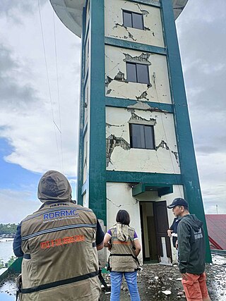
The 1990 Luzon earthquake occurred on July 16 at 4:26 p.m. (PDT) or 3:26 p.m. (PST) on the densely populated island of Luzon in the Philippines. The shock had a surface-wave magnitude of 7.8 and produced a 125 km-long ground rupture that stretched from Dingalan, Aurora to Kayapa, Nueva Vizcaya. The event was a result of strike-slip movements along the Philippine Fault and the Digdig Fault within the Philippine fault system. The earthquake's epicenter was near the town of Rizal, Nueva Ecija, northeast of Cabanatuan. An estimated 1,621 people were killed, most of the fatalities located in Central Luzon and the Cordillera region.

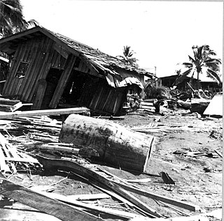
The 1976 Moro Gulf earthquake and tsunami occurred on near the islands of Mindanao and Sulu, in the Philippines. It measured 8.0 on the moment magnitude scale occurring at a depth of 20 km (12 mi). The earthquake was accompanied by a destructive tsunami that resulted in a majority of the estimated 5,000 to 8,000 fatalities. It was the deadliest and strongest earthquake in the Philippines in 58 years since the 1918 Celebes Sea earthquake.
The 2012 Negros earthquake occurred on February 6 at , with a body wave magnitude of 6.7 and a maximum intensity of VII (Destructive) off the coast of Negros Oriental, Philippines. The epicenter of the thrust fault earthquake was approximately 72 kilometres (45 mi) north of Negros Oriental's provincial capital, Dumaguete.

The 2013 Bohol earthquake occurred on October 15 at in Bohol, an island province located in Central Visayas, Philippines. The magnitude of the earthquake was recorded at 7.2, with epicenter 6 kilometres (3.7 mi) S 24° W of Sagbayan, and its depth of focus was 12 kilometres (7.5 mi). It affected the whole Central Visayas region, particularly Bohol and Cebu. The earthquake was felt in the whole Visayas area and as far as Masbate island in the north and Cotabato provinces in southern Mindanao.

The 2017 Batangas earthquakes were an earthquake swarm that occurred from early April to mid-August 2017, affecting the province of Batangas in the Philippines and other nearby areas.
On July 6, 2017, a 6.5 magnitude earthquake hit Leyte, causing at least 4 deaths and 100 injuries. The quake also caused power interruptions in the whole of Eastern Visayas and nearby Bohol.
On April 22, 2019, at 5:11:09 p.m. (PST), an earthquake with a magnitude of 6.1Mw struck the island of Luzon in the Philippines, leaving at least 18 dead, three missing and injuring at least 256 others. Despite the fact that the epicenter was in Zambales, most of the damage to infrastructure occurred in the neighboring province of Pampanga, which suffered damage to 29 buildings and structures.
The 2019 Eastern Samar Earthquake struck the islands of Visayas in the Philippines on April 23, 2019, at 1:37:51 p.m. (PST). It had a moment magnitude of 6.5 and a local magnitude of 6.2 with a max intensity of VI based on the PHIVOLCS earthquake intensity scale (PEIS). The epicenter was in San Julian, Eastern Samar and the hypocenter was at a depth of 64 km(~39.76 mi). As of April 30, 2019 there were 172 aftershocks ranging from magnitudes of 1.6 to 4.6. The earthquake injured 48 people and damaged about 245 homes.

The 2019 Batanes earthquake was a magnitude 6.0 earthquake which struck Batanes, Philippines on July 27, 2019. It was preceded by a 5.4 magnitude foreshock. Nine people were killed by the combined effects of the earthquakes.
The 2019 Cotabato earthquakes were an earthquake swarm which struck the province of Cotabato on the island of Mindanao in the Philippines in October 2019. Three of these earthquakes were above 6.0 on the moment magnitude scale with a Mercalli intensity of VIII. More than 40 people have been reported dead or missing and nearly 800 were injured as a result of these events.
At 14:11 PST on December 15, 2019, the province of Davao del Sur on the island of Mindanao in the Philippines was struck by an earthquake measuring 6.8 . It had a maximum perceived intensity of VII on the Modified Mercalli Intensity Scale. At least 13 people were killed and another 210 injured.

On 18 August 2020, at 8:03 PST, a 6.6 magnitude earthquake struck the island province of Masbate in the Philippines, leaving at least 2 dead and 170 injured.
On 9 July 2019, at 8:36 PM (PST), an earthquake measuring 5.6 jolted the province of North Cotabato, Davao del Sur, and other nearby provinces. The National Disaster Risk Reduction and Management Council reported one dead and three injured in Makilala after the earthquake, and a total of 164 families affected in Cotabato Province. Near the epicenter of the earthquake, the severity of strong ground motion was assigned VI (Strong) on the Modified Mercalli intensity scale. A total of 106 schools, 119 houses, and 14 other infrastructures were damaged by the earthquake.
On February 7, 2021, at 12:22 PM PST, an earthquake measuring Mww 6.0 struck Davao del Sur and Cotabato. The event registered a Modified Mercalli Intensity Scale (MMI) of VIII (Severe) with VII on the PHIVOLCS Earthquake Intensity Scale (PEIS).
On August 12, 2021, at 01:46:12 PST, a strong Mw 7.1 earthquake struck the island of Mindanao at a depth of 55.1 kilometers (34.2 mi). It had a maximum perceived Intensity V on the PHIVOLCS Earthquake Intensity Scale. No damage or injuries were reported but a young man was killed by the earthquake.
The 1879 Surigao earthquake occurred on June 30 at 18:38 02:55 local time on the northeastern tip of Mindanao. The earthquake with a moment magnitude (Mw ) of 7.4 struck with an epicenter just south of Lake Mainit. Extensive damage occurred but there were no reports of casualties.
The 1955 Lanao earthquake struck Lanao del Sur on April 1 at 02:17 local time. The earthquake measuring 7.4 on the moment magnitude scale and assigned a maximum intensity of VIII (Severe) on the Modified Mercalli intensity scale was one of the largest to hit Mindanao. It caused immense damage around the northern and central parts of Mindanao, as well as the southern reaches of Visayas. It killed at least 465 individuals and injured a further 898.

On July 27, 2022, at 8:43:24 a.m. (PHT), an earthquake struck the island of Luzon in the Philippines. The earthquake had a magnitude of 7.0 Mw , with an epicenter in Abra province. Eleven people were reported dead and 615 were injured. At least 35,798 homes, schools and other buildings were damaged or destroyed, resulting in ₱1.88 billion (US$34 million) worth of damage.

On December 2, 2023, at 22:37 PST, a moment magnitude (Mww ) 7.6 earthquake occurred off the island of Mindanao in the Philippines. The shallow subduction earthquake killed at least three people and left 79 injured.


