
The Aegean Sea plate is a small tectonic plate located in the Eastern Mediterranean under Southern Greece and western Turkey. Its southern edge is the Hellenic subduction zone south of Crete, where the African plate is being swept under the Aegean Sea plate. Its northern margin is a divergent boundary with the Eurasian plate.
The 1481 Rhodes earthquake occurred at 3:00 in the morning on 3 May. It triggered a small tsunami, which caused local flooding. There were an estimated 30,000 fatalities. It was the largest of a series of earthquakes that affected Rhodes, starting on 15 March 1481, continuing until January 1482.

The Hellenic Trench (HT) is an oceanic trough located in the forearc of the Hellenic arc, an arcuate archipelago on the southern margin of the Aegean Sea plate, or Aegean Plate, also called Aegea, the basement of the Aegean Sea. The HT begins in the Ionian Sea near the mouth of the Gulf of Corinth and curves to the south, following the margin of the Aegean Sea. It passes close to the south shore of Crete and ends near the island of Rhodes just offshore Anatolia.
The 1303 Crete earthquake occurred at about dawn on 8 August. It had an estimated magnitude of about 8, a maximum intensity of IX (Violent) on the Mercalli intensity scale, and triggered a major tsunami that caused severe damage and loss of life on Crete and at Alexandria. It badly damaged the Lighthouse of Alexandria.
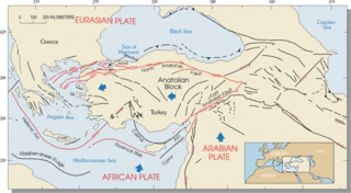
The Hellenic arc or Aegean arc is an arcuate mountain chain of the southern Aegean Sea located on the southern margin of the Aegean Sea plate. Geologically it results from the subduction of the African plate under it along the Hellenic subduction zone. The Hellenic Trench trends parallel to its southern side. The Aegean Sea plate, a microplate, is often considered part of the Eurasian plate from which it is in the process of diverging. The arc itself is mainly marine, the mountaintops appearing as islands in the Ionian Sea, Crete and its environs, or in the Dodecanese group. It encroaches on mainland terrain in the Peloponnesus, on Crete, on Rhodes, and on the southern coast of Anatolia, thus being encompassed by both Greece and Turkey.

The 1881 Chios earthquake occurred at 13:40 local time on 3 April. It caused severe damage on the island of Chios and also affected Çeşme and Alaçatı on the coast of Turkey. The earthquake had an estimated magnitude of 7.3 and there were an estimated 7,866 casualties. The devastation from the earthquake was the last of the three 'catastrophes' that affected the island of Chios in the 19th century.

The 1932 Ierissos earthquake occurred at 19:20 on 26 September. It caused severe damage in Ierissos, Greece and the surrounding part of the Chalkidiki peninsula, with 161–491 casualties reported.

An earthquake occurred in the northern Aegean Sea between Greece and Turkey on May 24, 2014. It had a moment magnitude of 6.9 and a maximum Mercalli intensity of VIII (Severe). Serious damage was reported on the Turkish island of Imbros and the cities of Edirne and Çanakkale, as well as on the Greek island of Lemnos. The earthquake was felt in Bulgaria and southern Romania. Several aftershocks followed the main shock, the strongest measuring 5.3 ML. This aftershock struck the Gulf of Saros at 12:31 local time.
The 1956 Amorgos earthquake occurred at 03:11 UTC on July 9. It had a magnitude of 7.7 on the moment magnitude scale and a maximum perceived intensity of IX on the Mercalli intensity scale. The epicentre was to the south of the island of Amorgos, the easternmost island of the Cyclades in the Aegean Sea. There was significant damage on Amorgos and the neighbouring island of Santorini. It was the largest earthquake in Greece in the 20th century. It was followed 13 minutes later by a magnitude 7.2 earthquake near Santorini. It triggered a major tsunami with a maximum run-up of 30 m. The combined effects of the earthquake shaking and the tsunami caused the deaths of 53 people with a further 100 injured.

On 21 July 2017, a large earthquake measuring 6.6 on the moment magnitude scale struck right near Bodrum, a popular town of tourism in Turkey, killing 2 and injuring hundreds. Mostly referenced as the 2017 Bodrum–Kos earthquake, this earthquake generated a tsunami which was one of the largest tsunamis in the Mediterranean Sea region.
The 1886 Peloponnese earthquake occurred at 23:27 local time on 27 August. It had an estimated magnitude between 6.8 and 7.3 on the moment magnitude scale and a maximum felt intensity of X (Extreme) on the Mercalli intensity scale. It caused extensive damage in Messenia, with the towns of Filiatra and Marathos both severely affected. Between 326 and 600 people were killed. It was felt over a wide area from the Khedivate of Egypt to Malta and possibly as far away as Bern and Marseille.

An earthquake with a moment magnitude of 7.0 occurred on 30 October 2020 about 14 km (8.7 mi) northeast of the Greek island of Samos. Although Samos was closest to the epicentre, it was the large Turkish city İzmir, 70 km (43 mi) northeast that was heavily affected—more than 700 residential and commercial structures were seriously damaged or destroyed. One hundred and seventeen people died in İzmir Province while an additional 1,034 were injured. In Greece, there were two fatalities and 19 injured. The earthquake is the deadliest in the year 2020, and the third major earthquake to strike Turkey that year. It generated an unusually large tsunami. The event is called the Samos earthquake by the International Seismological Centre.
The 1856 Heraklion earthquake, also known as the Crete earthquake or Rhodes earthquake, occurred on the morning of October 12 at 02:45 am local time. This extremely catastrophic earthquake had an estimated magnitude of 7.7 to 8.3 at a depth of approximately 61 to 100 km. The earthquake was felt over a very wide area extending from Sicily, Italy to the Levant and North Africa. On the Greek island of Crete, the effects of the earthquake were cataclysmic, over 500 bodies were recovered in the city of Heraklion. Shockwaves from the earthquake were felt intensely, covering all of the Ottoman Empire; present-day Turkey, Cyprus and the Middle East where damage and human losses were reported. In Malta, the Għajn Ħadid Tower—a coastal watchtower built around the year 1638—was severely damaged in the earthquake, when its upper floor collapsed. In Cairo, Egypt, the earthquake destroyed buildings, created seiches in canals, and killed several people. Off the Egyptian and Italian coasts, sailors reported feeling a seaquake.
The 1986 Kalamata earthquake struck the southern Peloponnese Region of Greece on September 13 at 20:24 local time. The 12.5 km (7.8 mi) deep moment magnitude (Mw ) 5.9 earthquake had an epicenter near the coastal city of Kalamata and was assigned X (Extreme) on the Mercalli intensity scale. The earthquake was the result of normal faulting along a northwest-dipping fault and produced surface ruptures. Extensive damage was reported in Kalamata and Elaiochori. At least 20 people died and 330 were injured. Survivors sought refuge at campsites and reconstruction work lasted five years.
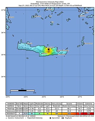
A moment magnitude 6.0 earthquake struck the island of Crete in Greece at a depth of 6 km on 27 September 2021. The epicenter of the earthquake was located southeast of Heraklion. The quake killed one person, injured 36 and damaged over 5,000 old buildings on the island.
The 2021 Lasithi earthquake was a magnitude 6.4 earthquake with a maximum intensity of VIII (Severe) on the Modified Mercalli Intensity Scale which occurred on 12 October 2021, 12:24 (UTC+3:30) off the island of Crete. The quake was also felt at low intensity as far as Cairo and Istanbul.
The 479 BC Potidaea tsunami is the oldest record of a paleotsunami in human history. The tsunami is believed to have been triggered by a 7.0 earthquake in the north Aegean Sea. The associated tsunami may have saved the colony of Potidaea from an invasion by Persians from the Achaemenid Empire.
The 1968 Aegean Sea earthquake was a 7.0 earthquake that occurred in the early morning hours of February 20, 1968 local time about 57.1 km (35.5 mi) away from Myrina, Greece. This earthquake occurred between mainland Greece and Turkey, meaning both countries were impacted. 20 people died, and 39 people were injured to various degrees. It was the deadliest Greek earthquake since the 1956 Amorgos earthquake.
The 1933 Kos earthquake struck the Aegean Sea region on 23 April. It measured Mw 6.4 and had an epicenter offshore, near Kos, Greece. The earthquake collapsed many buildings on Kos, Nisyros and other islands. At least 181 people were killed with a possible death toll reaching several hundred.
