
A tsunami is a series of waves in a water body caused by the displacement of a large volume of water, generally in an ocean or a large lake. Earthquakes, volcanic eruptions and underwater explosions above or below water all have the potential to generate a tsunami. Unlike normal ocean waves, which are generated by wind, or tides, which are in turn generated by the gravitational pull of the Moon and the Sun, a tsunami is generated by the displacement of water from a large event.

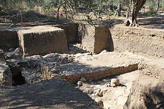
Segesta was one of the major cities of the Elymians, one of the three indigenous peoples of Sicily. The other major cities of the Elymians were Eryx and Entella. It is located in the northwestern part of Sicily in Italy, near the modern commune of Calatafimi-Segesta in the province of Trapani. The hellenization of Segesta happened very early and had a profound effect on its people.

The Battle of Artemisium or Artemision was a series of naval engagements over three days during the second Persian invasion of Greece. The battle took place simultaneously with the land battle at Thermopylae, in August or September 480 BC, off the coast of Euboea and was fought between an alliance of Greek city-states, including Sparta, Athens, Corinth and others, and the Persian Empire of Xerxes I.

The History of the Peloponnesian War is a historical account of the Peloponnesian War, which was fought between the Peloponnesian League and the Delian League. It was written by Thucydides, an Athenian historian who also served as an Athenian general during the war. His account of the conflict is widely considered to be a classic and regarded as one of the earliest scholarly works of history. The History is divided into eight books.
Opus was an ancient Greek city that was the chief city of a tribe of Locri, who were called from this place the Opuntian Locrians, and the territory, the Opuntian Locris.

Potidaea was a colony founded by the Corinthians around 600 BC in the narrowest point of the peninsula of Pallene, the westernmost of three peninsulas at the southern end of Chalcidice in northern Greece.
Cleonae or Cleonæ or Kleonai was an ancient city on the Acte or Akte (Ακτή) peninsula, the easternmost of the three peninsulas forming the ancient Chalcidice, on its western coast, south of Thyssus (Thyssos). Thucydides says that among the cities of the peninsula, Sane was colony of Andros, while Thyssus, Cleonae, Acrothoum, Olophyxus and Dium had a heterogeneous population of bilingual barbarians formed by a few Chalcidians and, the rest, Pelasgians, Bisaltians, Crestonians and Edoni. Strabo points out that its primitive populated was composed of Pelasgians from Lemnos. According to Strabo, it was colonized by Euboean colonists from Chalcis. Heraclides Lembus also writes that Chalcidians settled there. It was a member of the Delian League as it appears on the tribute lists to Athens during the Peloponnesian War.
Antandrus or Antandros was an ancient Greek city on the north side of the Gulf of Adramyttium in the Troad region of Anatolia. Its surrounding territory was known in Greek as Ἀντανδρία (Antandria), and included the towns of Aspaneus on the coast and Astyra to the east. It has been located on Devren hill between the modern village of Avcılar and the town of Altınoluk in the Edremit district of Balıkesir Province, Turkey.
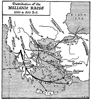
Doris is a small mountainous district in ancient Greece, bounded by Aetolia, southern Thessaly, the Ozolian Locris, and Phocis. It is the original homeland of the Dorian Greeks. It lies between Mounts Oeta and Parnassus, and consists of the valley of the river Pindus (Πίνδος), a tributary of the Cephissus, into which it flows not far from the sources of the latter. The Pindus is now called the Apostoliá. This valley is open towards Phocis; but it lies higher than the valley of the Cephissus, rising above the towns of Drymaea, Tithronium, and Amphicaea, which are the last towns in Phocis.
Heraclea (Herakleia) in Trachis, also called Heraclea Trachinia, was a colony founded by the Spartans in 426 BC, the sixth year of the Peloponnesian War. It was also a polis (city-state).

Opuntian Locris or Eastern Locris was an ancient Greek region inhabited by the eastern division of the Locrians, the so-called tribe of the Locri Epicnemidii or Locri Opuntii.

Atalanti or Atalantonisi (Αταλαντονήσι) or Talandonísi (Ταλαντονήσι) is a small uninhabited island in the North Euboean Gulf, about 600 m off the coast near the town Atalanti, Phthiotis, Greece. There are several small islets next to Atalanti island, including the islet of Agios Nikolaos.

Oreus or Oreos, prior to the 5th century BC called Histiaea or Histiaia (Ἱστίαια), also Hestiaea or Hestiaia (Ἑστίαια), was a town near the north coast of ancient Euboea, situated upon the river Callas, at the foot of Mount Telethrium, and opposite Antron on the Thessalian coast. From this town the whole northern extremity of Euboea was named Histiaeotis According to some it was a colony from the Attic deme of Histiaea; according to others it was founded by the Thessalian Perrhaebi. Another foundation story had it that the name Histiaea is said to derive from the mythical figure Histiaea, the daughter of Hyrieus. It was one of the most ancient of the Euboean cities. It occurs in the Catalogue of Ships in the Iliad, where Homer gives it the epithet of πολυστάφυλος ; and the Periplus of Pseudo-Scylax mentions it as one of the four cities of Euboea. It was an important city in classical antiquity due to its strategic location at the entrance of the North Euboean Gulf, in the middle of a large and fertile plain.

The Erythraean Sea was a former maritime designation that always included the Gulf of Aden, and at times other seas between Arabia Felix and the Horn of Africa. Originally an ancient Greek geographical designation, the term was used throughout Europe until the 18th and 19th centuries. The area referred to by this name frequently extended beyond the Gulf of Aden—as in the famous 1st-century Periplus of the Erythraean Sea—to designate all of the present-day Red Sea, Arabian Sea, Persian Gulf, and Indian Ocean as a single maritime area.
Canae was, in classical antiquity, a city in ancient Aeolis, on the island of Argennusa in the Aegean Sea off the modern Dikili Peninsula on the coast of modern-day Turkey, near the modern village of Bademli. Today Argennusa has joined the mainland as the Kane Promontory off the Dikili Peninsula. Canae is famous as the site of the Battle of Arginusae in 406 B.C.
Daphnus or Daphnous was a city on the Euboean Sea, originally belonging to ancient Phocis, which thus extended from the Corinthian Gulf to the Euboean sea. Its narrow territory separated the Locri Epicnemidii from the Locri Opuntii; but it was afterwards assigned to the Opuntii. The town was in ruins in the time of Strabo, who fixes its site by describing it as distant 20 stadia from Cynus and 120 from Elateia, and as having a harbour. Daphnus appears in an inscription dated to 407 BCE. Daphnus lay at the head of a pass that was one of the major arteries from northern to central Greece.
Orobiae or Orobiai was a town on the western coast of ancient Euboea, between Aedepsus and Aegae, which possessed an oracle of Apollo Selinuntius. The town was partly destroyed by an earthquake and an inundation of the sea in the 426 BC Malian Gulf tsunami. This town seems to be the one mentioned by Stephanus of Byzantium under the name of Orope (Ὀρόπη), who describes it as "a city of Euboea, having a very renowned temple of Apollo."
The 551 Malian Gulf earthquake took place in the Spring of 551 in the vicinity of the Malian Gulf. It affected the cities of Echinus and Tarphe.
The 479 BC Potidaea tsunami is the oldest record of a paleotsunami in human history. The tsunami is believed to have been triggered by a 7.0 earthquake in the north Aegean Sea. The associated tsunami may have saved the colony of Potidaea from an invasion by Persians from the Achaemenid Empire.
