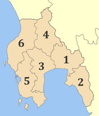
Messenia or Messinia is a regional unit in the southwestern part of the Peloponnese region, in Greece. Until the implementation of the Kallikratis plan on 1 January 2011, Messenia was a prefecture (nomos) covering the same territory. The capital and largest city of Messenia is Kalamata.

The 1693 Sicily earthquake was a natural disaster that struck parts of southern Italy near Sicily, then a territory part of the Crown of Aragon by the Kings of Spain Calabria and Malta, on 11 January at around 21:00 local time. This earthquake was preceded by a damaging foreshock on 9 January. The main quake had an estimated magnitude of 7.4 on the moment magnitude scale, the most powerful in recorded Italian history, and a maximum intensity of XI (Extreme) on the Mercalli intensity scale, destroying at least 70 towns and cities, seriously affecting an area of 5,600 square kilometres (2,200 sq mi) and causing the death of about 60,000 people.

The 1953 Ionian earthquake struck the southern Ionian Islands in Greece on August 12. In mid-August, there were over 113 recorded earthquakes in the region between Kefalonia and Zakynthos, and the most destructive was the August 12 earthquake. The event measured 6.8 on the moment magnitude scale, raised the whole island of Kefalonia by 60 cm (24 in), and caused widespread damage throughout the islands of Kefalonia and Zakynthos. The maximum felt intensity of shaking was X (extreme) on the Mercalli intensity scale. Between 445 and 800 people were killed.
The 1976 Friuli earthquake, also known in Italy as Terremoto del Friuli, occurred on 6 May 1976, at 21:00:13 with a moment magnitude of 6.5 and a maximum EMS intensity of X. The shock occurred in the Friuli region in northeast Italy near the town of Gemona del Friuli. 990 people were killed, up to about 3,000 were injured, and more than 157,000 were left homeless.
The 1202 Syria earthquake struck at about dawn on 20 May 1202 with an epicenter in southwestern Syria. The earthquake is estimated to have killed around 30,000 people. It was felt over an extensive area, from Sicily to Mesopotamia and Anatolia to upper Egypt, mostly affecting the Ayyubid Sultanate and the Kingdom of Jerusalem. The cities of Tyre, Acre and Nablus were heavily damaged. A magnitude of 7.6 has been estimated with damage up to XI on the Mercalli intensity scale.
The 1481 Rhodes earthquake occurred at 3:00 in the morning on 3 May. It triggered a small tsunami, which caused local flooding. There were an estimated 30,000 fatalities. It was the largest of a series of earthquakes that affected Rhodes, starting on 15 March 1481, continuing until January 1482.
The 1303 Crete earthquake occurred at about dawn on 8 August. It had an estimated magnitude of about 8, a maximum intensity of IX (Violent) on the Mercalli intensity scale, and triggered a major tsunami that caused severe damage and loss of life on Crete and at Alexandria. It badly damaged the Lighthouse of Alexandria.
The 1877 Iquique earthquake occurred at 21:16 local time on 9 May. It had a magnitude of 8.5 on the surface-wave magnitude scale. Other estimates of its magnitude have been as high as 8.9 and 9.0 . It had a maximum intensity of XI (Extreme) on the Mercalli intensity scale and triggered a devastating tsunami. A total of 2,385 people died, mainly in Fiji from the tsunami.
The 1901 Black Sea earthquakewas a 7.2 magnitude earthquake, the most powerful earthquake ever recorded in the Black Sea. The earthquake epicenter was located in the east of Cape Kaliakra, 30 kilometres (19 mi) off northeast coast of Bulgaria. The mainshock occurred at a depth of 15 km (9.3 mi) and generated a 4–5-metre (13–16 ft) high tsunami that devastated the coastal areas of Romania and Bulgaria. In Romania, the earthquake was felt not only throughout Northern Dobruja, but also in Oltenia and Muntenia, and even in southern Moldova.
The 1630 Crete earthquake reportedly occurred at around 09:00 on 9 March 1630 in the Kythira Strait, off the coast of Crete. Until the mid-1990s, the earthquake had traditionally been referred to as the 1629 Crete earthquake, which had been documented to have occurred at about 10:00 on Saturday 27 February 1629. Extensive research by several experts on the subject since the late 1980s has revealed that a calculation error mis-dated the occurrence by several days and a year.
The 1856 Jijel earthquakes occurred on August 21 and 22 near the coastal area of northern Algeria around the city of Jijel. The magnitude of the two shocks are unknown, but each had a maximum Mercalli intensity of IX (Violent). Each of these high intensity shocks were felt as far as Genoa in Northern Italy and were followed by a tsunami that affected the Mediterranean Sea. Three people were killed as a result of the second event.
The 2002 Tbilisi earthquake occurred on April 25 in the Caucasus country of Georgia. The United States' National Earthquake Information Center (NEIC) placed the magnitude at 4.3 Ms and 4.8 mb . This moderate magnitude event resulted in a maximum MSK intensity of VII to VIII (Damaging). An independent investigation estimated the total losses at $160 million (US) while the Centre for Research on the Epidemiology of Disasters estimated the total losses at 350 million. Between five and seven were killed, 52–70 were injured, and more than 1,000 were left homeless.
The 1953 Paphos earthquake struck British Cyprus on the morning of 10 September, at 06:05 EET. It had a magnitude of Ms 6.5 on the surface-wave magnitude scale, and had a maximum intensity of X (Extreme) on the Modified Mercalli intensity scale. The epicenter of this earthquake was situated off the island's west coast, near the city of Paphos. At least 40 people died and 100 were injured. It was also felt in Rhodes, Turkey, Egypt, Lebanon and Kastellorizo.
The 1856 Heraklion earthquake, also known as the Crete earthquake or Rhodes earthquake, occurred on the morning of October 12 at 02:45 am local time. This extremely catastrophic earthquake had an estimated magnitude of 7.7 to 8.3 at a depth of approximately 61 to 100 km. The earthquake was felt over a very wide area extending from Sicily, Italy to the Levant and North Africa. On the Greek island of Crete, the effects of the earthquake were cataclysmic, over 500 bodies were recovered in the city of Heraklion. Shockwaves from the earthquake were felt intensely, covering all of the Ottoman Empire; present-day Turkey, Cyprus and the Middle East where damage and human losses were reported. In Malta, the Għajn Ħadid Tower—a coastal watchtower built around the year 1638—was severely damaged in the earthquake, when its upper floor collapsed. In Cairo, Egypt, the earthquake destroyed buildings, created seiches in canals, and killed several people. Off the Egyptian and Italian coasts, sailors reported feeling a seaquake.
The western coast of West Sulawesi was struck by a major earthquake on 23 February 1969 at 00:36 UTC. It had a magnitude of 7.0 and a maximum felt intensity of VIII on the Modified Mercalli intensity scale. It triggered a major tsunami that caused significant damage along the coast of the Makassar Strait. At least 64 people were killed, with possibly a further 600 deaths caused by the tsunami.
The 1986 Kalamata earthquake struck the southern Peloponnese Region of Greece on September 13 at 20:24 local time. The 12.5 km (7.8 mi) deep moment magnitude (Mw ) 5.9 earthquake had an epicenter near the coastal city of Kalamata and was assigned X (Extreme) on the Mercalli intensity scale. The earthquake was the result of normal faulting along a northwest-dipping fault and produced surface ruptures. Extensive damage was reported in Kalamata and Elaiochori. At least 20 people died and 330 were injured. Survivors sought refuge at campsites and reconstruction work lasted five years.
The 1959 Coatzacoalcos earthquake occurred at 02:25 local time on August 26 near the Mexican state of Veracruz. The earthquake measured 6.4 Mw at a depth of 21 km (13 mi), and had a maximum Modified Mercalli intensity of VIII (Severe). It had an epicenter immediately off the coast of Coatzacoalcos. The shallow back-arc thrust faulting earthquake damaged the cities of Acayucan, Coatzacoalcos, Jáltipan and Minatitlán. A total of 25 people died, including 10 from Jáltipan while a further 200 were injured. The Middle America Trench, a subduction zone that borders the southwestern coast of Mexico and Central America, accounts for much of the seismicity in Mexico. The eastern side of the country near the Gulf of Mexico rarely experiences large earthquakes although they have been recorded around the Veracruz area, where seismicity is higher compared to other parts of the gulf. Seismicity in the gulf is attributed to back-arc compression due to subduction.
The 1743 Salento earthquake affected the Apulian region of southwestern Italy on 20 February at 23:30 IST. The ~7.1 Mw earthquake had an epicenter in the Adriatic and Ionian seas, off the coast of modern-day Lecce and Brindisi provinces in Salento. It had a maximum Modified Mercalli intensity of IX (Violent), causing heavy damage in Nardò. Damage was also reported across the sea, in the Balkans. The earthquake also generated a tsunami of up to 11 meters in run-up. Between 180 and 300 people were killed in the disaster.

The 1867 Central Java earthquake occurred on June 10 at between 04:20 and 04:30 local time. It struck off the southern coast of the Indonesian island with an estimated moment magnitude of 7.8 (Mw ). Widespread devastation occurred in Central Java, where as many as 700 people were killed. The intermediate-depth intraslab earthquake did not cause a tsunami.
