The 1938 Banda Sea earthquake occurred on February 2 at 04:04 local time with an estimated magnitude of 8.5-8.6 on the moment magnitude scale. Shaking was intense with an assigned Rossi–Forel intensity of VII and intensity of VI (Strong) on the Modified Mercalli intensity scale. This oblique-slip event generated a destructive tsunami of up to 1.5 metres in the Banda Sea region, but there were no deaths.

The 1999 Athens earthquake occurred on September 7 at near Mount Parnitha in Greece with a moment magnitude of 6.0 and a maximum Mercalli intensity of IX (Violent). The proximity to the Athens metropolitan area resulted in widespread structural damage, mainly to the nearby suburban towns of Ano Liosia, Acharnes, Fyli, Thrakomakedones, Kifissia, Metamorfosi, Kamatero and Nea Filadelfeia. More than 100 buildings across those areas collapsed trapping scores of victims under their rubble while dozens more were severely damaged. With damage estimated at $3–4.2 billion, 143 people were killed, and up to 1,600 were treated for injuries in Greece's deadliest natural disaster in almost half a century.
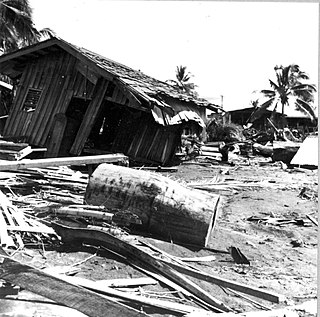
The 1976 Moro Gulf earthquake and tsunami occurred on near the islands of Mindanao and Sulu, in the Philippines. It measured 8.0 on the moment magnitude scale occurring at a depth of 20 km (12 mi). The earthquake was accompanied by a destructive tsunami that resulted in a majority of the estimated 5,000 to 8,000 fatalities. It was the deadliest and strongest earthquake in the Philippines in 58 years since the 1918 Celebes Sea earthquake.
The 1303 Crete earthquake occurred at about dawn on 8 August. It had an estimated magnitude of about 8, a maximum intensity of IX (Violent) on the Mercalli intensity scale, and triggered a major tsunami that caused severe damage and loss of life on Crete and at Alexandria. It badly damaged the Lighthouse of Alexandria.

The 1932 Ierissos earthquake occurred at 19:20 on 26 September. It caused severe damage in Ierissos, Greece and the surrounding part of the Chalkidiki peninsula, with 161–491 casualties reported.
The 1941 Andaman Islands earthquake struck the Andaman Islands on June 26 with a magnitude of 7.7 to 8.1. Details of this event are poorly known as much of Southeast Asia was in the turmoil of World War II. The quake caused severe damage in the Andaman Islands. The tsunami it triggered was reported along the Andaman and Nicobar Islands, India and British Ceylon. There may have been damage and deaths in Bangladesh, Myanmar, and Thailand due to the tsunami.
The 1956 Amorgos earthquake occurred at 03:11 UTC on July 9. It had a magnitude of 7.7 on the moment magnitude scale and a maximum perceived intensity of IX on the Mercalli intensity scale. The epicentre was to the south of the island of Amorgos, the easternmost island of the Cyclades in the Aegean Sea. There was significant damage on Amorgos and the neighbouring island of Santorini. It was the largest earthquake in Greece in the 20th century. It was followed 13 minutes later by a magnitude 7.2 earthquake near Santorini. It triggered a major tsunami with a maximum run-up of 30 m. The combined effects of the earthquake shaking and the tsunami caused the deaths of 53 people with a further 100 injured.
The 1999 Ambrym earthquake occurred on November 27 at with a moment magnitude of 7.4 and a maximum Mercalli intensity of VII. The back arc thrust event occurred within the Vanuatu archipelago, just to the south of the volcanic island of Ambrym. Vanuatu, which was previously known as New Hebrides, is subject to volcanic and earthquake activity because it lies on an active and destructive plate boundary called the New Hebrides Subduction Zone. While the National Geophysical Data Center classified the total damage as moderate, a destructive local tsunami did result in some deaths, with at least five killed and up to 100 injured.
The 2004 Les Saintes earthquake occurred at on November 21, 2004, with a moment magnitude of 6.3 and maximum European macroseismic intensity of VIII. The shock was named for Îles des Saintes "Island of the Saints", a group of small islands to the south of Guadeloupe, which is an overseas department of France. Although it occurred near the Lesser Antilles subduction zone, this was an intraplate, normal fault event. It resulted in one death, 13 injuries, and 40 people being made homeless, but the overall damage was considered moderate. A small, nondestructive tsunami was reported, but run-up and inundation distances were difficult to measure due to a storm that occurred on the day of the event. Unusual effects at a volcanic lake on Dominica were also documented, and an aftershock caused additional damage three months later.

On 21 July 2017, a large earthquake measuring 6.6 on the moment magnitude scale struck right near Bodrum, a popular town of tourism in Turkey, killing 2 and injuring hundreds. Mostly referenced as the 2017 Bodrum–Kos earthquake, this earthquake generated a tsunami which was one of the largest tsunamis in the Mediterranean Sea region.

The 1963 Marj earthquake occurred on February 21 in northern Libya. The earthquake occurred at with a moment magnitude of 5.6 and a maximum Mercalli intensity of VIII (Severe). Financial losses totaled US$5 million, with 290–375 deaths, 375–500 injuries, and 12,000 people being rendered homeless.
The 1883 Çeşme earthquake occurred at 12:30 local time on October 15. This earthquake shook a wide area and was felt in the neighboring islands as well as in modern-day Western Turkey. It had a magnitude of 6.8 on the moment magnitude scale and a maximum felt intensity of IX (Violent) on the Mercalli intensity scale. Many homes in small towns between Çeşme and Urla were destroyed and, according to various sources, 53 to 90 people were killed. This was the biggest earthquake ever experienced by Çeşme in its history. The aftershocks of this quake, like the previous event 2 years before, lasted for a long period, continuing for around 5 more months.

An earthquake with a moment magnitude of 7.0 occurred on 30 October 2020 about 14 km (8.7 mi) northeast of the Greek island of Samos. Although Samos was closest to the epicentre, it was the large Turkish city İzmir, 70 km (43 mi) northeast that was heavily affected—more than 700 residential and commercial structures were seriously damaged or destroyed. One hundred and seventeen people died in İzmir Province while an additional 1,034 were injured. In Greece, there were two fatalities and 19 injured. The earthquake is the deadliest in the year 2020, and the third major earthquake to strike Turkey that year. It generated an unusually large tsunami. The event is called the Samos earthquake by the International Seismological Centre.
The 1856 Heraklion earthquake, also known as the Crete earthquake or Rhodes earthquake, occurred on the morning of October 12 at 02:45 am local time. This extremely catastrophic earthquake had an estimated magnitude of 7.7 to 8.3 at a depth of approximately 61 to 100 km. The earthquake was felt over a very wide area extending from Sicily, Italy to the Levant and North Africa. On the Greek island of Crete, the effects of the earthquake were cataclysmic, over 500 bodies were recovered in the city of Heraklion. Shockwaves from the earthquake were felt intensely, covering all of the Ottoman Empire; present-day Turkey, Cyprus and the Middle East where damage and human losses were reported. In Malta, the Għajn Ħadid Tower—a coastal watchtower built around the year 1638—was severely damaged in the earthquake, when its upper floor collapsed. In Cairo, Egypt, the earthquake destroyed buildings, created seiches in canals, and killed several people. Off the Egyptian and Italian coasts, sailors reported feeling a seaquake.
The 2021 Lasithi earthquake was a magnitude 6.4 earthquake with a maximum intensity of VIII (Severe) on the Modified Mercalli Intensity Scale which occurred on 12 October 2021, 12:24 (UTC+3:30) off the island of Crete. The quake was also felt at low intensity as far as Cairo and Istanbul.
The 479 BC Potidaea tsunami is the oldest record of a paleotsunami in human history. The tsunami is believed to have been triggered by a 7.0 earthquake in the north Aegean Sea. The associated tsunami may have saved the colony of Potidaea from an invasion by Persians from the Achaemenid Empire.
On December 5, 1456, the largest earthquake to occur on the Italian Peninsula in historical times struck the Kingdom of Naples. The earthquake had an estimated moment magnitude of Mw 7.19–7.4, and was centred near the town of Pontelandolfo in the present-day Province of Benevento, southern Italy. Earning a level of XI (Extreme) on the Modified Mercalli intensity scale, the earthquake caused widespread destruction in central and southern Italy. Estimates of the death toll range greatly with up to 70,000 deaths reported. It was followed by two strong Mw 7.0 and 6.0 earthquakes to the north on December 30. The earthquake sequence is considered the largest in Italian history, and one of the most studied.
The 1997 Bojnurd earthquake occurred on 4 February at 14:07 IRST in Iran. The epicenter of the 6.5 earthquake was in the Kopet Dag mountains of North Khorasan, near the Iran–Turkmenistan border, about 579 km (360 mi) northeast of Tehran. The earthquake is characterized by shallow strike-slip faulting in a zone of active faults. Seismic activity is present as the Kopet Dag is actively accommodating tectonics through faulting. The earthquake left 88 dead, 1,948 injured, and affected 173 villages, including four which were destroyed. Damage also occurred in Shirvan and Bojnord counties. The total cost of damage was estimated to be over US$ 30 million.
The 1979 Saint Elias earthquake affected Alaska at 12:27 AKST on 28 February. The thrust-faulting 7.5 earthquake had an epicenter in the Granite Mountains. Though the maximum recorded Modified Mercalli intensity was VII, damage was minimal and there were no casualties due to the remoteness of the faulting. Damage also extended across the border in parts of Yukon, Canada.

The 1940 Shakotan earthquake occurred on August 2 at 00:08:22 JST with a moment magnitude (Mw ) of 7.5 and maximum JMA seismic intensity of Shindo 4. The shock had an epicenter off the coast of Hokkaido, Japan. Damage from the shock was comparatively light, but the accomanying tsunami was destructive. The tsunami caused 10 deaths and 24 injuries on Hokkaido, and destroyed homes and boats across the Sea of Japan. The highest tsunami waves were recorded at the coast of Russia while along the coast of Hokkaido, waves were about 2 m.

