
The 1693 Sicily earthquake was a natural disaster that struck parts of southern Italy near Sicily, then a territory part of the Crown of Aragon by the Kings of Spain Calabria and Malta, on 11 January at around 21:00 local time. This earthquake was preceded by a damaging foreshock on 9 January. The main quake had an estimated magnitude of 7.4 on the moment magnitude scale, the most powerful in recorded Italian history, and a maximum intensity of XI (Extreme) on the Mercalli intensity scale, destroying at least 70 towns and cities, seriously affecting an area of 5,600 square kilometres (2,200 sq mi) and causing the death of about 60,000 people.
The Dasht-e Bayaz and Ferdows earthquakes occurred in Dashte Bayaz, Kakhk and Ferdows, Iran in late August and early September 1968. The mainshock measured 7.1 on the moment magnitude scale and had a maximum perceived intensity of X (Extreme) on the Mercalli intensity scale. Damage was heavy in the affected areas with thousands of lives lost in the first event and many hundreds more in the second strong event.
The 1976 Moro Gulf earthquake and tsunami occurred on near the islands of Mindanao and Sulu, in the Philippines. It measured 8.0 on the moment magnitude scale occurring at a depth of 20 km (12 mi). The earthquake was accompanied by a destructive tsunami that resulted in a majority of the estimated 5,000 to 8,000 fatalities. It was the deadliest and strongest earthquake in the Philippines in 58 years since the 1918 Celebes Sea earthquake.
The 1202 Syria earthquake struck at about dawn on 20 May 1202 with an epicenter in southwestern Syria. The earthquake is estimated to have killed around 30,000 people. It was felt over an extensive area, from Sicily to Mesopotamia and Anatolia to upper Egypt, mostly affecting the Ayyubid Sultanate and the Kingdom of Jerusalem. The cities of Tyre, Acre and Nablus were heavily damaged. A magnitude of 7.6 has been estimated with damage up to XI on the Mercalli intensity scale.
Striking southern Italy on 8 September, the 1905 Calabria earthquake had a moment magnitude of 7.2 and a maximum Mercalli intensity of XI (Extreme). The first major earthquake of the 20th century, it severely damaged parts of Lipari, Messina Province and a large area between Cosenza and Nicotera and killed between 557 and 2,500 people.
The 1912 Mürefte earthquake occurred at 03:29 local time on 9 August. It had an estimated magnitude of 7.4 and a maximum intensity of X (Extreme) on the Modified Mercalli intensity scale, causing from 216 to 3,000 casualties.
An earthquake occurred in Antioch on 13 December 115 AD. It had an estimated magnitude of 7.5 on the surface-wave magnitude scale and an estimated maximum intensity of XI (Extreme) on the Mercalli intensity scale. Antioch and surrounding areas were devastated with a great loss of life and property. It triggered a local tsunami that badly damaged the harbour at Caesarea Maritima. The Roman emperor Trajan was caught in the earthquake, as was his successor Hadrian. Although the consul Marcus Pedo Vergilianus was killed, they escaped with only slight injuries and later began a program to rebuild the city.
The 1901 Black Sea earthquakewas a 7.2 magnitude earthquake, the most powerful earthquake ever recorded in the Black Sea. The earthquake epicenter was located in the east of Cape Kaliakra, 30 kilometres (19 mi) off northeast coast of Bulgaria. The mainshock occurred at a depth of 15 km (9.3 mi) and generated a 4–5-metre (13–16 ft) high tsunami that devastated the coastal areas of Romania and Bulgaria. In Romania, the earthquake was felt not only throughout Northern Dobruja, but also in Oltenia and Muntenia, and even in southern Moldova.
Two major earthquakes occurred in the Near East on 18 March and 29 May, AD 1068. The two earthquakes are often amalgamated by contemporary sources. The first earthquake had its epicentre somewhere in the northwestern part of the Arabian Peninsula around Tabuk, while the second was most damaging in the city of Ramla in Palestine, some 500 km to the northwest.
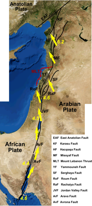
One of the largest earthquakes to hit Syria occurred early in the morning of 29 June 1170. It formed part of a sequence of large earthquakes that propagated southwards along the Dead Sea Transform, starting with the 1138 Aleppo earthquake, continuing with the 1157 Hama, 1170 and 1202 Syria events. The estimated magnitude is 7.7 on the moment magnitude scale, with the maximum intensity of X (Extreme) on the Mercalli intensity scale.
The 1872 Amik (Antakya) earthquake occurred on April 3 with an epicenter within the Amik Valley in the Ottoman Empire. Earthquake had an estimated magnitude of Mw 7.0–7.2 or Ms 7.2 and maximum MSK 64 rating of XI (Catastrophic). Turkey and Syria were devastated by this earthquake, and the region lost at least 1,800 residents.
The 1895 Charleston earthquake, also known as the Halloween earthquake, occurred on October 31, at 05:07 CST near Charleston, Missouri. It had an estimated moment magnitude of 5.8–6.6 and evaluated Modified Mercalli intensity of VIII (Severe). The earthquake caused substantial property damage in the states of Missouri, Illinois, Ohio, Alabama, Iowa, Kentucky, Indiana, and Tennessee. Shaking was widespread, being felt across 23 states and even in Canada. At least two people died and seven were injured.
The 1977 Bob–Tangol earthquake struck Kerman province of Iran on December 20, 1977, at 03:04 Iran Standard Time. The earthquake measured 5.9 and struck at a depth of 22.7 km (14.1 mi). A maximum Modified Mercalli intensity of VII was evaluated based on damage. It had a strike-slip focal mechanism, which was unusual as the source structure was a thrust fault. It was part of a sequence of strong earthquakes along the 400 km (250 mi) Kuh Banan Fault. Between 584 and 665 people perished while a further 500–1,000 were injured; thousands were also made homeless. Casualties from the earthquake was considered moderate due to the sparsely populated area it affected. Preceded by foreshocks the month before, many residents became wary of a larger earthquake and took refuge outside their homes, contributing to the moderate death toll. However, there were none immediately before the mainshock so many were still in their homes when it struck. Aftershocks were felt for several months, some causing additional damage.
The Marash earthquake occurred in the area of Marash during the early morning hours of November 29, 1114. It had an estimated surface-wave magnitude between 7.4 and 7.7 and an epicenter location in modern-day Turkey. The mainshock was preceded by two destructive foreshocks in August and November that same year. At least 40,000 people were killed in the earthquake; a number contested by historians due to the small population in the area at the time. These earthquakes were associated with seismic activity on the East Anatolian Fault.
The 1957 Farsinaj earthquake struck Hamadan province, Iran on 13 December at 05:15 local time. The moment magnitude 6.5 earthquake struck at a depth of 15 km (9.3 mi). The epicenter of the earthquake was located in the seismically active Zagros Mountains. The mountain range was also the location for several historic earthquakes. The earthquake occurred near two segments of the active strike-slip Main Recent Fault. At least 1,130 people died, including over 700 in the village of Farsinaj. Additional deaths also occurred in Dehasiyab, Sarab, and other villages. The earthquake left an estimated 15,000 homeless; poor weather conditions including a winter storm on 21 December killed another 20 people. Several deadly and damaging aftershocks in that month killed a total of 38 people.
The 1893 Malatya earthquake occurred at 02:30 local time on 3 March in Malatya, Eastern Anatolia Region of Turkey. It had a surface wave magnitude of 7.1 and maximum felt intensity of X (Extreme) on the Mercalli intensity scale. This destructive earthquake caused 885 deaths and 164 injuries.
A destructive earthquake affected present-day northwestern Syria and south-central Turkey in January 1344. Estimates of the seismic magnitude (Mw ) range between 6.8 and 7.6. The MSK 64 intensity was VII–VIII at Manbij; VI–VII at Aleppo and IV at Damascus. Thousands died in Syria and many structures were destroyed.
The 1958 Firuzabad earthquake affected Hamadan province, Iran, on 16 August at 22:43 local time. The 6.7 earthquake occurred at a depth of 15 km (9.3 mi), nine months after another severe earthquake struck the same area. It caused severe damage to over 170 villages in the province. Because of several strong foreshocks, most of the population had fled their homes: the death toll thus only reached 132, with 948 injured. A destructive aftershock on 21 September killed another 16 people.
