The Modified Mercalli intensity scale measures the effects of an earthquake at a given location. This is in contrast with the seismic magnitude usually reported for an earthquake.

The epicenter, epicentre, or epicentrum in seismology is the point on the Earth's surface directly above a hypocenter or focus, the point where an earthquake or an underground explosion originates.
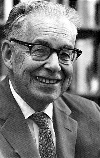
Charles Francis Richter was an American seismologist and physicist. He is the namesake and one of the creators of the Richter scale, which, until the development of the moment magnitude scale in 1979, was widely used to quantify the size of earthquakes. Inspired by Kiyoo Wadati's 1928 paper on shallow and deep earthquakes, Richter first used the scale in 1935 after developing it in collaboration with Beno Gutenberg; both worked at the California Institute of Technology.
The moment magnitude scale is a measure of an earthquake's magnitude based on its seismic moment. Mw was defined in a 1979 paper by Thomas C. Hanks and Hiroo Kanamori. Similar to the local magnitude/Richter scale (ML ) defined by Charles Francis Richter in 1935, it uses a logarithmic scale; small earthquakes have approximately the same magnitudes on both scales. Despite the difference, news media often use the term "Richter scale" when referring to the moment magnitude scale.
Peak ground acceleration (PGA) is equal to the maximum ground acceleration that occurred during earthquake shaking at a location. PGA is equal to the amplitude of the largest absolute acceleration recorded on an accelerogram at a site during a particular earthquake. Earthquake shaking generally occurs in all three directions. Therefore, PGA is often split into the horizontal and vertical components. Horizontal PGAs are generally larger than those in the vertical direction but this is not always true, especially close to large earthquakes. PGA is an important parameter for earthquake engineering, The design basis earthquake ground motion (DBEGM) is often defined in terms of PGA.
The Medvedev–Sponheuer–Karnik scale, also known as the MSK or MSK-64, is a macroseismic intensity scale used to evaluate the severity of ground shaking on the basis of observed effects in an area where an earthquake transpires.
Seismic magnitude scales are used to describe the overall strength or "size" of an earthquake. These are distinguished from seismic intensity scales that categorize the intensity or severity of ground shaking (quaking) caused by an earthquake at a given location. Magnitudes are usually determined from measurements of an earthquake's seismic waves as recorded on a seismogram. Magnitude scales vary based on what aspect of the seismic waves are measured and how they are measured. Different magnitude scales are necessary because of differences in earthquakes, the information available, and the purposes for which the magnitudes are used.
The Richter scale, also called the Richter magnitude scale, Richter's magnitude scale, and the Gutenberg–Richter scale, is a measure of the strength of earthquakes, developed by Charles Richter in collaboration with Beno Gutenberg, and presented in Richter's landmark 1935 paper, where he called it the "magnitude scale". This was later revised and renamed the local magnitude scale, denoted as ML or ML .

The Galilee earthquake of 1837, often called the Safed earthquake, shook the Galilee on January 1 and is one of a number of moderate to large events that have occurred along the Dead Sea Transform fault system that marks the boundary of two tectonic plates; the African plate on the west and the Arabian plate on the east. Intensity assessments for the event were VIII (Damaging) on the Medvedev–Sponheuer–Karnik scale and VIII on the European Macroseismic Scale.

In seismology, an isoseismal map is used to show countour lines of equally felt seismic intensity, generally measured on the Modified Mercalli scale. Such maps help to identify earthquake epicenters, particularly where no instrumental records exist, such as for historical earthquakes. They also contain important information on ground conditions at particular locations, the underlying geology, radiation pattern of the seismic waves, and the response of different types of buildings. They form an important part of the macroseismic approach, i.e. that part of seismology dealing with noninstrumental data. The shape and size of the isoseismal regions can be used to help determine the magnitude, focal depth, and focal mechanism of an earthquake.
The 1995 Gulf of Aqaba earthquake occurred on November 22 at 06:15 local time and registered 7.3 on the Mw scale. The epicenter was located in the central segment of the Gulf of Aqaba, the narrow body of water that separates Egypt's Sinai Peninsula from the western border of Saudi Arabia. At least 8 people were killed and 30 were injured in the meizoseismal area.
Recent advances are improving the speed and accuracy of loss estimates immediately after earthquakes so that injured people may be rescued more efficiently. "Casualties" are defined as fatalities and injured people, which are due to damage to occupied buildings. After major and large earthquakes, rescue agencies and civil defense managers rapidly need quantitative estimates of the extent of the potential disaster, at a time when information from the affected area may not yet have reached the outside world. For the injured below the rubble every minute counts. To rapidly provide estimates of the extent of an earthquake disaster is much less of a problem in industrialized than in developing countries. This article focuses on how one can estimate earthquake losses in developing countries in real time.
Harry Oscar Wood (1879–1958) was an American seismologist who made several significant contributions in the field of seismology in the early twentieth-century. Following the 1906 earthquake in San Francisco, California, Wood expanded his background of geology and mineralogy and his career took a change of direction into the field of seismology. In the 1920s he co-developed the torsion seismometer, a device tuned to detect short-period seismic waves that are associated with local earthquakes. In 1931 Wood, along with another seismologist, redeveloped and updated the Mercalli intensity scale, a seismic intensity scale that is still in use as a primary means of rating an earthquake's effects.
Seismic intensity scales categorize the intensity or severity of ground shaking (quaking) at a given location, such as resulting from an earthquake. They are distinguished from seismic magnitude scales, which measure the magnitude or overall strength of an earthquake, which may, or perhaps may not, cause perceptible shaking.
The 1912 Maymyo earthquake or Burma earthquake struck Burma on the morning of May 23, with an epicentre near Taunggyi and Pyin Oo Lwin in Shan State. The earthquake was initially calculated at 8.0 on the surface-wave magnitude scale (Ms ) by Beno Gutenberg and Charles Francis Richter, and described by them as being one of the most remarkable seismic events in the early 1900s. Recent re-evaluation of the earthquake, however, have revised the magnitude to 7.6–7.9. It was preceded by two foreshocks on May 18 and 21 with respective intensities V and VII on the Rossi–Forel scale, while the mainshock was assigned IX. Shaking was felt throughout most of Burma, parts of Siam and Yunnan; an area covering approximately 375,000 square miles. It was one of the largest earthquakes in the country.
An earthquake occurred at 2:13 p.m. on Friday, July 19, 2019, and affected many people in the middle of the day. Several seismological institutes determined a magnitude of about 5.3 and the epicentral region appeared to be south of Mt Parnitha, ~20 km NW of the Athens metropolitan area. Nearly 20 years before, on the 7th September 1999, Athens was struck by a 6.0 magnitude earthquake.
The 1790 Oran earthquake occurred on 10 October, striking near the coastal city of Oran in Algeria. The earthquake had an evaluated maximum seismic intensity of VIII–X on the European macroseismic scale (EMS-98). An estimated 3,000 people died during the earthquake and accompanying tsunami. The magnitude of this earthquake has been disputed among members of the paleoseismology field, with estimates ranging from 7.5 to even as small as 5.5.
The 1716 Algiers earthquake was part of a seismic sequence which began in February and ended in May 1716. The largest and most destructive shock occurred on February 3 with an estimated moment magnitude of 7.0. The earthquakes with an epicenter thought to be in the Algiers region had a maximum European macroseismic scale (EMS-98) intensity of IX (Destructive), killing approximately 20,000 people. The earthquake was felt in Catania and Syracuse on the Italian island Sicily.
The 1895 Charleston earthquake, also known as the Halloween earthquake, occurred on October 31, at 05:07 CST near Charleston, Missouri. It had an estimated moment magnitude of 5.8–6.6 and evaluated Modified Mercalli intensity of VIII (Severe). The earthquake caused substantial property damage in the states of Missouri, Illinois, Ohio, Alabama, Iowa, Kentucky, Indiana, and Tennessee. Shaking was widespread, being felt across 23 states and even in Canada. At least two people died and seven were injured.