
The Jordan Rift Valley, also Jordan Valley(Hebrew: בִּקְעָת הַיַרְדֵּן Bīqʿāt haYardēn, Arabic: الغور Al-Ghor or Al-Ghawr), is an elongated endorheic basin located in modern-day Israel, Jordan and the West Bank, Palestine. This geographic region includes the entire length of the Jordan River – from its sources, through the Hula Valley, the Korazim block, the Sea of Galilee, the (Lower) Jordan Valley, all the way to the Dead Sea, the lowest land elevation on Earth – and then continues through the Arabah depression, the Gulf of Aqaba whose shorelines it incorporates, until finally reaching the Red Sea proper at the Straits of Tiran.
The 1138 Aleppo earthquake was among the deadliest earthquakes in history. Its name was taken from the city of Aleppo, in northern Syria, where the most casualties were sustained. The earthquake also caused damage and chaos to many other places in the area around Aleppo. The quake occurred on 11 October 1138 and was preceded by a smaller quake on the 10th. It is frequently listed as the third deadliest earthquake in history, following on from the Shensi and Tangshan earthquakes in China. However, the figure of 230,000 deaths reported by Ibn Taghribirdi in the fifteenth century is most likely based on a historical conflation of this earthquake with earthquakes in November 1137 on the Jazira plain and the large seismic event of 30 September 1139 in the Transcaucasian city of Ganja.
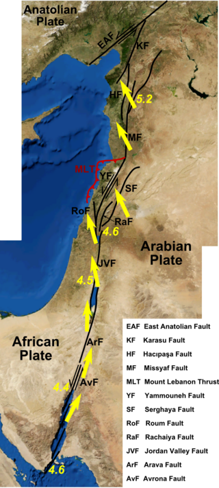
The Dead Sea Transform (DST) fault system, also sometimes referred to as the Dead Sea Rift, is a series of faults that run for about 1,000 km from the Maraş triple junction to the northern end of the Red Sea Rift. The fault system forms the transform boundary between the African plate to the west and the Arabian plate to the east. It is a zone of left lateral (sinistral) displacement, signifying the relative motions of the two plates. Both plates are moving in a general north-northeast direction, but the Arabian plate is moving faster, resulting in the observed left lateral motions along the fault of approximately 107 km at its southern end. A component of extension is also present in the southern part of the transform, which has contributed to a series of depressions, or pull-apart basins, forming the Gulf of Aqaba, Dead Sea, Sea of Galilee, and Hula basins. A component of shortening affects the Lebanon restraining bend, leading to uplift on both sides of the Beqaa valley. There is local transtension in the northernmost part of the fault system, forming the Ghab pull-apart basin. The southern part of the fault system runs roughly along the political border of Lebanon and Israel on its western side, and southern Syria and Jordan on the eastern side.
The 1202 Syria earthquake struck at about dawn on 20 May 1202 with an epicenter in southwestern Syria. The earthquake is estimated to have killed around 30,000 people. It was felt over an extensive area, from Sicily to Mesopotamia and Anatolia to upper Egypt, mostly affecting the Ayyubid Sultanate and the Kingdom of Jerusalem. The cities of Tyre, Acre and Nablus were heavily damaged. A magnitude of 7.6 has been estimated with damage up to XI on the Mercalli intensity scale.

The Galilee earthquake of 1837, often called the Safed earthquake, shook the Galilee on January 1 and is one of a number of moderate to large events that have occurred along the Dead Sea Transform fault system that marks the boundary of two tectonic plates; the African plate on the west and the Arabian plate on the east. Intensity assessments for the event were VIII (Damaging) on the Medvedev–Sponheuer–Karnik scale and VIII on the European Macroseismic Scale.
The 1759 Near East earthquakes shook a large portion of the Levant in October and November of that year. This geographical crossroads in the Eastern Mediterranean were at the time under the rule of the Ottoman Empire. The ruins of Baalbek, a settlement in the Beqaa Valley of Lebanon east of the Litani River, were badly damaged. These 1759 events, along with the earlier 1202 Syria earthquake, are likely the strongest historical earthquakes in the region.
The Galilee earthquake of 363 was a pair of severe earthquakes that shook the Galilee and nearby regions on May 18 and 19. The maximum perceived intensity for the events was estimated to be X on the European macroseismic scale. The earthquakes occurred on the portion of the Dead Sea Transform (DST) fault system between the Dead Sea and the Gulf of Aqaba.

A devastating earthquake known in scientific literature as the Earthquake of 749 struck on January 18, 749, in areas of the Umayyad Caliphate, with the epicenter in Galilee. The most severely affected areas were west and east of the Jordan River. The cities of Tiberias, Beit She'an, Pella, Gadara, and Hippos were largely destroyed, while many other cities across the Levant were heavily damaged. The casualties numbered in the tens of thousands.
The 1995 Gulf of Aqaba earthquake occurred on November 22 at 06:15 local time and registered 7.3 on the scale. The epicenter was located in the central segment of the Gulf of Aqaba, the narrow body of water that separates Egypt's Sinai Peninsula from the western border of Saudi Arabia. At least 8 people were killed and 30 were injured in the meizoseismal area.

The 551 Beirut earthquake occurred on 9 July with an estimated magnitude of about 7.5 on the moment magnitude scale and a maximum felt intensity of X (Extreme) on the Mercalli intensity scale. It triggered a devastating tsunami which affected the coastal towns of Byzantine Phoenicia, causing great destruction and sinking many ships. Overall large numbers of people were reported killed, with one estimate of 30,000 by the anonymous pilgrim of Piacenza for Berytus alone.
An earthquake occurred in Antioch on 13 December 115 AD. It had an estimated magnitude of 7.5 on the surface-wave magnitude scale and an estimated maximum intensity of XI (Extreme) on the Mercalli intensity scale. Antioch and surrounding areas were devastated with a great loss of life and property. It triggered a local tsunami that badly damaged the harbour at Caesarea Maritima. The Roman emperor Trajan was caught in the earthquake, as was his successor Hadrian. Although the consul Marcus Pedo Vergilianus was killed, they escaped with only slight injuries and later began a program to rebuild the city.
The 1956 Chim earthquake was a destructive multiple-shock event that occurred on March 16 in Lebanon along a strand of the Dead Sea Transform (DST) fault system. The epicenter was located in the south of Lebanon in the Chouf District. Six thousand homes were destroyed and another 17,000 were damaged. The number of persons killed was 136.
Two major earthquakes occurred in the Near East on 18 March and 29 May, AD 1068. The two earthquakes are often amalgamated by contemporary sources. The first earthquake had its epicentre somewhere in the northwestern part of the Arabian Peninsula around Tabuk, while the second was most damaging in the city of Ramla in Palestine, some 500 km to the northwest.
The 1170 Syria earthquake was one of the largest earthquakes to hit Syria. It occurred early in the morning of 29 June 1170. It formed part of a sequence of large earthquakes that propagated southwards along the Dead Sea Transform, starting with the 1138 Aleppo earthquake, continuing with the 1157 Hama, 1170 and 1202 Syria events. The estimated magnitude is 7.7 on the moment magnitude scale, with the maximum intensity of X (Extreme) on the Mercalli intensity scale.
The 92 BC Levant earthquake is mentioned in catalogues of historical earthquakes. An earthquake and a tsunami reportedly affected areas of the Levant, including the modern states of Cyprus, Egypt, Israel, and Syria.
The northern part of the Ottoman Empire was struck by a major earthquake on 13 August 1822. It had an estimated magnitude of 7.0 and a maximum felt intensity of IX (Destructive) on the European macroseismic scale (EMS). It may have triggered a tsunami, affecting nearby coasts. Damaging aftershocks continued for more than two years, with the most destructive being on 5 September 1822. The earthquake was felt over a large area including Rhodes, Cyprus and Gaza. The total death toll reported for this whole earthquake sequence ranges between 30,000 and 60,000, although 20,000 is regarded as a more likely number.
The 1872 Amik (Antakya) earthquake occurred on April 3 with an epicenter within the Amik Valley in the Ottoman Empire. Earthquake had an estimated magnitude of Mw 7.0–7.2 or Ms 7.2 and maximum MSK 64 rating of XI (Catastrophic). Turkey and Syria were devastated by this earthquake, and the region lost at least 1,800 residents.
An earthquake struck the Jordan Rift Valley on December 5, AD 1033 and caused extreme devastation in the Levant region. It was part of a sequence of four strong earthquakes in the region between 1033 and 1035. Scholars have estimated the moment magnitude to be greater than 7.0 Mw and evaluated the Modified Mercalli intensity to X (Extreme). It triggered a tsunami along the Mediterranean coast, causing damage and fatalities. At least 70,000 people were killed in the disaster.
The Marash earthquake occurred in the area of Marash during the early morning hours of November 29, 1114. It had an estimated surface-wave magnitude between 7.4 and 7.7 and an epicenter location in modern-day Turkey. The mainshock was preceded by two destructive foreshocks in August and November that same year. At least 40,000 people were killed in the earthquake; a number contested by historians due to the small population in the area at the time. These earthquakes were associated with seismic activity on the East Anatolian Fault.

