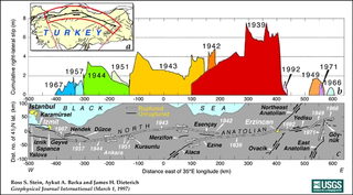
The North Anatolian Fault is an active right-lateral strike-slip fault in northern Anatolia, and is the transform boundary between the Eurasian plate and the Anatolian sub-plate. The fault extends westward from a junction with the East Anatolian Fault at the Karliova triple junction in eastern Turkey, across northern Turkey and into the Aegean Sea for a length of 1200−1500 kilometers. It runs about 20 km south of Istanbul. The North Anatolian Fault is similar in many ways to the San Andreas Fault in California. Both are continental transforms with similar lengths and slip rates. The Sea of Marmara near Istanbul is an extensional basin similar to the Salton Trough in California, where a releasing bend in the strike slip system creates a pull-apart basin.

Şarköy is a municipality and district of Tekirdağ Province, Turkey. Its area is 487 km2, and its population is 33,466 (2022). It is a seaside town on the north coast of the Marmara Sea in East Thrace. Şarköy is 86 km west of the town of Tekirdağ, and can be reached either by the inland road or by the winding coast road, which goes on to Gallipoli. The mayor is Alpay Var (CHP).
An earthquake struck Turkey's eastern Erzincan Province at with a moment magnitude (Mw ) of 7.8 and maximum Mercalli intensity of XII (Extreme). It is tied with the 2023 Turkey–Syria earthquakes as the most-powerful earthquake in Turkey to be recorded by instruments. However, smaller than estimates of the 1668 North Anatolia earthquake. This was one of the largest in a sequence of violent shocks to affect Turkey along the North Anatolian Fault between 1939 and 1999. Surface rupturing, with a horizontal displacement of up to 3.7 meters, occurred in a 360 km long segment of the North Anatolian Fault Zone. The earthquake was the most severe natural loss of life in Turkey in the 20th century, with 32,968 dead, and some 100,000 injured.

The 1999 İzmit earthquake had a moment magnitude of 7.6 and struck Kocaeli Province, Turkey on 17 August. Between 17,127 and 18,373 people died as a result, and the damage was estimated at US$6.5 billion. It was named for the epicenter's proximity to the northwestern city of İzmit. The earthquake occurred at 03:01 local time at a shallow depth of 15 km (9.3 mi). A maximum Mercalli intensity of X (Extreme) was observed. The earthquake lasted for 37 seconds, causing seismic damage, and is widely remembered as one of the deadliest natural disasters in modern Turkish history.
The 1509 Constantinople earthquake or historically Kıyamet-i Sugra occurred in the Sea of Marmara on 10 September 1509 at about 22:00. The earthquake had an estimated magnitude of 7.2 ± 0.3 on the surface-wave magnitude scale. A tsunami and 45 days of aftershocks followed the earthquake. The death toll of this earthquake is poorly known; estimates range between 1,000 and 13,000.
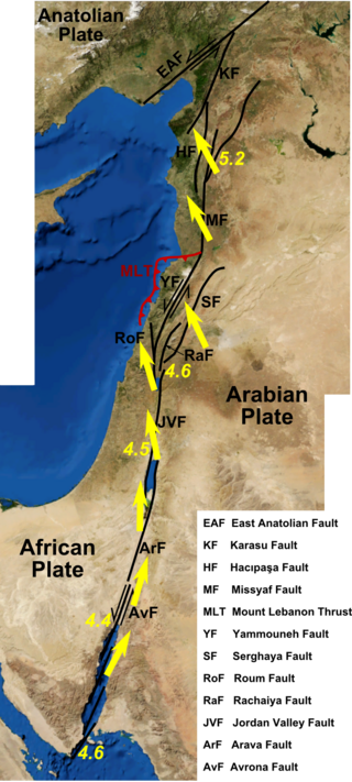
The Dead Sea Transform (DST) fault system, also sometimes referred to as the Dead Sea Rift, is a series of faults that run for about 1,000 km from the Marash triple junction to the northern end of the Red Sea Rift. The fault system forms the transform boundary between the African plate to the west and the Arabian plate to the east. It is a zone of left lateral (sinistral) displacement, signifying the relative motions of the two plates. Both plates are moving in a general north-northeast direction, but the Arabian plate is moving faster, resulting in the observed left lateral motions along the fault of approximately 107 km at its southern end. A component of extension is also present in the southern part of the transform, which has contributed to a series of depressions, or pull-apart basins, forming the Gulf of Aqaba, Dead Sea, Sea of Galilee, and Hula basins. A component of shortening affects the Lebanon restraining bend, leading to uplift on both sides of the Beqaa valley. There is local transtension in the northernmost part of the fault system, forming the Ghab pull-apart basin. The southern part of the fault system runs roughly along the political border of Lebanon and Israel on its western side, and southern Syria and Jordan on the eastern side.

The East Anatolian Fault is a ~700 km long major strike-slip fault zone running from eastern to south-central Turkey. It forms the transform type tectonic boundary between the Anatolian sub-plate and the northward-moving Arabian plate. The difference in the relative motions of the two plates is manifest in the left lateral motion along the fault. The East and North Anatolian faults together accommodate the westward motion of the Anatolian sub-plate as it is squeezed out by the ongoing collision between the Arabian plate and the Eurasian plate.
In seismology, a supershear earthquake is when the propagation of the rupture along the fault surface occurs at speeds in excess of the seismic shear wave velocity. This causes an effect analogous to a sonic boom.
The 1912 Mürefte earthquake occurred at 03:29 local time on 9 August. It had an estimated magnitude of 7.4 and a maximum intensity of X (Extreme) on the Modified Mercalli intensity scale, causing from 216 to 3,000 casualties.

The Sagaing Fault is a major fault in Myanmar, a mainly continental right-lateral transform fault between the Indian plate and Sunda plate. It links the divergent boundary in the Andaman Sea with the zone of active continental collision along the Himalayan front. It passes through the populated cities of Mandalay, Yamethin, Pyinmana, the capital Naypyidaw, Toungoo and Pegu before dropping off into the Gulf of Martaban, running for a total length of over 1200 kilometers.
The 1894 Istanbul earthquake occurred in the Çınarcık Basin or Gulf of Izmit in the Sea of Marmara on 10 July at 12:24pm. The earthquake had an estimated magnitude of 7.0. At least an estimated 1,349 people were killed in towns around the Gulf of Izmit such as Yalova, Sapanca and Adapazarı, and in Ottoman Constantinople. The main shock caused a tsunami 1.5 metres (4.9 ft) high.

An earthquake occurred in the northern Aegean Sea between Greece and Turkey on May 24, 2014. It had a moment magnitude of 6.9 and a maximum Mercalli intensity of VIII (Severe). Serious damage was reported on the Turkish island of Imbros and the cities of Edirne and Çanakkale, as well as on the Greek island of Lemnos. The earthquake was felt in Bulgaria and southern Romania. Several aftershocks followed the main shock, the strongest measuring 5.3 ML. This aftershock struck the Gulf of Saros at 12:31 local time.

The 1766 Istanbul earthquake was a strong earthquake with epicenter in the eastern part of the Sea of Marmara, in the Çınarcık Basin which occurred in the early hours of Thursday morning, 22 May 1766. The earthquake had an estimated magnitude of 7.1 on the surface-wave magnitude scale, and caused effects in a vast area extending from Izmit to Rodosto. In this area, the earthquake was followed by a tsunami which caused significant damage. The earthquake of 1766 was the last major earthquake to rock Constantinople because of a rupture of the North Anatolian Fault in the Marmara region.
The Çınarcık Basin is a submarine tectonic basin located in the Sea of Marmara, in Turkey.
Northern Anatolia was struck by a large earthquake on 17 August 1668 in the late morning. It had an estimated magnitude in the range 7.8–8.0 and the maximum felt intensity was IX on the Modified Mercalli intensity scale. The epicenter of the earthquake was on the southern shore of Ladik Lake. It caused widespread damage from as far west as Bolu and as far east as Erzincan, resulting in about 8,000 deaths. It is thought to be the most powerful earthquake in Turkey.
The 1987 Superstition Hills earthquake affected the Imperial Valley of California and Baja California on November 24, nearly 12 hours after a 6.0 foreshock, called the Elmore Ranch earthquake. The mainshock, measuring 6.5, struck at 17:54 PST, along the Superstition Hills segment of the San Jacinto Fault Zone. The earthquake generated a 27 km (17 mi) surface rupture with additional postseismic slip continuing for a year.
The 1968 Borrego Mountain earthquake occurred on April 8, at 18:28 PST in the geologically active Salton Trough of Southern California. The Salton Trough represents a pull-apart basin formed by movements along major faults. This region is dominated by major strike-slip faults one of them being the San Jacinto Fault which produced the 1968 earthquake. The mainshock's epicenter was near the unincorporated community of Ocotillo Wells in San Diego County. The moment magnitude (Mw ) 6.6 strike-slip earthquake struck with a focal depth of 11.1 km (6.9 mi). The zone of surface rupture was assigned a maximum Modified Mercalli intensity (MMI) of VII.
The 1944 Gulf of Edremit–Ayvacik earthquake occurred on October 6 at 05:34:48 local time in Balıkesir Province, Turkey. It measured 6.7 on the moment magnitude scale (Mw ) and occurred at a depth of 15 km (9 mi). The normal-faulting event had a maximum MSK-64 intensity of IX. A total of 73 people died and 275 others were injured.
The 1968 Aegean Sea earthquake was a 7.0 earthquake that occurred in the early morning hours of February 20, 1968 local time about 57.1 km (35.5 mi) away from Myrina, Greece. This earthquake occurred between mainland Greece and Turkey, meaning both countries were impacted. 20 people died, and 39 people were injured to various degrees. It was the deadliest Greek earthquake since the 1956 Amorgos earthquake.
The 1893 Malatya earthquake occurred at 02:30 local time on 3 March in Malatya, Eastern Anatolia Region of Turkey. It had a surface wave magnitude of 7.1 and maximum felt intensity of X (Extreme) on the Mercalli intensity scale. This destructive earthquake caused 885 deaths and 164 injuries.
