Sibolga

Last updated

Sibolga
City of Sibolga
Kota Sibolga
Other transcription(s)
   Batak ᯘᯪᯅᯬᯞ᯲ᯎ
Sibolga dari Tor Simarbarimbing.jpg
Sibolga view from Simarbarimbing hill, 2016
Lambang Kota Sibolga.png
Lokasi Sumatra Utara Kota Sibolga.svg
Location within North Sumatra
Indonesia Sumatra location map.svg
Red pog.svg
Sibolga
Location in Sumatra and Indonesia
Indonesia location map.svg
Red pog.svg
Sibolga
Sibolga (Indonesia)
Coordinates: 1°44′24″N98°46′48″E / 1.74000°N 98.78000°E / 1.74000; 98.78000
Country Flag of Indonesia.svg  Indonesia
Province Flag of North Sumatra.svg  North Sumatra
Government
  MayorSyarfi Hutauruk
  Vice MayorEdi Polo Sitanggang
  Chairman of City's Council of RepresentativesAkhmad Syukri Nazry Penarik (Nasdem)
  Vice Chairman of City's Council of RepresentativesJamil Zeb Tumori (Golkar)
Area
  Total10.77 km2 (4.16 sq mi)
Population
 (mid 2023 estimate)
  Total91,265
  Density8,500/km2 (22,000/sq mi)
  [1]
Time zone UTC+7 (Indonesia Western Time)
Area code (+62) 631
Website www.sibolgakota.go.id

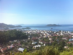
Sibolga (formerly sometimes Siboga) is a city and a port located in the natural harbour of Sibolga Bay on the west coast of North Sumatra province, in Indonesia.

Contents

The city is located on the western side of North Sumatra facing the Indian Ocean, is a transit harbour to Nias Island, and was hard hit during the 2004 Indian Ocean earthquake. Sibolga is also a semi-enclave within Central Tapanuli Regency, as Sibolga borders Central Tapanuli Regency in the north, east, and south, while it borders the Mentawai Strait in the west.

The city has an area of only 10.77 km2 and is the smallest city by land area in Indonesia. [2] It had a population of 84,444 at the 2010 census [3] and 89,584 at the 2020 census; [4] the official estimate as at mid 2023 was 91,265 - comprising 45,839 males and 45,426 females. [1]

Administrative districts

The city is divided into four districts (kecamatan), tabulated below with their areas and their populations at the 2010 census [3] and the 2020 census, [4] together with the official estimates as of mid-2023. [1] The table also includes the number of administrative villages (all classed as urban kelurahan) in each district and its postcodes.

Kode
Wilayah
Name of
District
(kecamatan)
Area
in
km2
Pop'n
census
2010
Pop'n
census
2020
Pop'n
estimate
mid 2023
No.
of
villages
Post
codes
12.73.01Sibolga Utara
(North Sibolga)
3.3319,97021,38321,831522511
-22514
12.73.02Sibolga Kota
(Sibolga Town)
2.7314,30415,17215,448422521
-22524
12.73.03Sibolga Selatan
(South Sibolga)
3.1430,08233,34634,177422533
-22538
12.73.04Sibolga Sambas1.5720,12519,68319,809422531
-22535
Totals10.7784,44189,58491,26517

History

Poncan Ketek Island (Small Poncan Island) in Sibolga Bay was once the location of a fort, with British, Dutch, French, and American traders passing through. It is thought Stamford Raffles passed through before he moved to Bengkulu in southern Sumatra. From Bengkulu Raffles, after relinquishing the port to the Dutch, established the trade port that became Singapore.

At some point between 1890 and 1920, there was a major fire in the city, which was presumably mostly built from wood from the surrounding mountains (shown partly denuded in the 1928 panorama below).

After the Japanese invasion of Sumatra in 1942, a makeshift prison described as a "civilian camp" was set up at Taroetoengweg, in the city center, from 16 March to 4 May 1942. It first housed 10 "European" men from in and around Sibolga, who were then joined on April 24 by another 10 men from the island of Nias. On May 4 they were taken to the Native Secondary School for Boys in Pearadja (Taroetoeng), located in the mountains behind Sibolga. [5]

Transport and tourism

Buses are available from Medan, Parapat, and Padang. Ferries from here service the outlying islands to the west, Simeulue and Nias, as well as the rest of Indonesia. Sibolga is a step-off point for trade and passenger boats to Nias Island. The local airport is Ferdinand Lumban Tobing Airport.

Climate

This area has a tropical rainforest climate with no real dry season. Regions with this climate typically feature tropical rainforests, and are designated by the Köppen climate classification as "Af". [6]

Climate data for Sibolga
MonthJanFebMarAprMayJunJulAugSepOctNovDecYear
Mean daily maximum °C (°F)31
(87)
31
(88)
31
(88)
31
(87)
31
(88)
31
(88)
31
(87)
30
(86)
29
(85)
30
(86)
30
(86)
31
(87)
31
(87)
Mean daily minimum °C (°F)23
(74)
23
(74)
23
(74)
24
(75)
24
(75)
23
(74)
23
(73)
23
(73)
23
(73)
23
(73)
23
(74)
23
(73)
23
(74)
Average precipitation mm (inches)300
(11.8)
280
(11.0)
390
(15.4)
420
(16.5)
310
(12.2)
230
(9.1)
280
(11.0)
350
(13.8)
370
(14.6)
490
(19.3)
450
(17.7)
420
(16.5)
4,290
(168.9)
Source: Weatherbase [7]

Related Research Articles

<span class="mw-page-title-main">North Sumatra</span> Province of Indonesia

North Sumatra is a province of Indonesia located in the northern part of the island of Sumatra. Its capital and largest city is Medan. It is bordered by Aceh on the northwest and Riau and West Sumatra on the southeast, with two different coastlines located on the Indian Ocean and the Strait of Malacca, and a maritime border with Malaysia to the east. North Sumatra is Indonesia's fourth most populous province after West Java, East Java, and Central Java, and the third-largest province on the island of Sumatra after the neighboring Riau. It covers an area of 72,981 km2, which is approximately the same size as Sierra Leone or Scotland or Maine.

<span class="mw-page-title-main">Jambi</span> Province of Indonesia

Jambi is a province of Indonesia. It is located on the east coast of central Sumatra and stretches to the Barisan Mountains in the west. Its capital and largest city is also called Jambi. It is bordered by the provinces of Riau to the north, West Sumatra to the west, Bengkulu to the southwest, South Sumatra to the south, and shares a maritime border with the Riau Islands to the east and the Pacific Ocean to the east. The province has a land area of 49,026.58 km2, and a sea area of 3,274.95 km2. It had a population of 3,092,265 according to the 2010 census and 3,548,228 according to the 2020 census; the official estimate of population as of mid-2022 was 3,631,136.

<span class="mw-page-title-main">Bengkulu</span> Province of Indonesia

Bengkulu, historically known as Bencoolen, is a province of Indonesia. It is located on the southwest coast of Sumatra. It was formed on 18 November 1968 by separating out the area of the historic Bencoolen Residency from the province of South Sumatra under Law No. 9 of 1967 and was finalized by Government Regulation No. 20 of 1968. Spread over 20,130.21 km2, it is bordered by the provinces of West Sumatra to the north, Jambi to the northeast, Lampung to the southeast, and South Sumatra to the east, and by the Indian Ocean to the northwest, south, southwest, and west.

<span class="mw-page-title-main">Nias</span> Island off the west coast of Sumatra, Indonesia

Nias is an island located off the western coast of Sumatra, Indonesia. Nias is also the name of the archipelago of which the island is the centre, but also includes the Batu Islands to the south-east and the small Hinako Islands to the west. Nias Island covers an area of 5,573.27 km2 (2,151.85 sq mi). It is mostly a lowland area rising to around 800 m (2,600 ft) above sea level. There were 756,338 inhabitants on the island at the 2010 Census; at the 2015 Intermediate Census this had risen to 798,506 and the 2020 Census resulted in a total of 880,550. The official estimate as at mid 2023 was 930,294.

<span class="mw-page-title-main">Gunungsitoli</span> City in North Sumatra, Indonesia

Gunungsitoli is a city located in North Sumatra province, Indonesia, on the Indian Ocean island of Nias, west of Sumatra. Gunungsitoli is the island's only city and is the main hub for the island and surrounding smaller islands. Located on the north-eastern side of Nias island, the city was historically a series of fortifications made by the Dutch colonial administration in the 1600s to defend against frequent raids from Nias tribes, especially those from southern parts of the island. Until 1914, it was the only part of the island that was effectively controlled by the Dutch.

<span class="mw-page-title-main">Padangsidempuan</span> City in North Sumatra, Indonesia

Padangsidimpuan is a city in North Sumatra, Indonesia, and the former capital of South Tapanuli Regency, which surrounds the city. It has an area of 159.28 km2 and a population of 178,818 people at the 2000 census, which rose to 191,554 in the 2010 census and 225,105 at the 2020 Census; the official estimate as at mid 2023 was 236,217 - comprising 119,228 males and 116,989 females.

<span class="mw-page-title-main">Jambi (city)</span> City and capital of Jambi, Indonesia

Jambi is the capital and largest city of the Indonesian province of Jambi. Located on the island of Sumatra, the city is a busy port on the Batang Hari River and an oil- and rubber-producing centre. The city is located 26 km (16 mi) from the ruins of Muaro Jambi Temple Compounds, an important city in the ancient Srivijaya kingdom.

<span class="mw-page-title-main">Tanjungbalai (city)</span> City in North Sumatra, Indonesia

Tanjungbalai, also colloquially written as Tanjung Balai, is a city in North Sumatra province, Indonesia, on the estuary of the Asahan River. It has an area of 60.52 square kilometers (23.37 sq mi) and the sixth largest kota (urban) population in North Sumatra with 154,445 inhabitants in the 2010 census and 176,027 at the 2020 Census; the official estimate as at mid 2023 was 183,170 - comprising 92,715 males and 90,455 females. The town has a ferry terminal with services to Port Klang, Malaysia, and the city-island of Singapore.

<span class="mw-page-title-main">Langsa</span> City in Sumatra, Indonesia

Langsa, is a city in Aceh, Indonesia. It is located on the island of Sumatra. Apart from a small seacoast to the northeast, it borders Manyak Payed District of Aceh Tamiang Regency to the east and is otherwise surrounded by Birem Bayeun District of Aceh Timur Regency to the north, west and south. The city covers an area of 239.83 square kilometres and had a population of 148,945 at the 2010 Census ; this grew to 185,971 at the 2020 Census, and the official estimate as at mid 2023 was 194,730, comprising 97,579 males and 97,151 females.

<span class="mw-page-title-main">Pagar Alam</span> City in South Sumatra, Indonesia

Pagar Alam, is a city in South Sumatra, Indonesia. It was formerly part of Lahat Regency, from which it was separated as an independent city on 21 June 2001; before being established as an independent city, Pagar Alam was an administrative city within Lahat Regency. It has an area of 633.66 km2 and a population of 126,181 at the 2010 Census and 143,844 at the 2020 Census; the official estimate as at mid 2022 was 147,071.

<span class="mw-page-title-main">Lubuklinggau</span> City in South Sumatra, Indonesia

Lubuklinggau, is a city in South Sumatra, Indonesia. It has an area of 401.50 km² and had a population of 201,308 at the 2010 Census and 234,166 at the 2020 Census; the official estimate as at mid 2022 was 240,238. The city was formerly part of the Musi Rawas Regency from which it was separated on 21 June 2001.

<span class="mw-page-title-main">Serang</span> City and capital of Banten, Indonesia

Serang is a city and the capital of Banten province and was formerly also the administrative center of Serang Regency in Indonesia. The city is located towards the north of Banten province, on the island of Java; the north part of the city contains the coast zone facing onto Banten Bay, and includes the historical site of Old Banten, after which the province is named. Before Banten province was formed in 2000, Serang city was part of West Java province.

<span class="mw-page-title-main">South Bengkulu Regency</span> Regency in Bengkulu, Indonesia

South Bengkulu is a regency of Bengkulu Province, Indonesia, on the island of Sumatra. It originally comprised all of that part of Bengkulu Province situated to the southeast of the city of Bengkulu, but on 25 February 2003 this area was split into three parts, with the most southeastern districts split off to form a new Kaur Regency and the most northwestern districts split off to form a new Seluma Regency. The reduced South Bengkulu Regency now covers 1,186.10 km2, and had a population of 142,940 at the 2010 Census and 166,249 at the 2020 Census; the official estimate as at mid 2022 was 170,093. The regency's administrative centre is the coastal town of Manna.

<span class="mw-page-title-main">Mukomuko Regency</span> Regency in Bengkulu, Indonesia

Mukomuko is a regency of Bengkulu Province, Indonesia, on the island of Sumatra. It was originally part of the North Bengkulu Regency, but on 25 February 2003 that regency was split into two parts, the northwestern part created as a separate Mukomuko Regency. It covers a land area of 4,146.52 km2 and had a population of 155,753 at the 2010 census, which rose to 190,498 at the 2020 census; the official estimate as at mid 2022 was 196,571. The administrative centre of the Mukomuko Regency is Mukomuko town.

Bireuën or Bireun is an Indonesian town, the seat of the Bireuën Regency government in the Aceh Special Territory of Sumatra. Bireuen is located at 5°12′18″N96°42′06″E. The town covers an area of 16.91 km2, and it had a population of 44,604 at the 2010 Census and 47,670 at the 2020 Census; the official estimate as at mid 2022 was 47,983.

<span class="mw-page-title-main">Subulussalam</span> City in Sumatra, Indonesia

Subulussalam is a city in the south of Aceh province of Indonesia. It is located inland on the island of Sumatra. On 2 January 2007, the provincial government of Aceh declared Subulussalam to be an independent city as a result of the administration being separated from that of Aceh Singkil Regency. of which it was formerly a part. It is located at 2°38′32″N98°00′15″E. It covers an area of 1,391 km2, and it had a population of 67,446 at the 2010 Census and of 90,751 at the 2020 Census; the official estimate as in mid 2023 was 97,770. As a result, Subulussalam is the most sparsely-populated city in Indonesia, with a population density of only 70.3 people per km2.

<span class="mw-page-title-main">Central Tapanuli Regency</span> Regency in North Sumatra, Indonesia

Central Tapanuli Regency is a regency in North Sumatra province, Sumatra, Indonesia. The seat of regency government is at Pandan. The regency covers an area of 2,194.98 km2 and consists of a long extent of land along the western coast of North Sumatra, together with offshore islands of which the largest is Mursala Island; it had a population of 311,232 at the 2010 census and 365,177 at the 2020 Census; the official estimate as at mid 2023 was 386,895. The regency surrounds on the landward side the city of Sibolga, which is administratively separate from the regency.

<span class="mw-page-title-main">Gresik Regency</span> Metropolitan regency in Indonesia

Gresik Regency is a regency within East Java Province of Indonesia. As well as a large part of the northern and western suburbs of the city of Surabaya, it includes the offshore Bawean Island, some 125 km to the north of Java and Madura. The regency covers and an area of 1,193.76 km2, and it had a population of 1,177,042 at the 2010 Census and 1,311,215 at the 2020 Census; the official estimate as at mid 2022 was 1,332,664. The regency's administrative centre is the town of Gresik, about 25 km to the northwest of Surabaya. Gresik Regency is also part of Gerbangkertosusila, the metropolitan region of Surabaya.

<span class="mw-page-title-main">Arse, Indonesia</span> District in North Sumatra, Indonesia

Arse is a district in the South Tapanuli Regency, North Sumatra province of Sumatra, Indonesia. It is located in the northern part of the island of Sumatra, around 220 kilometres (140 mi) south-east of the city of Medan. The district of Arse lies to the south of Saipar Dolok Hole.

References

  1. 1 2 3 Badan Pusat Statistik, Jakarta, 28 February 2024, Kota Sibolga Dalam Angka 2024 (Katalog-BPS 1102001.1273)
  2. "5 Kota Terkecil di Indonesia, yang Paling Kecil Luasnya Hanya 10 KM Persegi!". VOI - Waktunya Merevolusi Pemberitaan (in Indonesian). Retrieved 19 November 2022.
  3. 1 2 Biro Pusat Statistik, Jakarta, 2011.
  4. 1 2 Badan Pusat Statistik, Jakarta, 2021.
  5. "Search in this website - East Indies camp archives".
  6. "Sibolga, Indonesia Köppen Climate Classification (Weatherbase)". Weatherbase.
  7. "Weatherbase.com". Weatherbase. 2013. Retrieved on October 5, 2013.

Commons-logo.svg Media related to Sibolga at Wikimedia Commons