South Nias Regency

Last updated
South Nias Regency
Kabupaten Nias Selatan
Logo Nias Selatan.JPG
Motto: 
Furai
("Preserve")
Lokasi Sumatra Utara Kabupaten Nias Selatan.svg
Country Indonesia
ProvinceSumatera Utara
Regency seat Teluk Dalam
Government
  Regent Sokhiatulö Laia  [ id ]
  Vice Regent Yusuf Nache  [ id ]
  Chairman of Council of RepresentativesElisati Halawa (PDI-P)
  Vice Chairmen of Council of RepresentativesFa'atulö Sarumaha (Nasdem) and Agustana Ndruru (Golkar)
Area
  Total
2,487.99 km2 (960.62 sq mi)
Population
 (mid 2024 estimate) [1]
  Total
389,957
  Density156.736/km2 (405.944/sq mi)
Time zone UTC+7 (WIB)
Website niasselatankab.go.id
Group of warriors in South Nias. Photo by Christiaan Benjamin Nieuwenhuis COLLECTIE TROPENMUSEUM Groepsportret met mannen in krijgskleding Zuid-Nias TMnr 60009097.jpg
Group of warriors in South Nias. Photo by Christiaan Benjamin Nieuwenhuis
Girls at an offering house at the entrance of a kampong in South Nias COLLECTIE TROPENMUSEUM Meisjes bij een offerhuisje bij de ingang van een kampong in Zuid-Nias TMnr 10000954.jpg
Girls at an offering house at the entrance of a kampong in South Nias
Female dancers COLLECTIE TROPENMUSEUM Studioportret van een groep dansende vrouwen uit Zuid-Nias TMnr 60042489.jpg
Female dancers

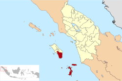
Nias Selatan (South Nias) Regency is a regency in North Sumatra province, Indonesia, created on 25 February 2003 by the division of the existing Nias Regency. The regency covers a land area of 2,487.99 square kilometres and according to the 2010 census had a population of 289,708; [2] the 2020 Census showed a population of 360,531, [3] while the official estimate for mid 2024 was 389,957 and the total projected for mid 2025 was 397,224. [1] Its administrative centre is the port of Teluk Dalam. Apart from the southern portion of Nias Island, the regency also includes the smaller Batu Islands (Pulau Pulau Batu) to the south, lying between Nias and Siberut; these islands occupy nearly half of the land area of the Regency, but have just 9% of its population.

Contents

Administrative districts

The regency was divided into eighteen districts (kecamatan) at the time of the 2010 Census, However, since 2010 seventeen additional districts have been created from parts of existing districts, notably in the Batu Islands where there are now seven districts compared with the three in 2010, but also on Nias Island itself where there are now twenty-eight districts within the Regency compared with fifteen in 2010. These are all tabulated below with their areas (in km2) and their populations at the 2010 Census, [2] and the 2020 Census, [3] together with the official estimates as at mid 2024 and the official projected figures for mid 2025. [1] They are grouped geographically (these groupings have no administrative significance). The table also includes the locations of the district administrative centres, the number of administrative villages in each district (a total of 459 classed as rural desa and 2 classed as urban kelurahan), and its postal code.

Kode
Wilayah
Name of
District
(kecamatan)
Area
in
km2
Pop'n
Census
2010
Pop'n
Census
2020
Pop'n
Estimate
mid 2024
Pop'n
Projected
mid 2025
Admin
centre
No.
of
villages
Post
code
12.14.04Hibala (a) [4] 225.759,6207,7168,4178,588Eho1722881
12.14.31Tanah Masa [5] 451.43(b)4,8075,2445,350Baluta1222887
12.14.05Pulau-Pulau Batu (c) [6]
(Batu Islands)
105.0916,3659,7319,9029,929Pasar Pulau Tello (d)
(Tello Island Market)
2222882
12.14.16Pulau Pulau Batu Timur [7]
(East Batu Islands)
372.052,4833,0913,3133,365Labuhan Hiu1022884
12.14.28Simuk (island) [8] 20.42(e)1,9341,9681,974Gobo622886
12.14.29Pulau Pulau Batu Barat [9]
(West Batu Islands)
21.06(e)2,3202,3612,367Bawositora922883
12.14.30Pulau Pulau Batu Utara [10]
(North Batu Islands)
6.30(e)3,8943,9633,974Silima Banua Marit1222885
Totals for Kepulauan Batu
(Batu Islands)
1,201.1028,46833,49335,16835,54788
12.14.06Teluk Dalam [11]
(Deep Bay)
41.3027,80125,48027,10327,478Pasar Teluk Dalam (d)1622865
12.14.18Fanayama [12] 82.4919,84418,20720,65621,283Bawo Mataluo1722865
12.14.12Toma [13] 41.268,01313,31616,00316,729Hilisataro1422865
12.14.10Maniamolo [14] 75.3213,43413,85513,78013,739Hilisimaetano1422865
12.14.13Mazino [15] 39.498,2748,7358,7698,763Hilizalo'otano1122865
12.14.32Luahagundre Maniamolo [16] 50.39(f)10,30711,69212,047Botohili Silambo1022868
12.14.33Onolalu [17] 25.37(f)8,4749,0129,136Siholi1022869
12.14.07Amandraya [18] 76.7617,09914,05915,98916,485Tuindrao2122866
12.14.15Aramo [19] 63.497,7629,97710,82911,035Hiliorudua1822866
12.14.24Ulususua [20] 57.18(f)10,66712,13212,508Fondrakoraya1222866
Totals for Nias Selatan Pusat
(Central South Nias)
553.05102,227133,077145,965149,203143
12.14.03Lahusa [21] 80.3634,91520,85822,92323,432Bawo Otalua2322874
12.14.25Sidua'ori [22] 62.40(f)11,35412,47812,755Hilidohona1122874
12.14.26Somambawa [23] 40.63(f)14,10215,49915,844Sihareo1422874
12.14.02Gomo [24] 37.5625,07810,54411,86712,203Orahili Gomo1122873
12.14.09Susua [25] 28.2314,96616,81117,29717,392Sifalago Susua1822873
12.14.17Mazo [26] 29.0315,12912,67412,45212,377Tetegawaai1022873
12.14.14Umbunasi [27] 32.817,8407,5837,4507,405Lawindra1122873
12.14.35Idanotae [28] 28.31(f)10,10211,36911,691Hilimbowo Idanotae1222878
12.14.34Ulu Idanotae [29] 14.33(f)7,1858,0868,314Fanedanu1122877
12.14.27Boronadu [30] 29.33(f)7,4838,4218,659Sifalago Gomo1022873
Totals for Nias Tenggara
(Southeast Nias)
382.9997,928118,696127,842130,072131
12.14.01Lolomatua [31] 21.5925,19811,07212,70213,124Hiliotalua1322867
12.14.19Ulunoyo [32] 48.99(f)13,03514,95415,451Orahili Ulunoyo1322867
12.14.20Huruna [33] 49.29(f)13,13515,06815,569Hilizoliga1722867
12.14.08Lolowa'u [34] 48.0330,0889,6459,6019,575Lolowau1422864
12.14.11Hilimegai [35] 40.155,7996,9267,3027,387Togizita1022864
12.14.21O'o'u [36] 73.16(f)8,8258,7858,761Simandraolo1122864
12.14.22Onohazumba [37] 28.45(f)6,8836,8526,833Orahili Huruna1022864
12.14.23Hilisalawa'ahe [38] 40.19(f)5,7445,7185,702Maluo1122864
Totals for Nias Barat Daya
(Southwest Nias)
349.8461,08575,26580,98282,40299
Totals for
South Nias
2,487.99289,708360,531389,957397,224Teluk Dalam461

Notes: (a) Hibala District now comprises 42 islands.
(b) The 2010 population of Tanah Masa District (comprising that part of Tanahmasa Island previously part of Hibala District) is included in the 2010 population of Hibala District.
(c) Pulau Pulau Batu District now comprises 35 islands. (d) There are 2 urban villages (kelurahan) - Pasar Teluk Dalam ("Deep Bay Market") in Teluk Dalam District, and Pasar Pulau Tello ("Tello Island Market") in Pulau Pulau Batu District.
(e) The 2010 populations of Simuk District (Simuk Island), Pulau Pulau Batu Barat District and Pulau Pulau Batu Utara District are included in the 2010 population of Pulau Pulau Batu District.
(f) The 2010 populations of the thirteen new districts on Nias Island are included in the 2010 populations of the districts from which they were split off.

The four new districts in the Batu Islands are Pulau Pulau Batu Barat (West Batu Islands), Pulau Pulau Batu Utara (North Batu Islands), Simuk (Simuk Island) and Tanah Masa (that part of Tanahmasa Island previously part of Hibala District). The thirteen new districts on Nias Island itself are Hilisalawa'ahe, O'o'u, Onohazumba, Ulususua, Ulunoyo, Huruna, Luahagundre Maniomolo, Onolalu, Boronadu, Sidua'ori, Somambawa, Ulu Idanotae, and Idanotae.

Tourism

Surfer in South Nias Unnamed Road, Kabupaten Nias Selatan, Sumatra Utara 22881, Indonesia - panoramio.jpg
Surfer in South Nias

South Nias Regency is a paradise for surfers with four surfing beaches:

References

  1. 1 2 3 Badan Pusat Statistik, Jakarta, 28 February 2025 (Katalog 1102001.1214)
  2. 1 2 Biro Pusat Statistik, Jakarta, 2011.
  3. 1 2 Badan Pusat Statistik, Jakarta, 2021.
  4. Badan Pusat Statistik, Jakarta, 26 September 2024, Kecamatan Hibala Dalam Angka 2024 (Katalog-BPS 1102001.1214010)
  5. Badan Pusat Statistik, Jakarta, 26 September 2024, Kecamatan Tanah Masa Dalam Angka 2024 (Katalog-BPS 1102001.1214011)
  6. Badan Pusat Statistik, Jakarta, 26 September 2024, Kecamatan Pulau-Pulau Batu Dalam Angka 2024 (Katalog-BPS 1102001.1214020)
  7. Badan Pusat Statistik, Jakarta, 26 September 2024, Kecamatan Pulau-Pulau Batu TimurDalam Angka 2024 (Katalog-BPS 1102001.1214021)
  8. Badan Pusat Statistik, Jakarta, 26 September 2024, Kecamatan Simuk Dalam Angka 2024 (Katalog-BPS 1102001.1214022)
  9. Badan Pusat Statistik, Jakarta, 26 September 2024, Kecamatan Pulau-Pulau Batu Barat Dalam Angka 2024 (Katalog-BPS 1102001.1214023)
  10. Badan Pusat Statistik, Jakarta, 26 September 2024, Kecamatan Pulau-Pulau Batu Utara Dalam Angka 2024 (Katalog-BPS 1102001.1214024)
  11. Badan Pusat Statistik, Jakarta, 26 September 2024, Kecamatan Teluk Dalam Dalam Angka 2024 (Katalog-BPS 1102001.1214030)
  12. Badan Pusat Statistik, Jakarta, 26 September 2024, Kecamatan Fanayama Dalam Angka 2024 (Katalog-BPS 1102001.1214031)
  13. Badan Pusat Statistik, Jakarta, 26 September 2024, Kecamatan Toma Dalam Angka 2024 (Katalog-BPS 1102001.1214032)
  14. Badan Pusat Statistik, Jakarta, 26 September 2024, Kecamatan Maniamolo Dalam Angka 2024 (Katalog-BPS 1102001.1214033)
  15. Badan Pusat Statistik, Jakarta, 26 September 2024, Kecamatan Mazino Dalam Angka 2024 (Katalog-BPS 1102001.1214034)
  16. Badan Pusat Statistik, Jakarta, 26 September 2024, Kecamatan Luahagundre Maniamolo Dalam Angka 2024 (Katalog-BPS 1102001.1214035)
  17. Badan Pusat Statistik, Jakarta, 26 September 2024, Kecamatan Onolalu Dalam Angka 2024 (Katalog-BPS 1102001.1214036)
  18. Badan Pusat Statistik, Jakarta, 26 September 2024, Kecamatan Amandraya Dalam Angka 2024 (Katalog-BPS 1102001.1214040)
  19. Badan Pusat Statistik, Jakarta, 26 September 2024, Kecamatan Aramo Dalam Angka 2024 (Katalog-BPS 1102001.1214041)
  20. Badan Pusat Statistik, Jakarta, 26 September 2024, Kecamatan Ulususua Dalam Angka 2024 (Katalog-BPS 1102001.1214042)
  21. Badan Pusat Statistik, Jakarta, 26 September 2024, Kecamatan Lahusa Dalam Angka 2024 (Katalog-BPS 1102001.1214050)
  22. Badan Pusat Statistik, Jakarta, 26 September 2024, Kecamatan Sidua'ori Dalam Angka 2024 (Katalog-BPS 1102001.1214051)
  23. Badan Pusat Statistik, Jakarta, 26 September 2024, Kecamatan Somambawa Dalam Angka 2024 (Katalog-BPS 1102001.1214052)
  24. Badan Pusat Statistik, Jakarta, 26 September 2024, Kecamatan Gomo Dalam Angka 2024 (Katalog-BPS 1102001.1214060)
  25. Badan Pusat Statistik, Jakarta, 26 September 2024, Kecamatan Susua Dalam Angka 2024 (Katalog-BPS 1102001.1214061)
  26. Badan Pusat Statistik, Jakarta, 26 September 2024, Kecamatan Mazo Dalam Angka 2024 (Katalog-BPS 1102001.1214062)
  27. Badan Pusat Statistik, Jakarta, 26 September 2024, Kecamatan Umbunasi Dalam Angka 2024 (Katalog-BPS 1102001.1214063)
  28. Badan Pusat Statistik, Jakarta, 26 September 2024, Kecamatan Idanotae Dalam Angka 2024 (Katalog-BPS 1102001.1214064)
  29. Badan Pusat Statistik, Jakarta, 26 September 2024, Kecamatan Ulu Idanotae Dalam Angka 2024 (Katalog-BPS 1102001.1214065)
  30. Badan Pusat Statistik, Jakarta, 26 September 2024, Kecamatan Boronadu Dalam Angka 2024 (Katalog-BPS 1102001.1214066)
  31. Badan Pusat Statistik, Jakarta, 26 September 2024, Kecamatan Lolomatua Dalam Angka 2024 (Katalog-BPS 1102001.1214070)
  32. Badan Pusat Statistik, Jakarta, 26 September 2024, Kecamatan Ulunoyo Dalam Angka 2024 (Katalog-BPS 1102001.1214071)
  33. Badan Pusat Statistik, Jakarta, 26 September 2024, Kecamatan Huruna Dalam Angka 2024 (Katalog-BPS 1102001.1214072)
  34. Badan Pusat Statistik, Jakarta, 26 September 2024, Kecamatan Lolowa'u Dalam Angka 2024 (Katalog-BPS 1102001.1214080)
  35. Badan Pusat Statistik, Jakarta, 26 September 2024, Kecamatan Hilimegai Dalam Angka 2024 (Katalog-BPS 1102001.1214081)
  36. Badan Pusat Statistik, Jakarta, 26 September 2024, Kecamatan O'o'u Dalam Angka 2024 (Katalog-BPS 1102001.1214082)
  37. Badan Pusat Statistik, Jakarta, 26 September 2024, Kecamatan Onohazumba Dalam Angka 2024 (Katalog-BPS 1102001.1214083)
  38. Badan Pusat Statistik, Jakarta, 26 September 2024, Kecamatan Hilisalawa'ahe Dalam Angka 2024 (Katalog-BPS 1102001.1214084)
  39. "Pantai Sorake, Idaman Peselancar Dunia". December 7, 2011.
  40. Irwan Arfa (September 18, 2016). "South Nias, Paradise for Surfers".

0°46′12″N97°45′00″E / 0.7700°N 97.7500°E / 0.7700; 97.7500