Bonsall, California

Last updated

Bonsall, California
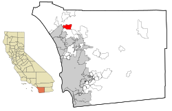
San Diego County California Incorporated and Unincorporated areas Bonsall Highlighted.svg
Location in San Diego County and the state of California
Usa edcp location map.svg
Red pog.svg
Bonsall, California
Location in the United States
Coordinates: 33°16′47″N117°11′37″W / 33.27972°N 117.19361°W / 33.27972; -117.19361
Country Flag of the United States (23px).png  United States
State Flag of California.svg  California
County San Diego
Area
[1]
  Total13.80 sq mi (35.74 km2)
  Land13.62 sq mi (35.29 km2)
  Water0.17 sq mi (0.45 km2)  1.28%
Elevation
[2]
180 ft (55 m)
Population
 (2020)
  Total4,546
  Density333.68/sq mi (128.83/km2)
Time zone UTC-8 (Pacific)
  Summer (DST) UTC-7 (PDT)
ZIP code
92003
Area codes 442/760
FIPS code 06-07498
GNIS feature IDs 1660358, 2407884

Bonsall is a census-designated place (CDP) in San Diego County, California. The population was 3,982 at the 2010 census, up from 3,401 at the 2000 census.

Contents

The Bonsall area was heavily affected by the Lilac Fire in December 2017, which burned 4,100 acres. [3]

Name

The area known as Bonsall was originally called Mount Fairview and had a post office by that name from December 28, 1871, to December 28, 1880. [4] It received a post office in 1881 under the name Osgood, after California Southern Railroad chief engineer Joseph O. Osgood; the renaming was supposedly an unsuccessful attempt to convince Osgood to build the railroad through the San Luis Rey River Valley (the rail line eventually followed the Santa Margarita River instead). Following a contest, the town was renamed Bonsall in 1890, after local minister James A. Bonsall. [5]

Geography

Bonsall is just east of Oceanside and Camp Pendleton, north of Vista and northwest of Hidden Meadows.

According to the United States Census Bureau, the CDP has a total area of 13.6 square miles (35 km2). The 13.4 square miles (35 km2) is land whereas 0.2 square miles (0.52 km2) or (1.28%) is water.

Demographics

Historical population
CensusPop.Note
2000 3,401
2010 3,98217.1%
2020 4,54614.2%
U.S. Decennial Census [6]
1850–1870 [7] [8] 1880-1890 [9]
1900 [10] 1910 [11] 1920 [12]
1930 [13] 1940 [14] 1950 [15]
1960 [16] 1970 [17] 1980 [18]
1990 [19] 2000 [20] 2010 [21]

2010

At the 2010 census Bonsall had a population of 3,982. The population density was 293.5 inhabitants per square mile (113.3/km2). The racial makeup of Bonsall was 3,194 (80.2%) White, 67 (1.7%) African American, 28 (0.7%) Native American, 138 (3.5%) Asian, 10 (0.3%) Pacific Islander, 376 (9.4%) from other races, and 169 (4.2%) from two or more races. Hispanic or Latino of any race were 893 people (22.4%). [22]

The census reported that 3,967 people (99.6% of the population) lived in households, 15 (0.4%) lived in non-institutionalized group quarters, and no one was institutionalized.

There were 1,542 households, 451 (29.2%) had children under the age of 18 living in them, 873 (56.6%) were opposite-sex married couples living together, 150 (9.7%) had a female householder with no husband present, 62 (4.0%) had a male householder with no wife present. There were 93 (6.0%) unmarried opposite-sex partnerships, and 12 (0.8%) same-sex married couples or partnerships. 337 households (21.9%) were one person and 109 (7.1%) had someone living alone who was 65 or older. The average household size was 2.57. There were 1,085 families (70.4% of households); the average family size was 2.99.

The age distribution was 844 people (21.2%) under the age of 18, 278 people (7.0%) aged 18 to 24, 913 people (22.9%) aged 25 to 44, 1,262 people (31.7%) aged 45 to 64, and 685 people (17.2%) who were 65 or older. The median age was 44.1 years. For every 100 females, there were 96.7 males. For every 100 females age 18 and over, there were 98.6 males.

There were 1,683 housing units at an average density of 124.0 per square mile, of the occupied units 1,112 (72.1%) were owner-occupied and 430 (27.9%) were rented. The homeowner vacancy rate was 2.6%; the rental vacancy rate was 4.2%. 2,815 people (70.7% of the population) lived in owner-occupied housing units and 1,152 people (28.9%) lived in rental housing units.

2000

At the 2000 census there were 3,401 people, 1,285 households, and 947 families in the CDP. The population density was 252.4 inhabitants per square mile (97.5/km2). There were 1,357 housing units at an average density of 100.7 per square mile (38.9/km2). The racial makeup of the CDP was 84.00% White, 0.85% African American, 0.38% Native American, 2.76% Asian, 0.12% Pacific Islander, 9.73% from other races, and 2.15% from two or more races. Hispanic or Latino of any race were 21.43%. [23]

Of the 1,285 households 28.3% had children under the age of 18 living with them, 62.6% were married couples living together, 8.1% had a female householder with no husband present, and 26.3% were non-families. 19.8% of households were one person and 7.5% were one person aged 65 or older. The average household size was 2.65 and the average family size was 3.02.

The age distribution was 23.2% under the age of 18, 7.1% from 18 to 24, 26.1% from 25 to 44, 27.1% from 45 to 64, and 16.5% 65 or older. The median age was 41 years. For every 100 females, there were 99.6 males. For every 100 females age 18 and over, there were 100.7 males.

The median household income was $60,625 and the median family income was $61,761. Males had a median income of $43,250 versus $29,688 for females. The per capita income for the CDP was $35,942. About 6.5% of families and 6.5% of the population were below the poverty line, including 7.4% of those under age 18 and 6.0% of those age 65 or over.

Education

Bonsall is served by the Bonsall Unified School District [24] consisting of three elementary schools, a middle school, and a high school. Joseph Clevenger has served as superintendent since July 1, 2021.

Politics

In the California State Legislature, Bonsall is in the 38th Senate District , represented by Democrat Catherine Blakespear, and in the 75th Assembly District , represented by Republican Marie Waldron. [25]

In the United States House of Representatives, Bonsall is in California's 48th congressional district , represented by Republican Darrell Issa. [26]

In June 1988, Bonsall-area voters defeated a ballot initiative to create a Community Services District ("CSD") after opponents argued that the boundaries included too many county taxpayers who more closely associated with neighboring cities Vista and Fallbrook rather than the unincorporated Bonsall community. [27]

Related Research Articles

<span class="mw-page-title-main">Alpine Village, California</span> Census-designated place in California, United States

Alpine Village is a census-designated place (CDP) in Alpine County, California, United States. The population was 114 at the 2010 census, down from 136 at the 2000 census.

<span class="mw-page-title-main">Auberry, California</span> Census-designated place in California, United States

Auberry is a census-designated place (CDP) in Fresno County, California, United States. The population was 2,369 at the 2010 census, up from 2,053 at the 2000 census. Auberry is located on Little Sandy Creek 9.5 miles (15 km) west of Shaver Lake Heights, at an elevation of 2,018 feet (615 m).

<span class="mw-page-title-main">Biola, California</span> Census-designated place in California, United States

Biola is a census-designated place (CDP) in Fresno County, California, United States. The population was 1,623 at the 2010 census, up from 1,037 in 2000. Biola is located 6 miles (9.7 km) north-northeast of Kerman, at an elevation of 253 feet.

<span class="mw-page-title-main">Bowles, California</span> Census-designated place in California, United States

Bowles is a census-designated place (CDP) in Fresno County, California, United States. The population was 166 at the 2010 census, down from 182 at the 2000 census. Bowles is located 11 miles (18 km) south of downtown Fresno, at an elevation of 279 feet.

<span class="mw-page-title-main">Cantua Creek, California</span> Census-designated place in California, United States

Cantua Creek is a census-designated place (CDP) in Fresno County, California, United States. As of the 2010 census, the population was 466, down from the 655 reported at the 2000 census. Cantua Creek is located 11 miles (18 km) south-southwest of Tranquillity, at an elevation of 295 feet.

<span class="mw-page-title-main">Bayview, Humboldt County, California</span> Census-designated place in California, United States

Bayview is a census-designated place (CDP) located adjacent to the City of Eureka in Humboldt County, California, United States. Its population is 2,619 as of the 2020 census, up from 2,510 from the 2010 census. Many locals consider this area as part of "Pine Hill."

<span class="mw-page-title-main">Clearlake Oaks, California</span> Census-designated place in California, United States

Clearlake Oaks is a census-designated place (CDP) in Lake County, California, United States. It is located on the northeast of Clear Lake, 8 miles (13.8 km) northwest of the town of Clearlake, at an elevation of 1,335 feet. The population was 2,359 at the 2010 census, down from 2,402 at the 2000 census.

<span class="mw-page-title-main">Bootjack, California</span> Unincorporated community in California, United States

Bootjack is an unincorporated community and census-designated place in Mariposa County, California, United States. The population was 661 at the 2020 census, down from 960 in 2010 and 1,588 in 2000, largely due to reductions in the area of the CDP.

<span class="mw-page-title-main">Aromas, California</span> Census-designated place in California, United States

Aromas is an unincorporated community and census-designated place (CDP) in Monterey County and San Benito County, California, United States. The population was 2,708 at the 2020 census.

<span class="mw-page-title-main">Bradley, California</span> Unincorporated community in California, United States

Bradley is an unincorporated community and census-designated place (CDP) in Monterey County, California, on the Salinas River 14 miles (23 km) south-southeast of San Ardo and 20 miles (32 km) north of Paso Robles. Bradley sits at an elevation of 548 feet (167 m). The population was 69 at the 2020 census, down from 93 at the 2010 census.

<span class="mw-page-title-main">Belden, California</span> Census-designated place in California, United States

Belden is a census-designated place (CDP) in Plumas County, California, United States. Belden is located on the Feather River Route and the North Fork Feather River, 7 miles (11.3 km) southwest of Caribou. The population was 22 at the 2010 census, down from 26 in 2000.

<span class="mw-page-title-main">Big River, California</span> Census-designated place in California, United States

Big River is a census-designated place (CDP) in San Bernardino County, California, United States. The population was 1,084 at the 2020 census, down from 1,327 at the 2010 census.

<span class="mw-page-title-main">Bluewater, California</span> Census-designated place in California, United States

Bluewater is a census-designated place (CDP) in San Bernardino County, California, United States. The population was 172 at the 2010 census, down from 265 at the 2000 census.

<span class="mw-page-title-main">Camp Pendleton Mainside, California</span> Census-designated place in California, United States

Camp Pendleton Mainside is a census-designated place (CDP) in San Diego County, California, located at the southeast corner of the Marine Corps Base Camp Pendleton. Per the 2020 census, the population was 9,683. It was formerly known as Camp Pendleton North, but its name was changed for the 2020 Census. Along with Camp Pendleton South, it is one of two CDPs located on the base.

<span class="mw-page-title-main">Camp Pendleton South, California</span> Census-designated place in California, United States

Camp Pendleton South is a census-designated place (CDP) in San Diego County, California, located at the southwest corner of the Marine Corps Base Camp Pendleton. The population was 10,616 at the 2010 census, up from 8,854 at the 2000 census. Much of the population are residents of Camp Pendleton barracks situated in the area, as well as housing communities for married Marine and Navy personnel and their families. It, along with Camp Pendleton Mainside CDP, is one of two CDPs on the base.

<span class="mw-page-title-main">Country Club, California</span> Census-designated place in California, United States

Country Club is a census-designated place (CDP) in San Joaquin County, California, United States. The population was 9,379 at the 2010 census, down from 9,462 at the 2000 census. It comprises an unincorporated "island" within the City of Stockton.

<span class="mw-page-title-main">Highlands-Baywood Park, California</span> Unincorporated community in California, United States

Highlands-Baywood Park is an unincorporated community and former census designated place (CDP) in in San Mateo County, California, United States. The population was 4,027 at the 2010 census.

Bret Harte is a census-designated place (CDP) in Stanislaus County, California, United States. The population was 5,152 at the 2010 census, down from 5,161 at the 2000 census. It is part of the Modesto Metropolitan Statistical Area. It is named for the American poet and short story writer, Bret Harte, best known for his writings about the California Gold Rush.

<span class="mw-page-title-main">Bystrom, California</span> Census-designated place in California, United States

Bystrom is a census-designated place (CDP) in Stanislaus County, California, United States. The population was 4,008 at the 2010 census, down from 4,518 at the 2000 census. It is part of the Modesto Metropolitan Statistical Area.

<span class="mw-page-title-main">China Lake Acres, California</span> Census-designated place in California, United States

China Lake Acres is a census-designated place (CDP) in Kern County, California, United States. The population was 1,876 at the 2010 census, up from 1,761 at the 2000 census.

References

  1. "2020 U.S. Gazetteer Files". United States Census Bureau. Retrieved October 30, 2021.
  2. "Bonsall". Geographic Names Information System . United States Geological Survey, United States Department of the Interior . Retrieved February 5, 2015.
  3. Figueroa, Teri (December 12, 2017). "Lilac fire 95 percent contained". San Diego Union-Tribune . Retrieved December 13, 2017.
  4. Frickstad, Walter N., A Century of California Post Offices 1848-1954, Philatelic Research Society, Oakland, CA. 1955, pp. 147-158.
  5. Fetzer, James. San Diego County Place Names A to Z. San Diego: Sunbelt, 2005.
  6. "Decennial Census by Decade". United States Census Bureau .
  7. "1870 Census of Population - Population of Civil Divisions less than Counties - California - Almeda County to Sutter County" (PDF). United States Census Bureau .
  8. "1870 Census of Population - Population of Civil Divisions less than Counties - California - Tehama County to Yuba County" (PDF). United States Census Bureau .
  9. "1890 Census of Population - Population of California by Minor Civil Divisions" (PDF). United States Census Bureau .
  10. "1900 Census of Population - Population of California by Counties and Minor Civil Divisions" (PDF). United States Census Bureau .
  11. "1910 Census of Population - Supplement for California" (PDF). United States Census Bureau .
  12. "1920 Census of Population - Number of Inhabitants - California" (PDF). United States Census Bureau .
  13. "1930 Census of Population - Number and Distribution of Inhabitants - California" (PDF). United States Census Bureau .
  14. "1940 Census of Population - Number of Inhabitants - California" (PDF). United States Census Bureau .
  15. "1950 Census of Population - Number of Inhabitants - California" (PDF). United States Census Bureau .
  16. "1960 Census of Population - General population Characteristics - California" (PDF). United States Census Bureau .
  17. "1970 Census of Population - Number of Inhabitants - California" (PDF). United States Census Bureau .
  18. "1980 Census of Population - Number of Inhabitants - California" (PDF). United States Census Bureau .
  19. "1990 Census of Population - Population and Housing Unit Counts - California" (PDF). United States Census Bureau .
  20. "2000 Census of Population - Population and Housing Unit Counts - California" (PDF). United States Census Bureau .
  21. "2010 Census of Population - Population and Housing Unit Counts - California" (PDF). United States Census Bureau .
  22. "2010 Census Interactive Population Search: CA - Bonsall CDP". U.S. Census Bureau. Archived from the original on July 15, 2014. Retrieved July 12, 2014.
  23. "U.S. Census website". United States Census Bureau . Retrieved January 31, 2008.
  24. "Bonsall Unified School District".
  25. "Statewide Database". UC Regents. Archived from the original on February 1, 2015. Retrieved February 5, 2015.
  26. "California's 48th Congressional District - Representatives & District Map". Civic Impulse, LLC.
  27. June 1988 editions of Vista Press and Oceanside Blade-Tribune