Flinn Springs, California

Last updated

Flinn Springs is an unincorporated community in the East County region of San Diego County, California.

Contents

Old buildings in Flinn Springs Flynn Springs old buildings.jpg
Old buildings in Flinn Springs
Atchison, Topeka and Santa Fe Railway car in Flinn Springs Flynn Springs caboose.jpg
Atchison, Topeka and Santa Fe Railway car in Flinn Springs

History

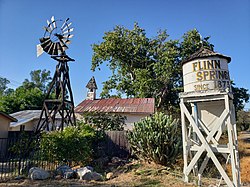
Flinn Springs is named for early settler James Ebenezer Flinn, a native of Missouri who moved to the area and established a farm prior to 1874. Sometimes Flinn's father, Dr. William E. Flinn, is credited as the founder of Flinn Springs instead. The settlement was also known as "La Viñita" (Spanish for "the little vineyard") because the Flinns made and sold wine at their farm. [1]

Geography

Flinn Springs straddles Interstate 8, which runs from east to west through the region. U.S. Route 80 passed through Flinn Springs from 1926 until the route was decommissioned in California in 1964. The historic highway continues to serve as the community's main thoroughfare.

Flinn Springs neighbors Lakeside to the west, Harbison Canyon to the south, and Alpine to the east. The community sits at an elevation of 1,063 feet. [2]

Related Research Articles

<span class="mw-page-title-main">Harbison Canyon, California</span> Census-designated place in California, United States

Harbison Canyon is a census-designated place (CDP) in San Diego County, California. Harbison Canyon had a population of 4,048 as of the 2020 census, up from 3,841 as of the 2000 census.

<span class="mw-page-title-main">Cuyamaca, California</span>

Cuyamaca is a region of eastern San Diego County. It lies east of the Capitan Grande Indian Reservation in the western Laguna Mountains, north of Descanso and south of Julian. Named for the 1845 Rancho Cuyamaca Mexican land grant, the region is now dominated by the 26,000-acre (110 km2) Cuyamaca Rancho State Park. Within the park is the prominent Cuyamaca Peak, the second-highest mountain in San Diego County at 6,512 feet (1,984.9 m).

<span class="mw-page-title-main">Boulevard, California</span> Census-designated place in California, United States

Boulevard is a census-designated place (CDP) in the Mountain Empire area of southeastern San Diego County, California. At the 2010 census, it had a population of 315. The area is rural high desert along the Mexican border near the eastern extent of San Diego County.

<span class="mw-page-title-main">Campo, California</span> Place in California, United States

Campo is an unincorporated community in the Mountain Empire area of southeastern San Diego County, California, United States. The population was 2,684 at the 2010 census. For statistical purposes, the United States Census Bureau has defined Campo as a census-designated place (CDP). The census definition of the area may not precisely correspond to local understanding of the area with the same name.

Los Coches Creek is a 9.4-mile-long (15.1 km) tributary of the San Diego River in southern San Diego County, California.

<span class="mw-page-title-main">Mexican Federal Highway 1</span> Highway in Mexico

Federal Highway 1 is a free (libre) part of the federal highway corridors of Mexico, and the highway follows the length of the Baja California Peninsula from Tijuana, Baja California, in the north to Cabo San Lucas, Baja California Sur, in the south. The road connects with Via Rapida, which merges into the American Interstate 5 (I-5) at the San Ysidro Port of Entry, which crosses the international border south of San Ysidro, California.

<span class="mw-page-title-main">Casa de Oro, California</span> Unincorporated community in California, United States

Casa de Oro is a neighborhood in east San Diego County, California, United States. The community, twelve miles east of San Diego, is in the unincorporated town of Spring Valley and an unincorporated part of La Mesa. The United States Census Bureau has also divided the neighborhood between two census-designated places (CDPs), Spring Valley CDP and Casa de Oro-Mount Helix CDP. Casa de Oro's main thoroughfare is Campo Road.

<span class="mw-page-title-main">Campo Indian Reservation</span> Indian reservation in California, United States

The Campo Indian Reservation is home to the Campo Band of Diegueño Mission Indians, also known as the Campo Kumeyaay Nation, a federally recognized tribe of Kumeyaay people in the southern Laguna Mountains, in eastern San Diego County, California. The reservation was founded in 1893 and is 16,512 acres (66.82 km2).

<span class="mw-page-title-main">Mojave Road</span> Historical trails and roads

The Mojave Road, also known as Old Government Road, is a historic route and present day dirt road across what is now the Mojave National Preserve in the Mojave Desert in the United States. This rough road stretched 147 miles (237 km) from Beale's Crossing, to Fork of the Road location along the north bank of the Mojave River where the old Mojave Road split off from the route of the Old Spanish Trail/Mormon Road.

<span class="mw-page-title-main">Naval Base Coronado</span>

Naval Base Coronado (NBC) is a consolidated Navy installation encompassing eight military facilities stretching from San Clemente Island, located seventy miles west of San Diego, California, in Los Angeles County, California, to the Mountain Warfare Training Camp Michael Monsoor and Camp Morena, located sixty miles east of San Diego.

<span class="mw-page-title-main">El Cajon Boulevard</span> Major thoroughfare through San Diego, La Mesa and El Cajon, California and called "The Boulevard"

El Cajon Boulevard is a major east–west thoroughfare through San Diego, La Mesa and El Cajon, California. Before the creation of Interstate 8 it was the principal automobile route from San Diego to El Cajon, the Imperial Valley, and points east as U.S. Route 80; it is now signed as a business loop of Interstate 8.

Dehesa is a populated place in San Diego County, California. Dehesa is located along the Sweetwater River and Dehesa Valley between Harbison Canyon, Crest, Alpine, and Granite Hills.

The United States Border Patrol operates 71 traffic checkpoints, including 33 permanent traffic checkpoints, near the Mexico–United States border. The stated primary purpose of these inspection stations is to deter illegal immigration and smuggling activities. After the September 11 attacks in 2001, they took on the additional role of terrorism deterrence. These checkpoints are located between 25 and 75 miles of the Mexico–United States border along major U.S. highways; near the southern border of the contiguous United States. Their situation at interior locations allow them to deter illegal activities that may have bypassed official border crossings along the frontier. The checkpoints are divided among nine Border Patrol sectors. There are a number of these checkpoints near the northern border of the contiguous U.S. as well, within 100 miles (160 km) of the Canada–U.S. border.

There are 34 routes assigned to the "S" zone of the California Route Marker Program, which designates county routes in California. The "S" zone includes county highways in Imperial, Orange, Riverside, San Diego, and Santa Barbara counties.

<span class="mw-page-title-main">East County, San Diego</span> Region of the San Diego Metro Area in San Diego County

East County is a region of San Diego County, California, east of San Diego.

<span class="mw-page-title-main">Mountain Empire, San Diego</span> Region of the San Diego Metro Area in San Diego County

The Mountain Empire is a rural area in southeastern San Diego County, California. The Mountain Empire subregion consists of the backcountry communities in southeastern San Diego County. The area is also sometimes considered part of the East County region of San Diego County.

The Perris Block is the central block of three major fault-bounded blocks of the northern part of the Peninsular Ranges. The Perris Block lies between the Santa Ana Block to the west and the San Jacinto Block to the east. The Perris Block, was named by Walter A. English in 1925 for the city of Perris, located near the center of the block.

The Carrizo Creek and Carrizo Wash in California are a stream and an arroyo that the stream flows into, in San Diego County, California and Imperial County, California.

Jacumba Valley is a valley in San Diego and Imperial Counties, California. Its head is at 32°37′00″N116°10′07″W Carrizo Creek has its source in Jacumba Valley, 1.2 miles north of the California-Mexico State boundary, at 32°38′09″N116°07′05″W at an elevation of 3,210 feet, on the west side of the divide between Jacumba Valley and the valley of upper Boulder Creek. Carrizo Creek flows west then north northwest through Jacumba Valley to its mouth at the head of Carrizo Gorge. Just south of the Jacumba and In-ko-pah Mountains, the terrain consists of large, flat desert plains and hills of granite boulders. The wider region, including the Jacumba Wilderness, which sits just east of the valley, has been greatly affected by the construction of the US/Mexico border and has become a site of great numbers of migrations along migrant paths.

Devils Canyon is a steep canyon in the Jacumba Mountains in Imperial and San Diego County, California, United States. Its mouth is located at an elevation of 1,109 feet (338 m) in Imperial County. Its head is at an elevation of 3,560 feet (1,090 m) at 32°41′06″N116°08′42″W in the Jacumba Mountains in San Diego County.

References

  1. Fetzer, Leland (August 16, 2005). San Diego County Place Names, A to Z. Sunbelt Publications, Inc. ISBN   9780932653734.
  2. "Flinn Springs, California" . Retrieved 13 August 2014.

Coordinates: 32°51′18″N116°51′09″W / 32.85500°N 116.85250°W / 32.85500; -116.85250