Cervecería Cuauhtémoc Moctezuma (Cervecería Cuauhtémoc Moctezuma / Heineken México) is a major brewery based in Monterrey, Nuevo León, Mexico, founded in 1890. It is a subsidiary of Heineken International.

The San Diego and Arizona Eastern Railway Company is a short-line American railroad founded in 1906 as the San Diego and Arizona Railway (SD&A) by sugar magnate, developer, and entrepreneur John D. Spreckels. Dubbed "The Impossible Railroad" by many engineers of its day due to the immense logistical challenges involved, the line was established in part to provide San Diego with a direct rail link to the east by connecting with the Southern Pacific Railroad lines in El Centro, California.
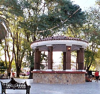
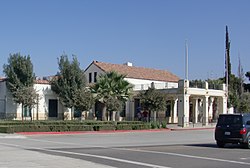
Tecate is a city in Tecate Municipality, Baja California. It is on the across the Mexico-US border from Tecate, California. As of 2019, the city had a population of 108,860 inhabitants, while the metropolitan area has a population of 132,406 inhabitants. Tecate is part of the San Diego-Tijuana metropolitan area and the largest city between Tijuana and Mexicali. Tecate is a regional economic hub and popular tourist destination, known as home to the Tecate Port of Entry and to Tecate beer.

Tecate is a municipality in the Mexican state of Baja California. Its municipal seat is located in the city of Tecate. According to the 2020 census, it had a population of 108,440 inhabitants. The municipality has an area of 3,079.0 km².

Tijuana Municipality is a municipality in the Mexican state of Baja California. Its municipal seat is located in the city of Tijuana. According to the 2020 census, the municipality had a population of 1,922,523. Luis Arturo González Cruz of the MORENA is the current municipal president. The municipality comprises the largest part of the Tijuana metropolitan area.
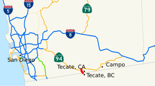
State Route 188, also known as Tecate Road, is an approximately two-mile (3 km) state highway in the U.S. state of California that connects State Route 94 in San Diego County with the Mexico – United States border. Its southern terminus is at the border near Tecate, Baja California and its northern terminus with SR 94 is near Tecate, California. The route was assigned in the area in 1972, and has remained intact since.
In Mexico, some municipalities and Mexico City are divided into boroughs for administrative purposes. Boroughs are known as delegaciones, or in the case of Mexico City. Boroughs can either be second-level semi-autonomous administrative divisions or third-level non-autonomous administrative divisions. The limits, nature and competencies of boroughs are usually described in the constitutions of the states they are part of, or in the laws enacted by the municipality itself, and may differ from municipality to municipality.
Tecate Airport is a closed, paved airstrip located South of Tecate in Municipality of Tecate, Baja California, Mexico. The city is on the U.S.-Mexico border. The airport is now no longer operated as an airport, and the runway is now used as a race track for street racing competitions.

Cupressus forbesii, now reclassified by some as Hesperocyparis forbesii, and with the common names Tecate cypress or Forbes' cypress, is a species of cypress native to southwestern North America.

XHPRS-FM is a commercial FM radio station transmitting from Tecate, Baja California, and serving the Tijuana-San Diego metropolitan area. The station's signal is owned and operated by Media Sports de México. The Transmitter is located on Cerro Bolla.
Valle de las Palmas is located between two hamlets Espuela and Seco in the municipalities of Tijuana and Tecate, Baja California, Mexico. It is the site of a long-term planned urban development which would take advantage of proximity to the existing cities of Tijuana to the north west and Mexicali to the north east to create a similar sized city of one million people by the year 2030, on Mexican Federal Highway 3 around an existing industrial park and university campus Unidad Valle De Las Palmas. The first project in Valle de las Palmas, named Valle San Pedro, is proposed by the Mexican Federal Government, the State of Baja California, Urbi and Banobras. It has been certified as the first Integral Sustainable Urban Development or DUIS in Mexico, which establishes criteria in collaboration with Interamerican Development Bank IDB to evaluate projects that will receive inter-secretarial technical support and public investment. The locality reported a population of 1,860 inhabitants in the 2010 federal census. It is located at an altitude of 282 m. above sea level.

El Vallecito is an archaeological site located in the city of La Rumorosa, in the Tecate Municipality, Baja California, Mexico.

The Tijuana metropolitan area, and in Spanish the Zona Metropolitana de Tijuana, is located by the Pacific Ocean in Mexico. The 2010 census placed the Tijuana metropolitan area as the fifth largest city by population in the country with 1,751,302 persons. The census bureau defined metropolitan area comprises three municipalities: Tijuana, Tecate and Rosarito Beach. Yet sources commonly include Tecate Municipality in the metropolitan area as the urban area between Tijuana and Tecate grows, the commuting populace increases - ultimately further developing the southern areas of San Diego–Tijuana, and the three municipalities maintain strong relationships and cooperation.

The Autonomous University of Baja California (UABC) is a public institution of higher education in Baja California. Established in 1957, UABC has its headquarters located in the city of Mexicali.

La Rumorosa is a town in the municipality of Tecate, Baja California, Mexico. It has a population of 1,836 inhabitants. It lies on the road between Mexicali and Tecate, and it is directly across the international border from Jacumba Hot Springs, California. However, no official border crossing exists; the nearest official crossing is in Tecate. The La Rumorosa area contains Native American cave paintings, which are the primary tourist draw.

Baja California Railroad, Inc. (BJRR) is a class III railroad operating in the northwest of Baja California, interchanging with San Diego and Imperial Valley Railroad in San Ysidro, California. After rehabilitation efforts are completed on the Desert Line portion of the railroad, an interchange is also planned with the Union Pacific Railroad in Plaster City, California.

Tecate Peak is a mountain in San Diego County in the U.S. state of California. Tecate Peak is four miles west of Tecate, Baja California, and is about 1/2 mile north of the United States-Mexico border.
Cottonwood Creek is a major stream, about 36 miles (58 km) long, in southern San Diego County, California. It is part of the Tijuana River drainage basin.
Tecate Creek is a stream in northern Baja California, Mexico with its headwaters in southern San Diego County, California in the United States. It begins along the Tecate Divide in the In-Ko-Pah Mountains, near Live Oak Springs. The upper reaches of the stream in the US are known as Campo Creek. It flows southwest, crossing the Mexico–United States border at Canyon City, before flowing through the city of Tecate, Baja California. West of Tecate it flows through a gorge and briefly re-enters the US where it combines with Cottonwood Creek to form the Rio Alamar, a tributary of the Tijuana River which it joins in Central Tijuana.
Federal Highway 2D is a part of the federal highways corridors, and is the designation for toll highways paralleling Mexican Federal Highway 2. Seven road segments are designated Highway 2D, all but one in the state of Baja California, providing a toll highway stretching from Tijuana in the west to around Mexicali in the east; one in Sonora, between Santa Ana and Altar; and another between the cities of Matamoros and Reynosa in Tamaulipas.