
San Diego Country Estates, commonly referred to as the Estates, is a valley resort populace composed of several neighborhoods associated with the unincorporated community of Ramona, California. The Estates are a census-designated place in North County, a region of the San Diego metropolitan area. The Estates is just east of the North County city of Poway and southeast of Ramona; 38 miles (61 km) northeast of San Diego and 46 miles (74 km) from the regional center of Carlsbad. San Diego Country Estates had a population of 10,109 at the 2010 census, up from 9,262 at the 2000 census.
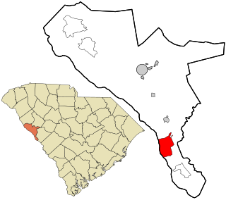
Modoc is a census-designated place (CDP) in McCormick County, South Carolina, United States. The population was 256 at the 2000 census, and 218 at the 2010 census, a decline of 14.8%.

The Mojave Road, also known as Old Government Road, is a historic route and present day dirt road across what is now the Mojave National Preserve in the Mojave Desert in the United States. This rough road stretched 147 miles (237 km) from Beale's Crossing, to Fork of the Road location along the north bank of the Mojave River where the old Mojave Road split off from the route of the Old Spanish Trail/Mormon Road.
The Barber Neighborhood is a working class residential neighborhood in Chico, California, generally south of Little Chico Creek and west of Park avenue. The Barber Neighborhood Association represents the interests of the neighborhood to the community. This neighborhood was originally the settlement of Barber, California built to house the employees of the adjacent Diamond Match Factory. The neighborhood was named after Ohio Columbus Barber, president of the Diamond Match Company. The neighborhood lies at an elevation of 190 feet. Today, the area is entirely within the city limits of Chico, and the Diamond Match property is designated for a future development called Barber Yard. Some of the notable and historic structures in the neighborhood are:
Whitewater is a census-designated place in Riverside County, California. It is directly off Interstate 10 halfway between North Palm Springs and Cabazon on the way from Palm Springs to Los Angeles. It is known as the site of the San Gorgonio Pass Wind Farm. The ZIP Code is 92282, and the community is inside area code 760. The population was 859 at the 2010 census. The elevation is 1,575 feet (480 m).
The United States Border Patrol operates 71 traffic checkpoints, including 33 permanent traffic checkpoints, near the Mexico–United States border. The stated primary purpose of these inspection stations is to deter illegal immigration and smuggling activities. After the September 11 attacks in 2001, they took on the additional role of terrorism deterrence. These checkpoints are located between 25 and 75 miles of the Mexico–United States border along major U.S. highways; near the southern border of the contiguous United States. Their situation at interior locations allow them to deter illegal activities that may have bypassed official border crossings along the frontier. The checkpoints are divided among nine Border Patrol sectors. There are a number of these checkpoints near the northern border of the contiguous U.S. as well, within 100 miles (160 km) of the Canada–U.S. border.
Midway is an unincorporated community in Alameda County, California, 6 miles (9.7 km) south-southeast of Altamont. It lies at an elevation of 358 feet. A post office operated in Midway from 1870 to 1918.

Suixi County is a county in the north of Anhui Province, China, bordering Henan province to the southeast. It is under the administration of Huaibei City.
The Twenty-Nine Palms Band of Mission Indians of California is a federally recognized tribe of Mission Indians with a reservation consisting of two sections, one located near the cities of Indio and Coachella in Riverside County, and the other in the city of Twentynine Palms in San Bernardino County, California. While many scholars regard the tribe as being Luiseño, the tribe itself identifies as being Chemehuevi.
Branson City or Branson is a ghost town in San Diego County, California. It lies at an elevation of 3996 feet. It is located on State Highway 78 at its junction with Pine Hills Road, about one mile west of Julian.
Kentwood-In-The-Pines is an unincorporated community, 0.8 miles (1.3 km) east-southeast of Julian in San Diego County, California.
Eastwood is a ghost town in San Diego County, California. It was located a mile northwest of Julian, near Eastwood Creek.
The Carrizo Creek and Carrizo Wash in California are a stream and an arroyo that the stream flows into, in San Diego County, California and Imperial County, California.
San Felipe Creek is a stream in Imperial and San Diego Counties of California. It arises in the Volcan Mountains of San Diego County 33°11′57″N116°37′35″W, and runs eastward, gathering the waters of most of the eastern slope of the mountains and desert of the county in the San Sebastian Marsh before it empties into the Salton Sea. It is probably the last remaining perennial natural desert stream in the Colorado Desert region. In 1974, the San Felipe Creek Area was designated as a National Natural Landmark by the National Park Service.
Witch Creek is a stream, and a tributary of Santa Ysabel Creek, in eastern San Diego County, California.
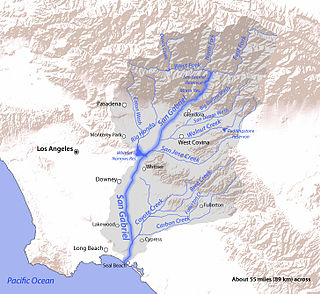
San Jose Creek is an intermittent, tributary stream of the San Gabriel River in Los Angeles County, California. The mouth of San Jose Creek is at an elevation of 194 feet at its confluence with the San Gabriel River, 3.5 miles (5.6 km) southwest of Bassett, California. Its source is at 960 feet near the Los Angeles County Fairplex, at 34°04′50″N117°45′38″W, where it has its confluence with Thompson Wash, actually a continuation of the creek into the San Gabriel Mountains. From Thompson Wash, San Jose Creek flows nearly 20 miles (32 km) westwards from Pomona into the San Gabriel River through the Pomona Valley and San Gabriel Valley. Because of its strategic location between the San Jose Hills and Puente Hills, the Union Pacific Railroad laid tracks along its route connecting Los Angeles with San Bernardino and Salt Lake City.
Snow Creek, also known as Snow Creek Village, is a small unincorporated community in Riverside County, California. It is located roughly northwest of Palm Springs, on the western edge of the Santa Rosa and San Jacinto Mountains National Monument, and roughly southeast of the San Gorgonio Pass. It is named after nearby Snow Creek.
Vallecito Wash is a wash part of Vallecito Creek, a tributary stream of Carrizo Creek, in San Diego County, California.
Cahuilla Creek is a tributary stream of Wilson Creek which is in turn a tributary of Temecula Creek, and the Santa Margarita River in Riverside County, California. Its mouth is at its confluence with Wilson Creek at an elevation of 2,106 feet (642 m). Its source is at 33°36′40″N116°40′10″W, at an elevation of 5,800 feet, on the west slope of Thomas Mountain 0.6 miles west-southwest of Tool Box Spring. It flows southwest through the Anza Valley and Cahuilla Valley in the Cahuilla Indian Reservation to Wilson Creek, 7 miles south-southwest of Cahuilla Mountain and 20 miles south-southeast of San Jacinto.
Huddleston Branch is a stream in Oregon County, in the Ozarks of southern Missouri. It is a tributary to Dry Creek.
