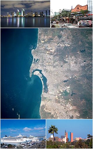
San Diego is a city in the U.S. state of California located alongside the Pacific Ocean in Southern California. With a population of over 1.3 million residents, the city is the eighth-most populous in the United States and the second-most populous in California. The city is located immediately adjacent to the Mexico–United States border and is the seat of San Diego County, which has a population of nearly 3.3 million people as of 2021. San Diego is known for its mild year-round Mediterranean climate, extensive beaches and parks, its long association with the United States Navy, and its recent emergence as a healthcare and biotechnology development center.

California is a U.S. state on the western coast of North America. Covering an area of 163,696 sq mi (423,970 km2), California is among the most geographically diverse states. The Sierra Nevada, the fertile farmlands of the Central Valley, and the arid Mojave Desert of the south are some of the major geographic features of this U.S. state. It is home to some of the world's most exceptional trees: the tallest, most massive, and oldest. It is also home to both the highest and lowest points in the 48 contiguous states. The state is generally divided into Northern and Southern California, although the boundary between the two is not well defined. San Francisco is decidedly a Northern California city and Los Angeles likewise a Southern California one, but areas in between do not often share their confidence in geographic identity. The US Geological Survey defines the geographic center of the state at a point near North Fork, California.

San Jacinto is a city in Riverside County, California. It is located at the north end of the San Jacinto Valley, with Hemet to its south and Beaumont, California, to its north. The mountains associated with the valley are the San Jacinto Mountains. The population was 44,199 at the 2010 census. The city was founded in 1870 and incorporated on April 20, 1888, making it one of the oldest cities in Riverside County.

Carlsbad is a coastal city in the North County region of San Diego County, California, United States. The city is 87 miles (140 km) south of downtown Los Angeles and 35 miles (56 km) north of downtown San Diego. As of the 2020 census, the population of the city was 114,746. Carlsbad is a popular tourist destination and home to many businesses in the golf industry.

Imperial Beach is a residential beach city in San Diego County, California, with a population of 26,137 at the 2020 United States census, down from 26,324 at the 2010 census. The city is the southernmost city in California and the West Coast of the United States. It is in the South Bay area of San Diego County, 14.1 miles (22.7 km) south of downtown San Diego and 5 miles (8 km) northwest of downtown Tijuana, Mexico.
La Mesa is a city in San Diego County, located nine miles east of Downtown San Diego in Southern California. The population was 61,121 at the 2020 census, up from 57,065 at the 2010 census. Its civic motto is "the Jewel of the Hills."

Palomar Mountain is a mountain ridge in the Peninsular Ranges in northern San Diego County. It is famous as the location of the Palomar Observatory and Hale Telescope, and known for the Palomar Mountain State Park.

The Cleveland National Forest encompasses 460,000 acres/720 sq mi (1,900 km2) of inland montane regions—approx. 60 miles from the Pacific Ocean—within the counties of San Diego, Riverside, and Orange, California. The landscape varies somewhat, with mostly chaparral canyons, arroyos and high desert, but dotted with meadows and oak and conifer forests. Near water sources, riparian environments and perennial aquatic plants attract native and migratory wildlife, such as at San Diego’s man-made Lake Cuyamaca. A generally warm and dry, inland-Mediterranean climate prevails over the forest, with the cooler months producing morning frost and snowfall. It is the southernmost U.S. National Forest of California. The area is administered by the U.S. Forest Service, a government agency within the United States Department of Agriculture, and is locally overseen by the Descanso, Palomar and Trabuco Ranger Districts.
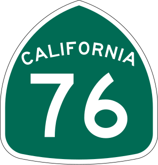
State Route 76 (SR 76) is a state highway 52.63 miles (84.70 km) long in the U.S. state of California. It is a much used east–west route in the North County region of San Diego County that begins in Oceanside near Interstate 5 (I-5) and continues east. The highway is a major route through the region, passing through the community of Bonsall and providing access to Fallbrook. East of the junction with I-15, SR 76 goes through Pala and Pauma Valley before terminating at SR 79.

Boulevard is a census-designated place (CDP) in the Mountain Empire area of southeastern San Diego County, California. At that time, it had a population of 359 at the 2020 United States census, up from 315 2010 United States census. The area is rural high desert along the Mexican border near the eastern extent of San Diego County.

Campo is an unincorporated community in the Mountain Empire area of southeastern San Diego County, California, United States. The population was 2,955 at the 2020 United States census, up from 2,684 at the 2010 census. For statistical purposes, the United States Census Bureau has defined Campo as a census-designated place (CDP). The census definition of the area may not precisely correspond to local understanding of the area with the same name.

Rancho Bernardo is a master-planned community in the northern hills of the city of San Diego, California.
Santa Ysabel, is an unincorporated community in the Santa Ysabel Valley of eastern San Diego County, in southern California.
Otay Mesa is a community in the southern section of the city of San Diego, just north of the U.S.–Mexico border.

Agua Tibia Wilderness (ATW) is a 17,961-acre (72.69 km2) protected area in Riverside and San Diego counties, in the U.S. state of California. It is mostly within the Palomar Ranger District of the Cleveland National Forest. The area was originally protected as the Agua Tibia Primitive Area until January 1975 when it was added to the National Wilderness Preservation System with the passage of Public Law 93-632 by the United States Congress. Between its inception and 1984, the ATW was San Diego County's only officially designated wilderness area. The Spanish name, Agua Tibia, translates as warm water.

The climate of California varies widely from hot desert to alpine tundra, depending on latitude, elevation, and proximity to the Pacific Coast. California's coastal regions, the Sierra Nevada foothills, and much of the Central Valley have a Mediterranean climate, with warmer, drier weather in summer and cooler, wetter weather in winter. The influence of the ocean generally moderates temperature extremes, creating warmer winters and substantially cooler summers in coastal areas.
The climate of San Diego, California is classified as a hot-summer Mediterranean climate. The basic climate features hot, sunny, and dry summers, and cooler, wetter winters. However, San Diego is much more arid than typical Mediterranean climates, and winters are still dry compared with most other zones with this type of climate. The climate at San Diego International Airport, the location for official weather reports for San Diego, as well as the climate at most beach areas, straddles the border between BSh and BSk due to the mild winters and cool summers in these locations.
There are 34 routes assigned to the "S" zone of the California Route Marker Program, which designates county routes in California. The "S" zone includes county highways in Imperial, Orange, Riverside, San Diego, and Santa Barbara counties.

San Diego County, officially the County of San Diego, is a county in the southwestern corner of the U.S. state of California. As of the 2020 census, the population was 3,298,634, making it California's second-most populous county and the fifth-most populous in the United States. Its county seat is San Diego, the second-most populous city in California and the eighth-most populous city in the United States. It is the southwesternmost county in the 48 contiguous United States, and is a border county. It is also home to 18 Native American tribal reservations, the most of any county in the United States.


