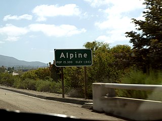
Alpine is a census-designated place (CDP) in the Cuyamaca Mountains of San Diego County, California. Alpine had a population of 14,696 at the 2020 census, up from 14,236 at the 2010 census. The town is largely surrounded by the Cleveland National Forest and borders two reservations of the Kumeyaay Nation, Viejas and Sycuan, and the rural unincorporated areas around the city of El Cajon.

The Kumeyaay, also known as 'Iipai-Tiipai or by the historical Spanish name Diegueño, is a tribe of Indigenous peoples of the Americas who live at the northern border of Baja California in Mexico and the southern border of California in the United States. They are an indigenous people of California.
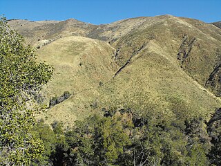
The Laguna Mountains are a mountain range of the Peninsular Ranges System in eastern San Diego County, southern California. The mountains run in a northwest/southeast alignment for approximately 35 miles (56 km).

Palomar Mountain is a mountain ridge in the Peninsular Ranges in northern San Diego County. It is famous as the location of the Palomar Observatory and Hale Telescope, and known for the Palomar Mountain State Park.
Tecate is a city in Tecate Municipality, Baja California. It is across the Mexico–US border from Tecate, California. As of 2019, the city had a population of 108,860 inhabitants, while the metropolitan area has a population of 132,406 inhabitants. Tecate is part of the San Diego-Tijuana metropolitan area and the largest city between Tijuana and Mexicali. Tecate is a regional economic hub and popular tourist destination, known as home to the Tecate Port of Entry and to Tecate Beer.

Boulevard is a census-designated place (CDP) in the Mountain Empire area of southeastern San Diego County, California. At that time, it had a population of 359 at the 2020 United States census, up from 315 2010 United States census. The area is rural high desert along the Mexican border near the eastern extent of San Diego County.

Campo is an unincorporated community in the Mountain Empire area of southeastern San Diego County, California, United States. The population was 2,955 at the 2020 United States census, up from 2,684 at the 2010 census. For statistical purposes, the United States Census Bureau has defined Campo as a census-designated place (CDP). The census definition of the area may not precisely correspond to local understanding of the area with the same name.

The Campo Indian Reservation is home to the Campo Band of Diegueño Mission Indians, also known as the Campo Kumeyaay Nation, a federally recognized tribe of Kumeyaay people in the southern Laguna Mountains, in eastern San Diego County, California. The reservation was founded in 1893 and is 16,512 acres (66.82 km2).

Santiago Peak is the southern mountain of the Saddleback landform in Orange County, California. It is the highest and most prominent peak of both the Santa Ana Mountains and Orange County; it also marks a border point with Riverside County. The peak is named for Santiago Creek, which begins on its southwestern slope. During most winters, snow falls at least once on the peak. A telecommunication antenna farm with microwave antennas sits atop the peak.
Guatay is an unincorporated community in the Cuyamaca Mountains, in the Mountain Empire area of southeastern San Diego County, California.

Coyote Mountain is a mountain of the Santa Rosa Mountains range, in eastern San Diego County, California.

The San Ysidro Mountains are a mountain range in southern San Diego County, California and Baja California, Mexico. The mountains are a rugged coastal foothill range of the Peninsular Ranges system. Major peaks include the highest summit of the range, Otay Mountain, and the Cerro San Isidro which forms the southern extrusion of the range on the Mexican side of the border. The majority of the range is within the Otay Mountain Wilderness Area, in the United States.

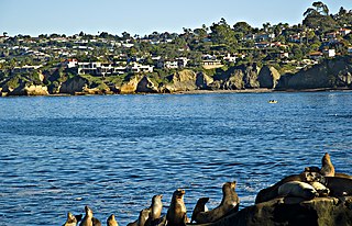
San Diego County, officially the County of San Diego, is a county in the southwestern corner of the U.S. state of California. As of the 2020 census, the population was 3,298,634, making it California's second-most populous county and the fifth-most populous in the United States. Its county seat is San Diego, the second-most populous city in California and the eighth-most populous city in the United States. It is the southwesternmost county in the 48 contiguous United States, and is a border county. It is also home to 18 Native American tribal reservations, the most of any county in the United States.

Viejas Mountain is a mountain in San Diego County in the U.S. state of California. At 4,189 feet (1,277 m), Viejas Mountain is the 48th tallest peak in San Diego County. The mountain can be seen from parts of metropolitan San Diego. The summit is about 3 miles (5 km) northeast of the community of Alpine in the Cleveland National Forest.

El Vallecito is an archaeological site located in the city of La Rumorosa, in the Tecate Municipality, Baja California, Mexico.
Cottonwood Creek is a major stream, about 36 miles (58 km) long, in southern San Diego County, California. It is part of the Tijuana River drainage basin.
Crestwood Summit is a highway pass through the Cuyamaca Mountains of southeastern San Diego County, California, traversed by Interstate 8. Its elevation is 4,190 feet (1,280 m) westbound, and 4,181 feet (1,274 m) eastbound. It is the highest point on Interstate 8.

Woodson Mountain, or widely known as Mount Woodson is a mountain near Poway, California and is known for Potato Chip Rock which located to the west of the summit.