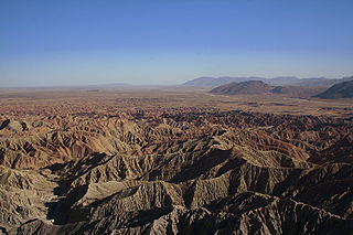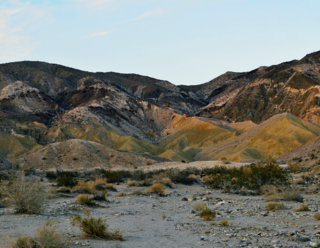
Anza-Borrego Desert State Park is a California State Park located within the Colorado Desert of Southern California, United States. The park takes its name from 18th century Spanish explorer Juan Bautista de Anza and borrego, a Spanish word for sheep. With 585,930 acres (237,120 ha) that includes one-fifth of San Diego County, it is the largest state park in California and the third largest state park nationally.

The Santa Rosa Mountains are a short mountain range in the Peninsular Ranges system, located east of the Los Angeles Basin and northeast of the San Diego metropolitan area of southern California, in the southwestern United States.

Equus scotti is an extinct species of horse native to Pleistocene North America.
The Carrizo Impact Area was used by the United States Navy as an air-to-ground bombing range during World War II and the Korean War. It is in the Anza-Borrego Desert in south central California and covers about 45 square miles (120 km2). The majority of the range is in Anza-Borrego Desert State Park and about a third is owned by the United States Bureau of Land Management, including the Fish Creek Mountains Wilderness. The Navy currently only owns about 2 percent of the land and about 5 percent is privately owned. There are no structures or habitations within a 20-mile (32 km) radius of the site.

The Coyote Mountains are a small mountain range in San Diego and Imperial Counties in southern California. The Coyotes form a narrow ESE trending 2 mi (3.2 km) wide range with a length of about 12 mi (19 km). The southeast end turns and forms a 2 mi (3.2 km) north trending "hook". The highest point is Carrizo Mountain on the northeast end with an elevation of 2,408 feet (734 m). Mine Peak at the northwest end of the range has an elevation of 1,850 ft (560 m). Coyote Wash along I-8 along the southeast margin of the range is 100 to 300 feet in elevation. Plaster City lies in the Yuha Desert about 5.5 mi (8.9 km) east of the east end of the range.
Banner is an unincorporated community in San Diego County, California. It lies at an elevation of 2743 feet. It is located on California State Route 78.

Palm Spring is a spring in Mesquite Oasis, a desert oasis amidst a mesquite thicket and a few palms, close to Carrizo Creek, within the Anza-Borrego Desert State Park in San Diego County, California.
Carrizo Creek Station is a former stage station of the San Antonio-San Diego Mail Line and Butterfield Overland Mail, located in Imperial County, California, just east of the San Diego County line. It lies within the boundaries of the Anza-Borrego Desert State Park just west of the Carrizo Impact Area. Its site is located along the bank of Carrizo Creek.

The Carrizo Badlands are a landform of badlands that lie within Anza-Borrego Desert State Park in eastern San Diego County, and in the Carrizo Impact Area in western Imperial County, in Southern California.
The Carrizo Creek and Carrizo Wash in California are a stream and an arroyo in San Diego County, California, and Imperial County, California.
San Felipe Creek is a stream in Imperial and San Diego Counties of California. It arises in the Volcan Mountains of San Diego County 33°11′57″N116°37′35″W, and runs eastward, gathering the waters of most of the eastern slope of the mountains and desert of the county in the San Sebastian Marsh before it empties into the Salton Sea. It is probably the last remaining perennial natural desert stream in the Colorado Desert region. In 1974, the San Felipe Creek Area was designated as a National Natural Landmark by the National Park Service.

Carrizo Gorge is a valley in the Jacumba Mountains in San Diego County, California. Its mouth is at an elevation of 1,411 feet (430 m), where it widens out to become Carrizo Canyon, 1 mi (1.6 km) northeast of Palm Grove. Its head is located in the Jacumba Mountains, 1.5 mi (2.4 km) north of Round Mountain, at an elevation of 2,600 ft (790 m) at 32°39′38″N116°11′28″W.
Carrizo Valley is a valley between the Vallecito Mountains and Carrizo Badlands to the north and the Tierra Blanca Mountains, Jacumba Mountains and Coyote Mountains on the south, in San Diego County, California. Its mouth is at an elevation or 623 feet / 190 meters. Its source is at an elevation of 1,315 feet at 32°58′07″N116°18′37″W at the mouth of the narrow Carrizo Canyon where Vallecito Creek passes between the Tierra Blanca Mountains and Vallecito Mountains.

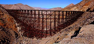
Goat Canyon Trestle is a wooden trestle in San Diego County, California. At a length of 597–750 feet (182–229 m), it is the world's largest all-wood trestle. Goat Canyon Trestle was built in 1933 as part of the San Diego and Arizona Eastern Railway, after one of the many tunnels through the Carrizo Gorge collapsed. The railway had been called the "impossible railroad" upon its 1919 completion. It ran through Baja California and eastern San Diego County before ending in Imperial Valley. The trestle was made of wood, rather than metal, due to temperature fluctuations in the Carrizo Gorge. By 2008, most rail traffic stopped using the trestle.

Galleta Meadows Estate is privately owned desert estate land that consists of many separate plots in Borrego Springs, California and that features over 130 large metal art sculptures. The sculptures were created by Southern California artist Ricardo Breceda via commission from Dennis Avery, the owner of Galleta Meadows. Now deceased and an heir to the Avery label fortune, Mr. Avery located the sculptures on land he purchased for conservation.
Borrego Valley Groundwater Basin, located in the very southern region of California, is one of the driest basins in the state. With climate change predicted to have strong effects into foreseeable future, the region is viewed with a skepticism in the sustainable use of water at current rates of consumption. Both natural and man-made geographic divisions within this basin allow for a closer inspection of the various management techniques implemented throughout the years, and provide a basis for what may be pursued for an uncertain future.

Goat Canyon is a valley in San Diego County, California, United States, located within the Carrizo Gorge in the Jacumba Mountains. The rock forming the canyon is crystalline basement. One feature of the canyon is a dry waterfall. The canyon is bridged by a wooden railroad trestle, the Goat Canyon Trestle, which is the world's largest curved all-wood trestle. The canyon is accessible by trail by traveling west from Mortero Palms.

Borrego Valley Maneuver Area also called the Borrego Springs Naval Maneuver Area was a US Army Anti-Aircraft Training Center (AARTC) and a subcamp of Camp Callan. Located near Borrego Springs, California in San Diego County in the Imperial Valley. Opened in March 1942 and in use until August 1944, it was operated by the Western Defense Command. Marine Corps also used the site to train troops in driving army vehicles. The site was picked as it was 400 square miles, 255,840 acres, of barren desert, barren mountains, and badlands. When closed the land returned to the State of California. Built at the site were bombing stations, strafing stations, and rocket targets. Also installed was Anti-Aircraft Artillery for training. First week troop did dry run training and the second week live-fire training. Ammo fired was from .33cal to 90mm. The US Navy trained in the bombing, gunnery, and rocketry ranges. California Institute of Technology help with the rocket training. The air support for the base was Naval Outlying Landing Field Clark's Dry Lake, Naval Outlying Field, Ocotillo Dry Lake and Borrego Hotel Naval Outlying Landing Field.
Canebrake Canyon is a valley at an elevation of 1145 feet in the deserts of Southern California. Canebrake Canyon is found southwest of Mesquite Oasis, northeast of the Tierra Blanca Mountains. An open wilderness of San Diego County, California, it is reached nearby from popular Anza-Borrego Desert State Park and is a remote hiking destination.

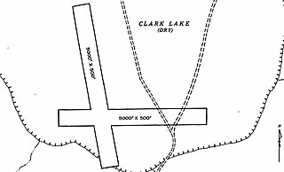
Naval Outlying Field Clark's Dry Lake was a United States Navy facility built for World War 2. The site had two runways and a bombing range for training. The base was a subcamp of NAS San Diego. The site was built in 1938 and closed in 1962, but not used continuously. The range is in the Anza-Borrego Desert, west of Salton Sea, north of Borrego Springs, California. The Field Clark's Dry Lake was supported and used by Naval Auxiliary Air Station Salton Sea 27 miles away. The airfield was on the western side of Clark's Dry Lake. The airfield was mostly used as an Emergency Landing strip. The bombing target range was northeast of the runways. When in use the ground staff had a radio communication station to talk the aircraft. In addition to bombing training, the base had gunnery and rocketry targets for training. The main runway was 7,500-feet, the other 5,000-feet, and both not usable when wet.


