Related Research Articles

Jornada del Muerto was the name given by the Spanish conquistadors to the Jornada del Muerto desert basin, and the almost waterless 90-mile (140 km) trail across the Jornada beginning north of Las Cruces and ending south of Socorro, New Mexico. The name translates from Spanish as "Dead Man's Journey" or "Route of the Dead Man". The trail was part of the Camino Real de Tierra Adentro which led northward from central colonial New Spain, present-day Mexico, to the farthest reaches of the viceroyalty in northern Nuevo México Province.

The Salton Sea is a shallow, landlocked, highly saline endorheic lake in Riverside and Imperial counties at the southern end of the U.S. state of California. It lies on the San Andreas Fault within the Salton Trough, which stretches to the Gulf of California in Mexico.

The Imperial Valley of Southern California lies in Imperial and Riverside counties, with an urban area centered on the city of El Centro. The Valley is bordered by the Colorado River to the east and, in part, the Salton Sea to the west. Farther west lies the San Diego and Imperial County border. To the north is the Coachella Valley region of Riverside County, which together with Imperial Valley form the Salton Trough, or the Cahuilla Basin, also the county line of Imperial and Riverside counties, and to the south the international boundary with Mexico.

The Mojave Road, also known as Old Government Road, is a historic route and present day dirt road across what is now the Mojave National Preserve in the Mojave Desert in the United States. This rough road stretched 147 miles (237 km) from Beale's Crossing, to Fork of the Road location along the north bank of the Mojave River where the old Mojave Road split off from the route of the Old Spanish Trail/Mormon Road.
Sackett's Wells is a former settlement in Imperial County, California. It was located 3 miles (4.8 km) west northwest of Plaster City, in or near Coyote Wash.

The Sonny Bono Salton Sea National Wildlife Refuge is located in the Imperial Valley of California, 40 miles (64 km) north of the Mexican border. Situated at the southern end of the Salton Sea, the refuge protects one of the most important nesting sites and stopovers along the Pacific Flyway. Despite its location in the Colorado Desert, a subdivision of the larger Sonoran Desert, the refuge contains marine, freshwater, wetland, and agricultural habitats which provide sanctuary for hundreds of birds and wetland species, including several that have been listed as endangered or sensitive by the U.S. Fish and Wildlife Service.
In the history of the American frontier, pioneers built overland trails throughout the 19th century, especially between 1840 and 1847 as an alternative to sea and railroad transport. These immigrants began to settle much of North America west of the Great Plains as part of the mass overland migrations of the mid-19th century. Settlers emigrating from the eastern United States did so with various motives, among them religious persecution and economic incentives, to move from their homes to destinations further west via routes such as the Oregon, California, and Mormon Trails. After the end of the Mexican–American War in 1849, vast new American conquests again encouraged mass immigration. Legislation like the Donation Land Claim Act and significant events like the California Gold Rush further encouraged settlers to travel overland to the west.

The Alamo Canal was a 14 mi (23 km) long waterway that connected the Colorado River to the head of the Alamo River. The canal was constructed to provide irrigation to the Imperial Valley. A small portion of the canal was located in the United States but the majority of the canal was located in Mexico. The Alamo Canal is also known as the Imperial Canal.
The Butterfield Overland Mail in California was created by the United States Congress on March 3, 1857, and operated until June 30, 1861. Subsequently, other stage lines operated along the Butterfield Overland Mail in route in Alta California until the Southern Pacific Railroad arrived in Yuma, Arizona in 1877.

Southern Emigrant Trail, also known as the Gila Trail, the Kearny Trail, Southern Trail and the Butterfield Stage Trail, was a major land route for immigration into California from the eastern United States that followed the Santa Fe Trail to New Mexico during the California Gold Rush. Unlike the more northern routes, pioneer wagons could travel year round, mountain passes not being blocked by snows; however, it had the disadvantage of summer heat and lack of water in the desert regions through which it passed in New Mexico Territory and the Colorado Desert of California. Subsequently, it was a route of travel and commerce between the eastern United States and California. Many herds of cattle and sheep were driven along this route and it was followed by the San Antonio-San Diego Mail Line in 1857–1858 and then the Butterfield Overland Mail from 1858 to 1861.
Alamo Mucho Station, the misspelled name of Alamo Mocho Station was one of the original Butterfield Overland Mail stations located south of the Mexican border, in Baja California. Its location is 0.5 miles south-southeast of the Mexicali International Airport Terminal building.
Cooke's Wells Station a stage station of the Butterfeild Overland Mail, located south of the Mexican border, in the old Alamos River bed, about 1 km west northwest of Mérida, Baja California. Its site was at Cooke's Wells, named for Philip St. George Cooke whose expedition found them in 1847. It was at first the only water source 22 miles (35 km) east of Alamo Mucho Station and 18 miles (29 km) west of the Pilot Knob Station on the Southern Emigrant Trail.
The Butterfield Overland Mail route in Baja California was created as a result of an act by the United States Congress on March 3, 1857, and operated until June 30, 1861 as part of the Second Division of the route. Subsequently other stage lines operated along the route until the Southern Pacific Railroad arrived in Yuma, Arizona.
New River Station was a later station added into the Colorado Desert route of the Butterfield Overland Mail it was located 15 miles southeast of Indian Wells Station and 14 miles west of Alamo Mocho Station beside the New River. It was in operation until March 1861 when the Butterfield route was abandoned for the Central Route by the beginning of the American Civil War.
Gardener's Wells Station was built at the site of Gardener's Wells in Baja California was one of the wells developed by the Butterfield Overland Mail, as a part of its improvements of its Colorado Desert route between Cooke's Wells Station and Alamo Mocho Station. These wells allowed travel along the level ground along the 19th century course of the Alamo River, avoiding the more difficult route up on Andrade Mesa.
Seven Wells Station was built at the site, of Salt or Seven Wells one of the wells developed by the Butterfield Overland Mail, as a part of its improvements of its Colorado Desert route between Cooke's Wells Station and Alamo Mocho Station. These wells allowed travel along the level ground along the 19th century course of the Alamo River, avoiding the more difficult route up on Andrade Mesa.
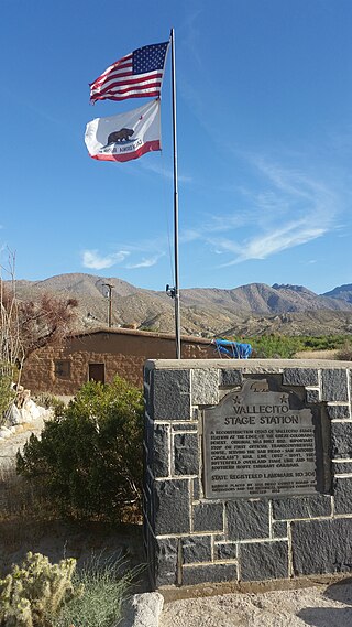
Vallecito, in San Diego County, California, is an oasis of cienegas and salt grass along Vallecito Creek and a former Kumeyaay settlement on the edge of the Colorado Desert in the Vallecito Valley. Its Spanish name is translated as "little valley". Vallecito was located at the apex of the gap in the Carrizo Badlands created by Carrizo Creek and its wash in its lower reach, to which Vallecito Creek is a tributary. The springs of Vallecito, like many in the vicinity, are a product of the faults that run along the base of the Peninsular Ranges to the west.
The Carrizo Creek and Carrizo Wash in California are a stream and an arroyo that the stream flows into, in San Diego County, California, and Imperial County, California.
Cooke's Wagon Road or Cooke's Road was the first wagon road between the Rio Grande and the Colorado River to San Diego, through the Mexican provinces of Nuevo México, Chihuahua, Sonora and Alta California, established by Philip St. George Cooke and the Mormon Battalion, from October 19, 1846 to January 29, 1847 during the Mexican–American War. It became the first of the wagon routes between New Mexico and California that with subsequent modifications before and during the California Gold Rush eventually became known as the Southern Trail or Southern Emigrant Trail.

Charles Robinson Rockwood was a United States (U.S.) civil engineer, and entrepreneur. His career was in various states of the United States, particularly in the state of California. His most significant achievement was managing the construction of a canal system that transformed the Colorado Desert (in southern California into a verdant agricultural development known as the Imperial Valley. He is also infamous for directing modifications to that same canal system which led to the accidental creation of the Salton Sea in southern California.
References
- 1 2 3 4 5 Durham, David L. (1998). California's Geographic Names: A Gazetteer of Historic and Modern Names of the State. Clovis, Calif.: Word Dancer Press. p. 1466. ISBN 1-884995-14-4.
- ↑ Reports of explorations and surveys: to ascertain the most practicable and economical route for a railroad from the Mississippi River to the Pacific Ocean, Volume 7, By United States. War Dept, Joseph Henry, Spencer Fullerton Baird, United States. Army. Corps of Engineers, A.O.P. Nicholson, Printer, Washington D.C., 1857, p.23
- ↑ Tom Jonas, Wells in the Desert, Retracing the Mexican War Trails of Kearny and Cooke through Baja California, The Journal of Arizona History, Vol. 50, No. 3, Autumn 2009 Archived 2013-10-16 at the Wayback Machine , p. 292 and note 40
