Juan Bautista de Anza Bezerra Nieto was an expeditionary leader, military officer, and politician primarily in California and New Mexico under the Spanish Empire. He is credited as one of the founding fathers of Spanish California and served as an official within New Spain as Governor of the Province of New Mexico.

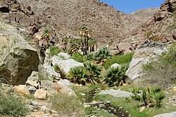
Anza-Borrego Desert State Park is a California State Park located within the Colorado Desert of southern California, United States. The park takes its name from 18th century Spanish explorer Juan Bautista de Anza and borrego, a Spanish word for sheep. With 585,930 acres (237,120 ha) that includes one-fifth of San Diego County, it is the largest state park in California and the second biggest park nationally.

The Coyote Mountains are a small mountain range in San Diego and Imperial Counties in southern California. The Coyotes form a narrow ESE trending 2 mi (3.2 km) wide range with a length of about 12 mi (19 km). The southeast end turns and forms a 2 mi (3.2 km) north trending "hook". The highest point is Carrizo Mountain on the northeast end with an elevation of 2,408 feet (734 m). Mine Peak at the northwest end of the range has an elevation of 1,850 ft (560 m). Coyote Wash along I-8 along the southeast margin of the range is 100 to 300 feet in elevation. Plaster City lies in the Yuha Desert about 5.5 mi (8.9 km) east of the east end of the range.

The Santa Rosa Wilderness is a 72,259-acre (292.42 km2) wilderness area in Southern California, in the Santa Rosa Mountains of Riverside and San Diego counties, California. It is in the Colorado Desert section of the Sonoran Desert, above the Coachella Valley and Lower Colorado River Valley regions in a Peninsular Range, between La Quinta to the north and Anza Borrego Desert State Park to the south. The United States Congress established the wilderness in 1984 with the passage of the California Wilderness Act, managed by both the US Forest Service and the Bureau of Land Management. In 2009, the Omnibus Public Land Management Act was signed into law which added more than 2,000 acres (8.1 km2). Most of the Santa Rosa Wilderness is within the Santa Rosa and San Jacinto Mountains National Monument.
The Butterfield Overland Mail in California was created by the United States Congress on March 3, 1857, and operated until June 30, 1861. Subsequently, other stage lines operated along the Butterfield Overland Mail in route in Alta California until the Southern Pacific Railroad arrived in Yuma, Arizona in 1877.
Sunbelt Publications is an American publication company that was incorporated in 1988. The company publishes and distributes multi-language pictorials, natural science and outdoor guidebooks, and regional references. The company is located in El Cajon, California.

Vallecito, in San Diego County, California, is an oasis of cienegas and salt grass along Vallecito Creek and a former Kumeyaay settlement on the edge of the Colorado Desert in the Vallecito Valley. Its Spanish name is translated as "little valley". Vallecito was located at the apex of the gap in the Carrizo Badlands created by Carrizo Creek and its wash in its lower reach, to which Vallecito Creek is a tributary. The springs of Vallecito, like many in the vicinity, are a product of the faults that run along the base of the Peninsular Ranges to the west.
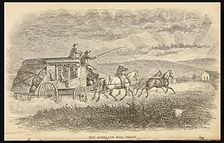
Palm Spring Station is a former Butterfield Overland Mail stagecoach station located at Palm Spring in San Diego County, California. This station built in 1858 by division agent, Warren F. Hall is commemorated by California State Historical Marker Number 639 Palm Spring.
Carrizo Creek Station, a former stage station of the San Antonio-San Diego Mail Line and Butterfield Overland Mail, located in Imperial County, California just east of the San Diego County line. It lies within the boundaries of the Anza-Borrego Desert State Park just west of the Carrizo Impact Area. Its site is located along the bank of Carrizo Creek.
San Felipe Creek is a stream in Imperial and San Diego Counties of California. It arises in the Volcan Mountains of San Diego County 33°11′57″N116°37′35″W, and runs eastward, gathering the waters of most of the eastern slope of the mountains and desert of the county in the San Sebastian Marsh before it empties into the Salton Sea. It is probably the last remaining perennial natural desert stream in the Colorado Desert region. In 1974, the San Felipe Creek Area was designated as a National Natural Landmark by the National Park Service.
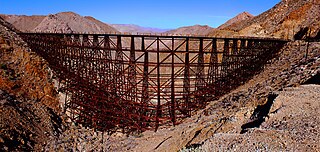
Goat Canyon Trestle is a wooden trestle in San Diego County, California. At a length of 597–750 feet (182–229 m), it is the world's largest all-wood trestle. Goat Canyon Trestle was built in 1933 as part of the San Diego and Arizona Eastern Railway, after one of the many tunnels through the Carrizo Gorge collapsed. The railway had been called the "impossible railroad" upon its 1919 completion. It ran through Baja California and eastern San Diego County before ending in Imperial Valley. The trestle was made of wood, rather than metal, due to temperature fluctuations in the Carrizo Gorge. By 2008, most rail traffic stopped using the trestle.
Goat Canyon is a valley in San Diego County, California, United States, located within the Carrizo Gorge in the Jacumba Mountains. The rock forming the canyon is crystalline basement. One feature of the canyon is a dry waterfall. The canyon is bridged by a wooden railroad trestle, the Goat Canyon Trestle, which is the world's largest curved all-wood trestle. The canyon is accessible by trail by traveling west from Mortero Palms.
Canebrake Canyon is a valley at an elevation of 1145 feet in the deserts of Southern California. Canebrake Canyon is found southwest of Mesquite Oasis, northeast of the Tierra Blanca Mountains. An open wilderness of San Diego County, California, it is reached nearby from popular Anza-Borrego Desert State Park and is a remote hiking destination.
Yaqui Well is a historic spring located in Anza-Borrego Desert State Park in southeastern San Diego County, California in the United States about 21.4 mi (34.4 km) east of Warner Springs. The watering hole can be reached by a popular 1.64 mi (2.64 km) one-hour hiking trail starting at Tamarisk Grove Campground. The trail was described in the New York Times as a "flat, gentle hike—the kind that wraps around small, sloping hills, abuts a shallow canyon, and rewards its guests with an otherworldly view of the desert at the finale."

San Gregorio campsite at the Borrego Sink in the Borrego Valley, Borrego Springs, California in San Diego County, is a California Historical Landmark No. 673 listed on February 16, 1959. The San Gregorio campsite was a desert camp for the Spanish Commander Juan Bautista de Anza expedition of 1775 and 1776. The expedition passed though the Imperial Valley then though the Colorado Desert, now the Anza-Borrego Desert State Park. The expedition's goal was to start Spanish missions in California and presidio forts though Las Californias to the San Francisco Bay. The expedition route is now the Juan Bautista de Anza National Historic Trail.
Box Canyon in Anza-Borrego Desert State Park in San Diego County, is a California Historical Landmark No. 472 listed on September 11, 1950. Box Canyon is a desert canyon and mountain pass on the Historic Southern Emigrant Trail. The US troops under General Stephen Watts Kearny and with US scout Kit Carson found Box Canyon and its pass in October 1846. On January 19, 1847, Kearny was the leader of a wagon train with Colonel Philip St. George Cooke and the Mormon Battalion that used Box Canyon to head west. The group used hand tool to widen and clear Box Canyon so the covered wagons could pass. The road through Box Canyon became the first road into Southern Alta California.

El Vado campsite in the Borrego Valley, Borrego Springs, California in San Diego County, is a California Historical Landmark No. 634 listed on March 3, 1958. The El Vado campsite was a desert camp for the Spanish Commander Juan Bautista de Anza and Father Francisco Garcés expedition of 1775 and 1776. The expedition camped for three days and two nights from December 20 to 22, 1775. At the campsite the expedition rested and watered its stock of mules, cattle, and horses.

La Cristianita Canyon, or La Christianita Canyon, Los Cristianitos Valley, Canyon of the Little Christians, La Cañada de los Bautismos is a canyon now on the Marine Corps Base Camp Pendleton in San Clemente, San Diego County. La Cristianita Canyon is a California Historical Landmark No. 562 listed on December 31, 1956. The site was a campsite for the Spanish Commander Juan Bautista de Anza and Father Francisco Garcés expedition of 1775 and 1776. The expedition camped at the site in July 1769. At the campsite was a spring where the expedition rested and watered its stock of mules, cattle, and horses.

Los Puertecitos Pass in Ocotillo Wells, California in San Diego County, is California Historical Landmark No. 635 listed on March 3, 1958. The Los Puertecitos is a desert pass used by the Spanish Commander Juan Bautista de Anza and Father Francisco Garcés expedition of 1775 and 1776. The expedition came through the pass on December 19, 1775. Near the pass on a flats east of the pass the expedition rested and watered its stock of mules, cattle, and horses.

Santa Catarina campsite in the Borrego Valley, Borrego Springs, California in San Diego County, is a California Historical Landmark No. 785 listed on March 3, 1958. The Santa Catarina campsite was a desert camp for the Spanish Commander Juan Bautista de Anza and Father Francisco Garcés expedition of 1775 and 1776. At the campsite the expedition rested and watered its stock of mules, cattle, and horses on March 14, 1774.