Felicity, California

Last updated

Felicity, California
USA California location map.svg
Red pog.svg
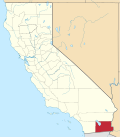
Felicity, California
Location in California
Usa edcp location map.svg
Red pog.svg
Felicity, California
Felicity, California (the United States)
Coordinates: 32°45′01″N114°45′55″W / 32.75028°N 114.76528°W / 32.75028; -114.76528
Country United States
State California
County Imperial County
Elevation
[1]
285 ft (87 m)

Felicity is an unincorporated community in Imperial County, California. [1] [2] The town was established in 1986 by Jacques-Andre Istel who bought the land in the 1950s and developed it in the 1980s after selling off his parachute business. The town is "Dedicated to Remembrance" and named for Istel's wife Felicia. [3] It is 2,600 acres and lies at an elevation of 285 feet (87 m). [1]

It is accessible from Interstate 8 in the far southeast of the state, just west of Yuma, Arizona. [4]

The Quechan Tribe of the Fort Yuma Indian Reservation is located nearby. During World War II, the town was the site of Camp Pilot Knob, the US Army's training center. [5]

The town's key features are a 21-foot-tall stone-and-glass pyramid (6.4 m), a church on a man-made hill, and the Museum of History in Granite, which Istel has been developing since the town's founding. The museum consists of dozens of granite panels, most of them over 100 feet long and weighing approximately 500 tons. Etched on the panels is a historical record of humanity as chronicled by Istel. The lead artist on the project is Gene Britton. [3]

In May 1985, the Imperial County Board of Supervisors designated Felicity as the Official Center of the World. [2] [4]

Related Research Articles

<span class="mw-page-title-main">Imperial County, California</span> County in California, United States

Imperial County is a county located on the southeast border of the U.S. state of California. As of the 2020 census, the population was 179,702, making it the least populous county in Southern California. The county seat and largest city is El Centro. Imperial is the most recent California county to be established, as it was created in 1907 out of portions of San Diego County.

<span class="mw-page-title-main">Winterhaven, California</span> Census-designated place in California, United States

Winterhaven is a census-designated place (CDP) in Imperial County, California. Winterhaven is 6.5 miles (10 km) east of Pilot Knob, The population was 394 at the 2010 census, down from 529 at the 2000 census. It is part of the El Centro, CA Metropolitan Area. North of Interstate 8 and bordering Yuma, Arizona, the town is partly in the Fort Yuma Indian Reservation. The Colorado River marks the town's southern border.

<span class="mw-page-title-main">Ventifact</span> Rock that has been eroded by wind-driven sand or ice crystals

A ventifact is a rock that has been abraded, pitted, etched, grooved, or polished by wind-driven sand or ice crystals. These geomorphic features are most typically found in arid environments where there is little vegetation to interfere with aeolian particle transport, where there are frequently strong winds, and where there is a steady but not overwhelming supply of sand.

<span class="mw-page-title-main">San Diego-Imperial Council</span>

The San Diego-Imperial Council is headquartered in San Diego, California, and serves youth members and volunteer leaders through Scout units in San Diego and Imperial counties of Southern California, as well as a portion of Arizona.

<span class="mw-page-title-main">General George S. Patton Memorial Museum</span> Biographical museum in Chiriaco Summit, California /

The General George S. Patton Memorial Museum, in Chiriaco Summit, California, is a museum erected in tribute to General George S. Patton on the site of the entrance of Camp Young, part of the Desert Training Center of World War II.

Jacques-André Istel is a French-American recreational parachutist and investment banker and later in life, historian, widely responsible for popularizing parachuting in the United States. He is considered "the father of American skydiving." He founded a city in southeastern California, which he named Felicity and it is here that he founded the Museum of History in Granite.

Andrade is a small locale in the southeasternmost corner of the state of California, in Imperial County. The community is located entirely within the Fort Yuma Indian Reservation. It is directly across the border from Los Algodones, the northernmost town of the municipality of Mexicali, in Baja California, and in all of Mexico. The ZIP Code is 92283. The community is inside area codes 442 and 760.

<span class="mw-page-title-main">Pilot Knob (Imperial County, California)</span> Volcanic plug in Imperial County, California, United States

Pilot Knob is a peak in Imperial County, California. Pilot Knob is located 8 miles (13 km) southeast of Ogilby, It rises to an elevation of 876 feet (267 m). Pilot Knob is a rocky landform, geologically a Volcanic plug, west of Yuma, Arizona–Winterhaven, California; it is connected to the Cargo Muchacho Mountains, the central portion of the mountains being about 7 miles (11 km) north. Pilot Knob was named for its prominence as a landmark for riverboat traffic in the 19th-20th centuries on the Colorado River which borders Winterhaven–Yuma. Pilot Knob is an Area of Critical Environmental Concern administered by the Bureau of Land Management.

<span class="mw-page-title-main">Desert Training Center</span> US Army training centers during World War II

The Desert Training Center (DTC), also known as California–Arizona Maneuver Area (CAMA), was a World War II training facility established in the Mojave Desert and Sonoran Desert, largely in Southern California and Western Arizona in 1942.

<span class="mw-page-title-main">Museum of History in Granite</span> Museum in Granite, California

The Museum of History in Granite is a museum in the town of Felicity, California. The museum exhibits monuments made from Missouri Red Granite. Each is 100 feet (30 m) long. Conceived as a historic record of humanity designed to last for four millennia, the Museum of History in Granite is a collection of over 900 large granite outdoor panels. The museum was conceived and commissioned by Jacques-André Istel and its lead artist is Gene Britton.

<span class="mw-page-title-main">Camp Granite</span> California Historic Landmark

The Camp Granite was a sub camp of the US Army Desert Training Center in Riverside County, California. The main headquarters for the Desert Training Center was Camp Young were General Patton's 3rd Armored Division was stationed. Camp Granite was designated a California Historic Landmark (No.985.2). The site of the Camp Granite is 45 miles East of Indio, California off Interstate 10 and California State Route 62 near the Granite Mountains.

<span class="mw-page-title-main">Camp Coxcomb</span> California Historic Landmark

The Camp Coxcomb was a sub camp of the US Army Desert Training Center in Riverside County, California. The main headquarters for the Desert Training Center was Camp Young where General Patton's 3rd Armored Division was stationed. Camp Coxcomb was designated a California Historic Landmark (No.985). The site of the Camp Granite is 45 miles East of Indio, California off Interstate 10 and California State Route 177 near the Coxcomb Mountains. The train stop at Freda railroad siding delivered Troops and equipment. The camp closed in early in 1944 after about two years of operations.

<span class="mw-page-title-main">Camp Clipper</span> Former US Army camp in Mojave Desert, California

The Camp Clipper and Camp Essex were sub camps of the US Army Desert Training Center in San Bernardino County, California, located near Historic Route 66 and the Santa Fe Railway. The main headquarters for the Desert Training Center was Camp Young. This is where General Patton's 3rd Armored Division was stationed. Camp Clipper was designated a California Historic Landmark (No.985.5). The site of Camp Clipper is at the Fenner Rest Area in Fenner, California, on Interstate 40 and Route 66, 32 miles (51 km) west of Needles in San Bernardino County, California, near Clipper Mountains. Currently at the south end of the Mojave National Preserve. Camp Clipper was just to the east of Camp Essex. Clipper was a temporary camp for incoming and out going troops. Camp Essex was named after a small town near the camp, Essex. Near Camp Clipper was the 4,500 foot Camp Essex Army Airfield.

<span class="mw-page-title-main">Camp Iron Mountain</span> California Historic Landmark

The Camp Iron Mountain was a sub camp of the US Army Desert Training Center in Riverside County, California. The main headquarters for the Desert Training Center was Camp Young; this is where General Patton's 3rd Armored Division was stationed. Camp Iron Mountain was designated a California Historic Landmark (No.985.6). Camp Iron Mountain is near the site of Camp Granite, both are 45 miles (72 km) miles East of Indio, California off Interstate 10 and California State Route 62 near the Granite Mountains in San Bernardino County, California. In 1980 Camp Iron Mountain received the listing as an Area of Critical Environmental Concern from the Bureau of Land Management. The listing was given as Camp Iron Mountain is the best preserved of the Desert Training Center Camps. The Bureau of Land Management put up fences to protect the camp from Off-road vehicle traffic. Still at the camp today are a 200 x 175 foot contour training map, some rock mosaics, two church altars, rock lined roads and walkways. The camp is named after the near by Iron Mountains.

<span class="mw-page-title-main">Camp Hyder</span> US Army sub camp during World War II

Camp Hyder was a US Army installation in Arizona, functioning as a subcamp of the Desert Training Center in Riverside County, California. The main headquarters for the Desert Training Center was Camp Young, this is where General Patton's 3rd Armored Division was stationed. Camp Hyder is 2 miles (3.2 km) miles south of Hyder, Arizona. The camp was just north of the Gila River. Camp Hyder is 60 miles (97 km) miles east of Yuma, Arizona, near Camp Horn. Camp Hyder was built at the site of an old 1890s military base. Trained at Camp Hyder, in 1943, for six months was the 77th Infantry Division from April 1943 to September 1943. Then the 104th Infantry Division moved in for training. Unlike the other camps, no large tank activity was done. The camp was built by The 369th Engineer Regiment. Camp Hyder had its own rail station at which most troops arrived. The train station at Sentinel, Arizona south of the camp was also used. Over 13,000 troops were trained at Camp Horn and Camp Hyder.

<span class="mw-page-title-main">Camp Laguna</span> US WWII army training camp

The Camp Laguna was a sub camp of the US Army, Desert Training Center in Riverside County, California. The main headquarters for the Desert Training Center was Camp Young, this is where General Patton's 3rd Armored Division was stationed. Camp Laguna is 16 miles (26 km) miles northeast of Yuma, Arizona, off of U.S. Route 95. Trained at Camp Laguna were the 3rd Armored Divisions the 9th Armored Divisions, the 79th Infantry Divisions, 80th Infantry Divisions and 8th Infantry Division. The camp is named after the nearby town of Laguna, Yuma County, Arizona on the Colorado River. Camp Laguna was first World War II training camp built in the Sonoran Desert of Arizona, it trained thousands of troop for war. Most of the land that was Camp Laguna is now part of the vast Yuma Proving Ground.

<span class="mw-page-title-main">Camp Horn, Arizona</span> California Historic Landmark

The Camp Horn was a sub camp of the US Army, Desert Training Center in Riverside County, California. The main headquarters for the Desert Training Center was Camp Young, this is where General Patton's 3rd Armored Division was stationed. Camp Horn was near Camp Hyder about 6 miles (9.7 km) miles west of Hyder, Arizona. Camp Horn was just north of the Gila River. Camp Horn was 54 miles (87 km) miles east of Yuma, Arizona. Most troop arrived at Camp Horn from the train station at Camp Hyder or the train station at Sentinel, Arizona south of the camp. Over 13,000 troops were trained at Camp Horn and Camp Hyder. The 81st Infantry Division trained at Camp Horn was from June 1943 to November 1943.

<span class="mw-page-title-main">Camp Pilot Knob</span> Historical US Army sub camp in California

The Camp Pilot Knob was a sub camp of the US Army, Desert Training Center in Imperial County, California. The main headquarters for the Desert Training Center was Camp Young, this is where General Patton's 3rd Armored Division was stationed. Camp Pilot Knob was designated a California Historic Landmark (No.985). Camp Pilot Knob is near Felicity, California, in Imperial County, California. Camp Pilot Knob is 2 miles north of the US-Mexico border, just north of the now Interstate 8. The camp is five miles northwest of Yuma, Arizona and 2 miles west of the Colorado river. The camp was built just north of the Felicity train station, which was used to bring the troops and supplies to the camp. The camp is named after a hill south of the camp.

<span class="mw-page-title-main">Camp Seeley</span> US army training center in California

Camp Seeley' was a United States Army World War II training camp near El Centro, California in the Imperial Valley. At Camp Seeley was: the Camp Seeley Combat Firing Range, Camp Seeley Ordnance Desert Proving Ground and Camp Seeley Ordnance Training Center. The 17,574 acres Camp Seeley was 10 miles northwest of the City of El Centro, near the city of Seeley, California. The town is named after Henry Seeley, a pioneer of the Imperial Valley. The camp was north of what is now California State Route 98. The tent camp, in the Yuha Desert, opened November 1940, first based at the camp was the 11th Cavalry Regiment, the troops and Army horse came from the Presidio of Monterey, California. At the camp the 11th Cavalry Regiment took part in desert training and teaching horses to swim across rivers with rider. 11th Cavalry Regiment moved to Camp Lockett at Campo, California in December 1941. The 11th and 28th Cavalry Regiment also trained at the camp, along with the 75th Horse Field Artillery Battalion. In 1942 Camp Seeley was converted to a US Army ordnance proving ground. While the camp is closed the area of Camp Seeley the home of the Historical "The Colonel's Own." 11th Cavalry Horse Honor Guard.

References

  1. 1 2 3 U.S. Geological Survey Geographic Names Information System: Felicity, California
  2. 1 2 Anton, Mike (April 16, 2008). "See it now: the center of the world; The History of Humanity is being etched in stone in the California desert. The real story is the builder". Los Angeles Times . Archived from the original on January 27, 2013. Retrieved January 18, 2021.
  3. 1 2 Mooallem, Jon (February 19, 2014). "A Journey to the Center of the World". The New York Times Magazine . Archived from the original on September 3, 2014. Retrieved January 17, 2021.{{cite news}}: CS1 maint: unfit URL (link)
  4. 1 2 Burke, Anne (2 January 2019). "A strange museum at the 'centre of the world'". BBC. Archived from the original on 6 January 2019.
  5. "Camp Pilot Knob, California". Desert Training Center . Retrieved January 17, 2021.