Related Research Articles

Warner's Ranch, near Warner Springs, California, was notable as a way station for large numbers of emigrants on the Southern Emigrant Trail from 1849 to 1861, as it was a stop on both the Gila River Trail and the Butterfield Overland Mail stagecoach line (1859-1861). It was also operated as a pioneering cattle ranch.
Indian Wells is a former settlement in Imperial County, California. It was located 8 miles (13 km) south-southwest of Seeley.
Sackett's Wells is a former settlement in Imperial County, California. It was located 3 miles (4.8 km) west northwest of Plaster City, in or near Coyote Wash.
The Butterfield Overland Mail in California was created by the United States Congress on March 3, 1857, and operated until June 30, 1861. Subsequently, other stage lines operated along the Butterfield Overland Mail in route in Alta California until the Southern Pacific Railroad arrived in Yuma, Arizona in 1877.

Southern Emigrant Trail, also known as the Gila Trail, the Kearny Trail, Southern Trail and the Butterfield Stage Trail, was a major land route for immigration into California from the eastern United States that followed the Santa Fe Trail to New Mexico during the California Gold Rush. Unlike the more northern routes, pioneer wagons could travel year round, mountain passes not being blocked by snows; however, it had the disadvantage of summer heat and lack of water in the desert regions through which it passed in New Mexico Territory and the Colorado Desert of California. Subsequently, it was a route of travel and commerce between the eastern United States and California. Many herds of cattle and sheep were driven along this route and it was followed by the San Antonio-San Diego Mail Line in 1857–1858 and then the Butterfield Overland Mail from 1858 to 1861.
Alamo Mucho Station, the misspelled name of Alamo Mocho Station was one of the original Butterfield Overland Mail stations located south of the Mexican border, in Baja California. Its location is 0.5 miles south-southeast of the Mexicali International Airport Terminal building.
The San Antonio–San Diego Mail Line, also known as the Jackass Mail, was the earliest overland stagecoach and mail operation from the Eastern United States to California in operation between 1857 and 1861. It was created, organized and financed by James E. Birch the head of the California Stage Company. Birch was awarded the first contract for overland service on the "Southern Route", designated Route 8076. This contract required a semi-monthly service in four-horse coaches, scheduled to leave San Antonio and San Diego on the ninth and the 24th of each month, with 30 days allowed for each trip.
In Texas, the Butterfield Overland Mail service created by Congress on March 3, 1857, was operated until March 30, 1861.
The Butterfield Overland Mail was a transport and mail delivery system that employed stagecoaches that travelled on a specific route between St. Louis, Missouri and San Francisco, California and which passed through the New Mexico Territory. It was created by the United States Congress on March 3, 1857, and operated until March 30, 1861. The route that was operated extended from where the ferry across the Colorado River to Fort Yuma Station, California was located, through New Mexico Territory via, Tucson to the Rio Grande and Mesilla, New Mexico then south to Franklin, Texas, midpoint on the route. The New Mexico Territory mail route was divided into two divisions each under a superintendent. Tucson was the headquarters of the 3rd Division of the Butterfield Overland Mail Company. Franklin Station in the town of Franklin,, was the headquarters of the 4th Division.

Cooke's Wells Station a stage station of the Butterfeild Overland Mail, located south of the Mexican border, in the old Alamos River bed, about 1 km west northwest of Mérida, Baja California. Its site was at Cooke's Wells, named for Philip St. George Cooke whose expedition found them in 1847. It was at first the only water source 22 miles (35 km) east of Alamo Mucho Station and 18 miles (29 km) west of the Pilot Knob Station on the Southern Emigrant Trail.
New River Station was a later station added into the Colorado Desert route of the Butterfield Overland Mail it was located 15 miles southeast of Indian Wells Station and 14 miles west of Alamo Mocho Station beside the New River. It was in operation until March 1861 when the Butterfield route was abandoned for the Central Route by the beginning of the American Civil War.
Gardener's Wells Station was built at the site of Gardener's Wells in Baja California was one of the wells developed by the Butterfield Overland Mail, as a part of its improvements of its Colorado Desert route between Cooke's Wells Station and Alamo Mocho Station. These wells allowed travel along the level ground along the 19th century course of the Alamo River, avoiding the more difficult route up on Andrade Mesa.
Seven Wells Station was built at the site, of Salt or Seven Wells one of the wells developed by the Butterfield Overland Mail, as a part of its improvements of its Colorado Desert route between Cooke's Wells Station and Alamo Mocho Station. These wells allowed travel along the level ground along the 19th century course of the Alamo River, avoiding the more difficult route up on Andrade Mesa.

Vallecito, in San Diego County, California, is an oasis of cienegas and salt grass along Vallecito Creek and a former settlement on the edge of the Colorado Desert in the Vallecito Valley. Its Spanish name is translated as "little valley". Vallecito was located at the apex of the gap in the Carrizo Badlands created by Carrizo Creek and its wash in its lower reach, to which Vallecito Creek is a tributary. The springs of Vallecito, like many in the vicinity, are a product of the faults that run along the base of the Peninsular Ranges to the west.
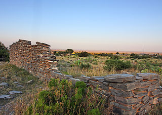
Carrizo Creek Station, a former stage station of the San Antonio-San Diego Mail Line and Butterfield Overland Mail, located in Imperial County, California just east of the San Diego County line. It lies within the boundaries of the Anza-Borrego Desert State Park just west of the Carrizo Impact Area. Its site is located along the bank of Carrizo Creek.
Teofulio Summit, formerly Warner Pass, a pass that lies at an elevation of 3681 feet in the San Felipe Hills of the Peninsular Ranges of San Diego County, California. This pass was named for Teofulio Helm (1874-1967), a prominent member of the Cupeno Band of Mission Indians, who homesteaded in the area.
Hualapai Smith's or Smith's Ferry was a steamboat landing and a ferry crossing and farm on the Sonora bank of the Colorado River, the border between Sonora and Baja California, from the later 1860s to 1878. It was located on the Colorado River in Sonora 20 miles overland from Yuma, Arizona and 30 miles down river from Fort Yuma in 1861.
Cooke's Wagon Road or Cooke's Road was the first wagon road between the Rio Grande and the Colorado River to San Diego, through the Mexican provinces of Nuevo México, Chihuahua, Sonora and Alta California, established by Philip St. George Cooke and the Mormon Battalion, from October 19, 1846 to January 29, 1847 during the Mexican–American War. It became the first of the wagon routes between New Mexico and California that with subsequent modifications before and during the California Gold Rush eventually became known as the Southern Trail or Southern Emigrant Trail.
Filibuster Camp is the historic locale of a camp along the Gila River route of the Southern Emigrant Trail in Yuma County, Arizona, named in memory of a failed filibuster expedition to Sonora that began there in 1856.
References
- 1 2 3 "THE WAR OF THE REBELLION: A COMPILATION OF THE OFFICIAL RECORDS OF THE UNION AND CONFEDERATE ARMIES. CHAPTER LXII. OPERATIONS ON THE PACIFIC COAST. JANUARY 1, 1861–JUNE 30, 1865. PART I., CORRESPONDENCE., pp.710-712, Journal of the march of Companies E, G, and H, First Infantry California Volunteers, commanded by Lieut. Col. Joseph R. West, from Camp Latham to Fort Yuma". Archived from the original on July 21, 2011. Retrieved August 1, 2013.
- 1 2 List of Stations from New York Times, October 14 1858, Itinerary of the Route