Butterfield Overland Mail in Texas

Last updated

Butterfield Overland Mail
Pinery Stage Stop, TX.jpg
Typehistoric trail
Location New Mexico Territory near Anthony - Indian Territory near Sherman
Coordinates 31°53′36″N104°48′57″W / 31.89333°N 104.81583°W / 31.89333; -104.81583
Official nameButterfield Overland Mail Corridor
Type U.S. historic district
DesignatedAugust 27, 2014
Reference no. 14000524 [1]
Location400 Pine Canyon Rd.
Guadalupe Mountains National Park
Area2,401.3 acres (971.8 ha) [2]
Relief map of Texas.png
Red pog.svg
Location of Butterfield Overland Mail Corridor
Usa edcp relief location map.png
Red pog.svg
Butterfield Overland Mail in Texas (the United States)

In Texas, the Butterfield Overland Mail service created by Congress on March 3, 1857, was operated until March 30, 1861.

Contents

The route that was operated extended from San Francisco, California to Los Angeles, then across the Colorado Desert to Fort Yuma, then across New Mexico Territory via, Tucson and Mesilla, New Mexico to Franklin, Texas, midpoint on the route. The route through Texas followed first the northern route to the Pecos River and downstream to Horse Head Crossing. The route in West Texas was changed in 1859, in order to secure a better water supply on the route and to provide mail service to a more settled area, the stages between Franklin, Redmond, Washington and the Pecos River followed the San Antonio-El Paso Road to Camp Stockton and then turned east to Horsehead Crossing. From Horsehead Crossing the route crossed Texas to the Red River and into Indian Territory. In 1860 the route was changed to another route from Jacksboro to Sherman via Decatur due to the building of a new toll bridge at Bridgeport, that avoided delays crossing the West Fork of the Trinity River when it was flooded. From Colberts Ferry the route went on to Fort Smith, then up across Arkansas and southwest Missouri to Tipton with the final leg by train to St. Louis. The Texas mail route was so long that the route there, like that in California, was divided into two divisions each under a superintendent.

5th Division Route

At first the 5th Division route left Franklin to run due east thirty miles to Hueco Tanks, thirty six miles to Cornudas de Los Alamos then east northeast fifty-six miles to Pinery Station.

Subsequently, stations were added between Hueco Tanks and Cornudas de Los Alamos at Ojos de los Alamos, and at Crow Springs between Cornudas de Los Alamos and Pinery. From Pinery, the route then ran twenty-four miles east to Delaware Springs Station, then forty miles down Delaware Creek nearly to its junction with the Pecos River, and across Pope's Crossing to Pope's Camp.

It then ran sixty five miles down the east bank of the Pecos, to Emigrant Crossing Station and onward fifty-five miles to Horsehead Crossing. Sections of this route, including Pinery Station, are preserved as part of Guadalupe Mountains National Park, and have been listed on the National Register of Historic Places.

From Horsehead Crossing the trail ran seventy waterless miles east northeast across the Llano Estacado to the headwaters of the Middle Concho River, then northward, about thirty miles through the vicinity of modern Carlsbad, to a camp or station;, then twenty-two miles to Grape Creek Station near the south line of present Coke County; to Fort Chadbourne in what is now Coke County.

In August 1859, the route in West Texas was changed from the upper route in order to secure a better water supply on the route, with more security from the Army and to provide mail service to a more settled area, by using the San Antonio-El Paso Road from Franklin to Camp Stockton before cutting across to link up with the rest of the route at Horsehead Crossing. This entailed abandoning the investment in the well constructed stations on the old route, and building some on the new route. Although this was mitigated when an arraignment was made to use the stations of George H. Giddings' San Antonio-El Paso Mail along that route. Losses from this change and debt taken on from a delay of postal revenue, eventually led the investors in the Overland Mail Company to take control and dismiss John Warren Butterfield in 1860.

The stages between Franklin and the Pecos River now would follow the San Antonio-El Paso Road down the Rio Grande, 14 miles from Franklin to Ysleta, then passing 1214 miles through Socorro to San Elizario, then on 1012 miles to Camp Hawkins Station, 24 12 miles to Birchville Station, 15 miles to Camp Rice Station, then 18 miles to Fort Quitman. Moving eastward away from the river at Fargo Station 512 miles below Fort Quitman, the route traveled 2512 miles to Eagle Spring, 19 miles to Van Horns Wells, then a waterless 33 miles to Deadman's Hole, 18 miles to Barrel Springs, another 18 miles to Fort Davis. From Fort Davis Station the route proceeded down through Limpia Canyon to Limpia Station, Barrilla Springs, then 34 miles to Leon Springs and 812 miles on to Camp Stockton. 11 miles east of Camp Stockton the route reached Camp Pleasant then crossed the plain 23 miles to Horsehead Crossing where a ferry carried the coaches across the Pecos River to Horsehead Crossing Station.

6th Division Route

The 6th Division route ran from Fort Chadbourne, twelve miles to the north across Valley Creek to Station #1 then sixteen miles to Mountain Pass Station, then thirty miles, past the route of the Texas and Pacific Railway, a mile west of the site of present Tye, to Fort Phantom Hill, then twelve miles more to Smith's Station, twenty six miles to Clear Fork station, thirteen miles to Franz's Station and then twenty-two miles to Fort Belknap. From Fort Belknap the line turned eastward sixteen miles to Murphy's Station (near present Graham, Texas), then nineteen miles to Jacksboro, Texas, sixteen miles to Earhart's Station, twenty-four miles to Davidson's Station, then seventeen miles to Gainesville, Texas, fifteen miles to Diamond's station (one mile west of the site of present Whitesboro), fifteen miles to Sherman and across the Red River at Colbert's Ferry, eight miles below Preston, Texas to Indian Territory.
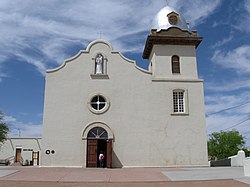
Stations in Texas

[3]

4th Division

5th Division

Captain Pope's New Road

East Mountain at Hueco Tanks State Historic Site Hueco-tanks-east-mtn-tx1.jpg
East Mountain at Hueco Tanks State Historic Site

Captain Pope's New Road ran from Franklin to Horse Head Crossing Station (1st route used, until August 1, 1859 when route was moved to the Lower Road.)
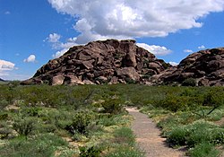
Ruins at The Pinery in Guadalupe Mountains National Park Pinery 2.JPG
Ruins at The Pinery in Guadalupe Mountains National Park

Lower Road

Ysleta mission church Ysleta Del Sur church.jpg
Ysleta mission church

The Lower Road ran from Franklin to Horse Head Crossing Station (used from August 1, 1859)

  • Ysleta - Located 14 miles from Franklin.
  • Socorro - Located 3 miles from Ysleta.
Presidio Chapel of San Elizario San Elizario Mission.jpg
Presidio Chapel of San Elizario
Fort Davis National Historic Site Fort Davis National Historic Site FODA1577.jpg
Fort Davis National Historic Site
Grounds of frontier Fort Stockton Fort Stockton parade ground and barracks as seen from the guard house.jpg
Grounds of frontier Fort Stockton

Main 5th Division Route

Horsehead Crossing along the Pecos River Horsehead Crossing, TX DSCN1061.JPG
Horsehead Crossing along the Pecos River
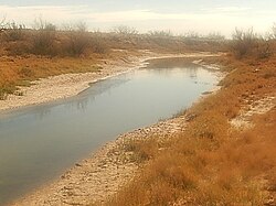
  • Horse Head Crossing Station - On the Pecos River, located 55 miles from Emigrant Crossing Station on the northern route and 45 miles from Camp Stockton on the Lower Road. A ferry was added to carry coaches across the Pecos River from August 1, 1859. [10]
    • Castle Gap Station- Located 12 miles from Horse Head Crossing Station, 17 miles to Wild China Ponds. [4] :196
  • Wild China Ponds - Seasonal waterholes between Horsehead Crossing and Head of Concho, nearest Horse Head Crossing. 17 miles from Castle Gap Station, 19 miles from Llano Estacado Station. [4] :196,197,211,213,214,387n39
    • Llano Estacado Station - Later station, built in 1859, midway between Horse Head Crossing and Head of Concho. 48 miles from Horse Head Crossing, 36 miles from Castle Gap Station. [4] :187,192–196,212,213,384n4
  • Mustang Waterholes - Seasonal waterholes between Horsehead Crossing and Head of Concho, 12 – 14 miles from Head of Concho in Centralia Draw. [4] :188,192,209,210
    • Camp Johnston Station - Later station built in 1859, between Horse Head Crossing and Head of Concho, 19 miles from Llano Estacado Station; 12 miles from Head of Concho in Centralia Draw just east of the Mustang Waterholes. [4] :187,188–189,206,207,381n3,384n2,385n6
  • Head of Concho Station - Located 70 miles from Horsehead Crossing, no water on the route except at station.
Fort Chadbourne stage station Fort Chadbourne Stage Station.jpg
Fort Chadbourne stage station

6th Division

Guard House at Fort Phantom Hill Fort Phantom Hill Guard House.jpg
Guard House at Fort Phantom Hill
Museum at Fort Belknap The Fort Belknap Museum.jpg
Museum at Fort Belknap

6th Division alternate route

The 6th Division alternate route was between Jacksboro and Gainesville Stations August 1860 - March 1861

See also

Related Research Articles

<span class="mw-page-title-main">Pecos County, Texas</span> County in Texas, United States

Pecos County is a county located in the U.S. state of Texas. As of the 2020 census, its population was 15,193. The county seat is Fort Stockton. The county was created in 1871 and organized in 1875. It is named for the Pecos River. It is one of the nine counties that comprise the Trans-Pecos region of West Texas.

<span class="mw-page-title-main">Fort Stockton, Texas</span> City in Texas, United States

Fort Stockton is a city in and the county seat of Pecos County, Texas, United States. It is located on Interstate 10, future Interstate 14, U.S. Highways 67, 285, and 385, and the Santa Fe Railroad, 329 mi (529 km) northwest of San Antonio and 240 mi (390 km) southeast of El Paso. Its population was 8,283 at the 2010 census.

The Butterfield Overland Mail in Indian Territory was part of the overall Butterfield Overland Mail service (1857–1861) created by Congress March 3, 1857. The route crossed Indian Territory from Colbert's Ferry to Fort Smith, Arkansas which was the Center for the Overland Mail's' 7th Division. Fort Smith was also the junction point of the south bound coaches with the Memphis mail and its passengers. From Fort Smith the 7th Division route crossed the Poteau River into Indian Territory into the Choctaw Nation at Skullyville and left the Chickasaw Nation at Colbert's Ferry into Texas. There were 12 stage stations in Indian Territory, located from 13 to 19 miles (31 km) apart. The total length of the route across the territory was approximately 197 miles (317 km). The Butterfield route met with the Texas Road near Geary's Station and followed it southward to the Red River.

<span class="mw-page-title-main">Fort Chadbourne</span> United States historic place

Fort Chadbourne was a fort established by the United States Army on October 28, 1852, in what is now Coke County, Texas, to protect the western frontier and the Butterfield Overland Mail route. It was named after Lt. T.L. Chadbourne, who was killed in the Battle of Resaca de la Palma. It was defended by Companies A and K of the 8th U.S. Infantry. During the early days of the American Civil War, the fort surrendered to the Confederates on February 28, 1861, even before the Confederate shelling of Fort Sumter, South Carolina, but was reoccupied by federal troops from 1865 to 1867.

<span class="mw-page-title-main">Horsehead Crossing</span> Ford in Pecos County, Texas

Horsehead Crossing is a ford on the Pecos River in Crane County, south of Odessa, Texas. Historically, it was a major landmark on the trail west as one of a few fordable sections of the Pecos in West Texas, and as the first reliable source of water for about 75 miles on the route from the east.

The San Antonio–El Paso Road, also known as the Lower Emigrant Road or Military Road, was an economically important trade route between the Texas cities of San Antonio and El Paso between 1849 and 1882. Mail, freight, and passengers traveled by horse and wagon along this road across the Edwards Plateau and dangerous Trans-Pecos region of West Texas.

<span class="mw-page-title-main">Butterfield Overland Mail in California</span> Historic route by state

The Butterfield Overland Mail in California was created by the United States Congress on March 3, 1857, and operated until June 30, 1861. Subsequently, other stage lines operated along the Butterfield Overland Mail in route in Alta California until the Southern Pacific Railroad arrived in Yuma, Arizona in 1877.

<span class="mw-page-title-main">Southern Emigrant Trail</span> 19th-century immigrant route in the United States

Southern Emigrant Trail, also known as the Gila Trail, the Kearny Trail, Southern Trail and the Butterfield Stage Trail, was a major land route for immigration into California from the eastern United States that followed the Santa Fe Trail to New Mexico during the California Gold Rush. Unlike the more northern routes, pioneer wagons could travel year round, mountain passes not being blocked by snows; however, it had the disadvantage of summer heat and lack of water in the desert regions through which it passed in New Mexico Territory and the Colorado Desert of California. Subsequently, it was a route of travel and commerce between the eastern United States and California. Many herds of cattle and sheep were driven along this route and it was followed by the San Antonio-San Diego Mail Line in 1857–1858 and then the Butterfield Overland Mail from 1858 to 1861.

The San Antonio–San Diego Mail Line, also known as the Jackass Mail, was the earliest overland stagecoach and mail operation from the Eastern United States to California in operation between 1857 and 1861. It was created, organized and financed by James E. Birch the head of the California Stage Company. Birch was awarded the first contract for overland service on the "Southern Route", designated Route 8076. This contract required a semi-monthly service in four-horse coaches, scheduled to leave San Antonio and San Diego on the ninth and the 24th of each month, with 30 days allowed for each trip.

The Butterfield Overland Mail was a transport and mail delivery system that employed stagecoaches that travelled on a specific route between St. Louis, Missouri and San Francisco, California and which passed through the New Mexico Territory. It was created by the United States Congress on March 3, 1857, and operated until March 30, 1861. The route that was operated extended from where the ferry across the Colorado River to Fort Yuma Station, California was located, through New Mexico Territory via, Tucson to the Rio Grande and Mesilla, New Mexico then south to Franklin, Texas, midpoint on the route. The New Mexico Territory mail route was divided into two divisions each under a superintendent. Tucson was the headquarters of the 3rd Division of the Butterfield Overland Mail Company. Franklin Station in the town of Franklin,, was the headquarters of the 4th Division.

<span class="mw-page-title-main">Pinery Station</span> Overland Mail stagecoach stop in Texas

Pinery Station, or The Pinery, was built as a relay station on the Butterfield Overland Mail stagecoach route, located at the crest of Guadalupe Pass in what is now Guadalupe Mountains National Park in the U.S. state of Texas. The station, now in ruins, was built in 1858 and was abandoned the next year. It is located close by U.S. Routes 62/160 and is accessible for tourists.

The Stockton–Los Angeles Road, also known as the Millerton Road, Stockton–Mariposa Road, Stockton–Fort Miller Road or the Stockton–Visalia Road, was established about 1853 following the discovery of gold on the Kern River in Old Tulare County. This route between Stockton and Los Angeles followed by the Stockton–Los Angeles Road is described in "Itinerary XXI. From Fort Yuma to Benicia, California", in The Prairie Traveler: A Hand-book for Overland Expeditions by Randolph Barnes Marcy. The Itinerary was derived from the report of Lieutenant R. S. Williamson on his topographical survey party in 1853, that was in search of a railroad route through the interior of California.

<span class="mw-page-title-main">Cornudas, Texas</span> Unincorporated community in Texas, United States

Cornudas is an unincorporated community in Hudspeth County, Texas, United States. Cornudas is located near the intersection of Ranch to Market Road 2317 and the concurrent U.S. Highways 62 and 180, 42 miles (68 km) northwest of the county seat, Sierra Blanca. Cornudas was located in 1929 strategically on the most direct route between El Paso, Texas and Carlsbad, New Mexico as a natural rest and resupply station. It was directly or indirectly named for the Cornudas Mountains that can be seen behind the Cornudas Cafe.

Tejon Creek, originally in Spanish Arroyo de Tejon, is a stream in Kern County, California. Its headwaters are located on the western slopes of the Tehachapi Mountains, and it flows northwest into the southern San Joaquin Valley.

The Butterfield Overland Mail route in Baja California was created as a result of an act by the United States Congress on March 3, 1857, and operated until June 30, 1861 as part of the Second Division of the route. Subsequently other stage lines operated along the route until the Southern Pacific Railroad arrived in Yuma, Arizona.

Birchville, or Smith Ranch, now a ghost town, in what is now Hudspeth County, Texas. Birchville was a settlement on the San Antonio-El Paso Road in what was El Paso County. Birchville lay 35 miles northwest of the First Camp on Rio Grande and 24.8 miles southeast of San Elizario, according to the table of distances for the San Antonio-San Diego Mail Line in the Texas Almanac of 1857. Later used as a station on the Butterfield Overland Mail, the distances to the station for that line were given as 2412 miles from San Elizario, 33 miles from Fort Quitman.

Leaving of Pecos was originally a camping place along the west bank of the Pecos River, on the wagon road called the Lower Emigrant Road, Military Road or San Antonio-El Paso Road in Texas. It was located 38 miles north of the Lancaster Crossing of the Pecos, and 16 miles east of the first crossing of Escondido Creek. It was also located a mile north of where the wagon road had its junction with a cutoff to the north to the wagon road called the Upper Emigrant Road between Fredericksburg, Texas and Comanche Springs, now Fort Stockton, Texas, where it joined the Lower Emigrant Road. It was later a stopping place on the route of San Antonio - El Paso Mail and the San Antonio-San Diego Mail Line.

Limpia Creek, originally known as the Rio Limpia, is a stream that heads in Jeff Davis County, Texas and its mouth is in Pecos County, Texas. Limpa is the Spanish word for "clear or clean water". The creek has its head in the Davis Mountains at an elevation of 7,160 feet, at location 30°38′27″N104°09′42″W on the northeast slope of Mount Livermore. The creek flows 42 miles down Limpia Canyon past Fort Davis and Wild Rose Pass to the canyon mouth, where it turns eastward to its mouth at its confluence with Barrilla Draw, where it disappears into the ground at an elevation of 3,533 feet / 1,077 meters.

<span class="mw-page-title-main">Comanche Springs (Texas)</span>

Comanche Springs was an aquifer of six artesian springs geographically located between the Edwards Plateau and the Trans-Pecos regions of West Texas. The military fortification Camp Stockton was built around the springs, eventually growing become the city of Fort Stockton.

Pope's Crossing was a ford on the Pecos River located one mile south of the New Mexico–Texas border on the modern Loving–Reeves county line. Discovered by members of an 1855 expedition tasked with drilling artesian wells east of the Pecos led by U.S. Army topographical engineer John Pope, the ford quickly became the primary crossing of the river on the "upper" military or emigrant road between San Antonio and the ford on the Rio Grande opposite the Mexican town of El Paso del Norte. Heavily used by emigrants, soldiers, traders, and freighters eager to avoid the more difficult and unpredictable crossings further south, Pope's Crossing became a well-traveled part of the network of transcontinental wagon roads that developed across Texas in the 1850s to facilitate settlement and commerce in the southwestern lands recently acquired as a result of the Mexican–American War.

References

  1. Staff. "Butterfield Overland Mail Route Corridor, National Register of Historic Places Program". National Park Service. Retrieved October 14, 2016.
  2. "National Register of Historic Places Inventory - Nomination Form: Butterfield Overland Mail Corridor" (PDF). Texas Historical Commission . Retrieved October 14, 2016.
  3. Mileage of original stations from List of Stations from New York Times, October 14, 1858, Itinerary of the Route. Other mileage from note for that entry.
  4. 1 2 3 4 5 6 7 8 9 10 11 12 13 14 15 16 17 18 19 20 21 22 23 24 25 Glen Sample Ely, The Texas Frontier and the Butterfield Overland Mail, 1858–1861, University of Oklahoma Press, Norman, Mar 4, 2016
  5. A. C. Greene, 900 Miles on the Butterfield Trail, p.75
  6. Julia Cauble Smith, "POPE'S CAMP," Handbook of Texas Online (https://tshaonline.org/handbook/online/articles/uzp03), accessed May 17, 2011. Published by the Texas State Historical Association
  7. "EAGLE SPRING," Handbook of Texas Online (https://tshaonline.org/handbook/online/articles/rpe01), accessed May 17, 2011. Published by the Texas State Historical Association.
  8. 1 2 Beale, Edward Fitzgerald (1858). Wagon Road from Fort Defiance to the Colorado River: Letter from the Secretary of War, Transmitting the Report of the Superintendent of the Wagon Road from Fort Defiance to the Colorado River: Issue 124 of [U.S.] 35th Cong., 1st sess. House. Ex. doc. [U.S.] 35th Cong., 1st sess. House. Ex. Doc.no. 124. Harvard University.
  9. Ernest Wallace, "FORT STOCKTON," Handbook of Texas Online (https://tshaonline.org/handbook/online/articles/qbf46), accessed May 17, 2011. Published by the Texas State Historical Association
  10. Glenn Justice, "HORSEHEAD CROSSING," Handbook of Texas Online (https://tshaonline.org/handbook/online/articles/rih01), accessed May 17, 2011. Published by the Texas State Historical Association.