Birchville, Texas

Last updated
Birchville, Texas
Ghost Town
Nickname(s): 
Smith's Ranch
Relief map of Texas.png
Red pog.svg
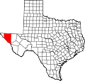
Birchville
Location within Texas
Coordinates: 31°22′30″N105°57′57″W / 31.37500°N 105.96583°W / 31.37500; -105.96583 Coordinates: 31°22′30″N105°57′57″W / 31.37500°N 105.96583°W / 31.37500; -105.96583
Country United States
State Texas
County Hudspeth
Time zone UTC-7 (Mountain (MST))
  Summer (DST) UTC-6 (MDT)
GNIS feature ID 2034616

Birchville, or Smith Ranch, now a ghost town, in what is now Hudspeth County, Texas. Birchville was a settlement on the San Antonio-El Paso Road in what was El Paso County. Birchville lay 35 miles northwest of the First Camp on Rio Grande and 24.8 miles southeast of San Elizario, according to the table of distances for the San Antonio-San Diego Mail Line in the Texas Almanac of 1857. [1] Later used as a station on the Butterfield Overland Mail, the distances to the station for that line were given as 2412 miles from San Elizario, 33 miles from Fort Quitman. [2]

Ghost town City depopulated of inhabitants and that stays practically intact

A ghost town is an abandoned village, town, or city, usually one that contains substantial visible remains. A town often becomes a ghost town because the economic activity that supported it has failed, or due to natural or human-caused disasters such as floods, prolonged droughts, government actions, uncontrolled lawlessness, war, pollution, or nuclear disasters. The term can sometimes refer to cities, towns, and neighbourhoods that are still populated, but significantly less so than in past years; for example, those affected by high levels of unemployment and dereliction.

Hudspeth County, Texas County in the United States

Hudspeth County is a county located in the U.S. state of Texas. As of the 2010 census, the population was 3,476. Its county seat is Sierra Blanca, and the largest community is Fort Hancock. The county is named for Claude Benton Hudspeth, a state senator and United States Representative from El Paso. It is northeast from the Mexican border.

El Paso County, Texas County in the United States

El Paso County is the westernmost county in the U.S. state of Texas. As of the 2010 census, the population was 800,647, making it the sixth-most populous county in the state of Texas. Its seat is the city of El Paso, the sixth-most populous city in Texas and the 19th-most populous city in the United States. The county was created in 1850 and later organized in 1871.

Contents

History

Birchville, or Smith Ranch Station, was a stop on the San Antonio-San Diego Mail Line in 1857, [1] and from 1858 to 1861 a stagecoach station on the Butterfield Overland Mail route. [2] Its station agent George Lyles, was a grocer that lived there with his family. Also two employees lived in the household including a cook. [3] An eating house provided travelers a meal during stagecoach stops while the horses were being changed. It remained as a station of Butterfield Overland Mail's successor the Overland Mail until 1862 when the Union Army occupied El Paso County.

Butterfield Overland Mail

Butterfield Overland Mail was a stagecoach service in the United States operating from 1858 to 1861. It carried passengers and U.S. Mail from two eastern termini, Memphis, Tennessee, and St. Louis, Missouri, to San Francisco, California. The routes from each eastern terminus met at Fort Smith, Arkansas, and then continued through Indian Territory (Oklahoma), Texas, New Mexico, Arizona, Mexico, and California ending in San Francisco. On March 3, 1857, Congress authorized the U.S. postmaster general, Aaron Brown, to contract for delivery of the U.S. mail from Saint Louis to San Francisco. Prior to this, U.S. Mail bound for the Far West had been delivered by the San Antonio and San Diego Mail Line since June 1857.

Union Army Land force that fought for the Union during the American Civil War

During the American Civil War, the Union Army referred to the United States Army, the land force that fought to preserve the Union of the collective states. Also known as the Federal Army, it proved essential to the preservation of the United States as a working, viable republic.

During the American Civil War, Lyles remained in the area providing mesquite beans, to the Union Army garrison at Franklin, Texas (El Paso). [4] When Bethel Coopwood revived the San Antonio-El Paso Mail in 1866, Birchville was again a stagecoach station but the settlement was destroyed by a flood of the Rio Grande in 1867 and never revived.

American Civil War Civil war in the United States from 1861 to 1865

The American Civil War was a civil war fought in the United States from 1861 to 1865, between the North (Union) and the South (Confederacy). The most studied and written about episode in U.S. history, the Civil War began primarily as a result of the long-standing controversy over the enslavement of black people. War broke out in April 1861 when secessionist forces attacked Fort Sumter in South Carolina shortly after Abraham Lincoln had been inaugurated as the President of the United States. The loyalists of the Union in the North proclaimed support for the Constitution. They faced secessionists of the Confederate States in the South, who advocated for states' rights to uphold slavery.

Bethel Coopwood Confederate Army officer

Bethel Coopwood (1827–1907) was a soldier in the Mexican–American War and the American Civil War, a lawyer, judge, and historian.

Rio Grande River forming part of the US-Mexico border

The Rio Grande is one of the principal rivers in the southwest United States and northern Mexico. The Rio Grande begins in south-central Colorado in the United States and flows to the Gulf of Mexico. Along the way, it forms part of the Mexico–United States border. According to the International Boundary and Water Commission, its total length was 1,896 miles (3,051 km) in the late 1980s, though course shifts occasionally result in length changes. Depending on how it is measured, the Rio Grande is either the fourth- or fifth-longest river system in North America.

Location of the site

The exact location of Birchville has yet to be found. It may have been obliterated by the floods of the Rio Grande in 1867 or during the later 19th century, or buried under agricultural lands along the river. Mileage from San Elizario on the old road put it approximately 2 miles south of the El Paso - Hudspeth County line nearby Texas State Highway 20.

Texas State Highway 20 highway in Texas

State Highway 20 or SH 20 is a 78.1-mile (125.7 km) highway maintained by the Texas Department of Transportation (TxDOT) that runs from New Mexico State Road 460 at the state line between Texas and New Mexico at Anthony in El Paso County to Interstate 10 at McNary in Hudspeth County. It largely follows a former alignment of U.S. Route 80. The route passes through the city of El Paso as well as suburban and rural farming communities along the Rio Grande. With the exception of a stretch north of central El Paso where the route crosses north of I-10, the route generally runs in a narrow belt between I-10 and the Rio Grande. The route has connections to every international border crossing with Mexico in the El Paso area and has important intersections with US 54, US 62, US 85, and US 180.

Related Research Articles

The San Antonio–El Paso Road also known as the Lower Emigrant Road or Military Road was an economically important trade route between the Texas cities of San Antonio and El Paso between 1849 and 1882. The road carried mail, freight and passengers by horse and wagon across the Edwards Plateau and dangerous Trans-Pecos region of West Texas.

Fort Quitman Ghost Town in Texas, United States

Fort Quitman was a United States Army installation on the Rio Grande in Texas, south of present-day Sierra Blanca, 20 miles southeast of McNary in southern Hudspeth County. The fort, now a ghost town, was named for Mississippi Governor John A. Quitman, who served as a major general under Zachary Taylor during the Mexican–American War.

The San Antonio–San Diego Mail Line, also known as the Jackass Mail, was the earliest overland stagecoach and mail operation from the Eastern United States to California in operation between 1857 and 1861. It was created, organized and financed by James E. Birch the head of the California Stage Company. Birch was awarded the first contract for overland service on the "Southern Route", designated Route 8076. This contract required a semi-monthly service in four-horse coaches, scheduled to leave San Antonio and San Diego on the ninth and the 24th of each month, with 30 days allowed for each trip.

Butterfield Overland Mail in Texas

In Texas, the Butterfield Overland Mail service created by Congress on March 3, 1857, operated until March 30, 1861. The route that was operated extended from San Francisco, California to Los Angeles, then across the Colorado Desert to Fort Yuma, then across New Mexico Territory via, Tucson and Mesilla, New Mexico to Franklin, Texas, midpoint on the route. The route through Texas followed first the northern route to the Pecos River and downstream to Horse Head Crossing. The route in West Texas was changed in 1859, in order to secure a better water supply on the route and to provide mail service to a more settled area, the stages between Franklin and the Pecos River followed the San Antonio-El Paso Road to Camp Stockton and then turned east to Horsehead Crossing. From Horsehead Crossing the route crossed Texas to the Red River and into Indian Territory. In 1860 the route was changed to another route from Jacksboro to Sherman via Decatur due to the building of a new toll bridge at Bridgeport, that avoided delays crossing the West Fork of the Trinity River when it was flooded. From Colberts Ferry the route went on to Fort Smith, then up across Arkansas and southwest Missouri to Tipton with the final leg by train to St. Louis. The Texas mail route was so long that the route there, like that in California, was divided into two divisions each under a superintendent.

Birchville usually refers to a suburb of Upper Hutt in New Zealand. However, there are several other places in the world that either are, or have previously been named Birchville. Consider these alternatives:

Leon Creek, is a tributary stream of the Medina River, in Bexar County, Texas.

Seco Creek, is a tributary stream of the Hondo Creek, in Frio County, Texas. Named Rio Seco in 1689 by Captain Alonso De León, governor of Coahuila, when his expedition crossed the creek.

Rancheros Creek river in the United States of America

Rancheros Creek is a tributary stream of the Sabinal River, in Medina County and Uvalde County, Texas.

Cottonwoods Station was a stop on the San Antonio-San Diego Mail Line and later the Butterfield Overland Mail stagecoach station in El Paso County, Texas.

Dragoon Wash, a stream tributary to the San Pedro River, in Cochise County, Arizona. It has its source just southwest of the town of Dragoon. 32°01′21″N110°02′46″W It runs southwesterly to meet the San Pedro River.

The First Crossing of Devils River was the first point at which the Devils River was crossed by the San Antonio-El Paso Road. It was located 10.22 miles west of San Felipe Springs at the mouth of San Pedro Creek on the Devils River. It was 2.54 miles southeast of Painted Caves, on California Creek, a noted camp location on the road. The crossing point and the gorge leading down to it from the east are now submerged under Lake Amistad.

Socatoon Station, was a stagecoach station of the Butterfield Overland Mail between 1858-1861. It was located four miles east of Sacaton a Maricopa village from which it took its name. This station was located 22 miles east of Maricopa Wells Station and 11 miles east of Casa Blanca Station and 13 miles north of Oneida Station.

Pinto Creek, formerly known as Piedra Pinto Creek, a tributary to the Rio Grande in Kinney County, Texas. It has its source, at 29°30′53″N100°24′13″W.

Cow Springs Ranch is a locale, located in Luna County, New Mexico. The ranch headquarters is located at Cow Springs, originally Ojo de Vaca.

Cienega of San Simon, was a cienega, an area of springs 13 miles up the San Simon River from San Simon Station, in Cochise County, Arizona.

Leaving of Pecos was originally a camping place along the west bank of the Pecos River, on the wagon road called the Lower Emigrant Road, Military Road or San Antonio-El Paso Road in Texas. It was located 38 miles north of the Lancaster Crossing of the Pecos, and 16 miles east of the first crossing of Escondido Creek. It was also located a mile north of where the wagon road had its junction with a cutoff to the north to the wagon road called the Upper Emigrant Road between Fredricksburg, Texas and Comanche Springs, now Fort Stockton, Texas, where it joined the Lower Emigrant Road. It was later a stopping place on the route of San Antonio - El Paso Mail and the San Antonio-San Diego Mail Line.

Point of Rocks also known as Bald Rock, is a hill and a locale in Jeff Davis County, Texas. Point of Rocks, is an isolated hill with a spring once known as Bald Rock Spring. It was used as a watering place and campsite on the San Antonio-El Paso Road, 10 miles west of Fort Davis, Texas, now Point of Rocks Roadside Park. The elevation of Point of Rocks Spring, is at 5,469 feet / 1,667 meters, at the foot of the southeast slope of the Point of Rocks that reaches over 5,920 feet along its crest.

Antelope Peak Station Locale in Arizona, United States

Antelope Peak Station, a later Butterfield Overland Mail station located 15.14 miles east of Mission Camp, at the foot of Antelope Peak. It replaced Filibusters Camp Station, 6 miles to the west. The Overland Mail Company replaced Filibusters Camp, because Antelope Peak Station had a better water supply. Its location is thought to be 32°42′47.17″N114°00′54.3″W.

Limpia Creek, originally known as the Rio Limpia, is a stream that heads in Jeff Davis County, Texas and its mouth is in Pecos County, Texas. Limpa is the Spanish word for "clear or clean water". The creek has its head in the Davis Mountains at an elevation of 7,160 feet, at location 30°38′27″N104°09′42″W on the northeast slope of Mount Livermore. The creek flows 42 miles down Limpia Canyon past Fort Davis and Wild Rose Pass to the canyon mouth, where it turns eastward to its mouth at its confluence with Barrilla Draw, where it disappears into the ground at an elevation of 3,533 feet / 1,077 meters.

References

  1. 1 2 Table of distances from Texas Almanac, 1859, Book, ca. 1859; digital images, (http://texashistory.unt.edu/ark:/67531/metapth123765/ accessed November 12, 2013), University of North Texas Libraries, The Portal to Texas History, http://texashistory.unt.edu; crediting Texas State Historical Association, Denton, Texas
  2. 1 2 List of Stations from New York Times, October 14 1858, Itinerary of the Route
  3. George B. Lyles & Basilia McKnight; 1860 Census, Fort Quitman, El Paso County, Texas from George B. Lyles accessed December 1, 2013
  4. George B. Lyles & Basilia McKnight from sites.google.com/site/georgeblylesbasilicamcknight/Home/george-b-lyles accessed December 1, 2013