This page is based on this
Wikipedia article Text is available under the
CC BY-SA 4.0 license; additional terms may apply.
Images, videos and audio are available under their respective licenses.

Yakoruda Glacier is a glacier on the west slopes of Dryanovo Heights, Greenwich Island in the South Shetland Islands, Antarctica situated west of Teteven Glacier and northwest of Murgash Glacier. It extends 3.5 km in north-south direction and 2.5 km in east-west direction, is bounded by Greaves Peak, Hrabar Nunatak and Crutch Peak to the north, Lloyd Hill to the east and Kerseblept Nunatak to the south, and drains westwards into Berende Cove, McFarlane Strait.
Eakin Creek Floodplain Provincial Park is a provincial park in British Columbia, Canada located on the North Thompson River near the community of Little Fort.
Eakin Creek Canyon Provincial Park is a provincial park in British Columbia, Canada, located on the west side of the North Thompson River near the community of Little Fort. The park is approximately 10 ha. in size.
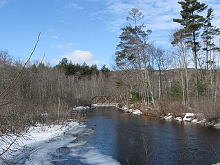
The Merrymeeting River is a 10.0-mile-long (16.1 km) river located in the Lakes Region of central New Hampshire in the United States. It is a tributary of Lake Winnipesaukee, part of the Merrimack River watershed.

St. Michael Island is an island on the southeast side of the Norton Sound in Alaska. The island is about 9.3 miles (15.0 km) long and 6.2 miles (10.0 km) wide.
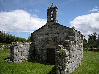
O Valadouro is a municipality in the Galician province of Lugo. O Valadouro belongs to the region of A Mariña Central. Its capital is the town of Ferreira. In 2011, it had 2,180 inhabitants according to the INE.
WDVM is a radio station in Eau Claire, Wisconsin, United States. It is part of the Relevant Radio Christian network.
Asturianos is a municipality located in the Sanabria comarca, province of Zamora, Castile and León, Spain. According to the 2009 census (INE), the municipality had a population of 267 inhabitants. The Leonese language is still spoken here. It is on the Sanabres variant of the Via de la Plata pilgrim camino to Santiago de Compostela.

Hoosierville is an unincorporated community in Jackson Township, Clay County, Indiana. It is part of the Terre Haute Metropolitan Statistical Area.
Mount Olympus is an unincorporated community in Washington Township, Gibson County, Indiana. It was formerly called Ennes. A post office called Ennes operated from 1879 until 1883.

Zenas is an unincorporated community in Columbia Township, Jennings County, Indiana.

Kot Mubarak is a town and union council of Dera Ghazi Khan District in the Punjab province of Pakistan. It is located at 31°13'35N 70°28'30E and has an altitude of 202 metres.

Lasca is an unincorporated community in Marengo County, Alabama, United States.

Ensign is a hamlet in southern Alberta, Canada within Vulcan County. It is located approximately 11 kilometres (6.8 mi) south of Highway 23 and 78 kilometres (48 mi) southeast of Calgary.
Morochata is a location in the Cochabamba Department in central Bolivia. It is the seat of the Morochata Municipality, the second municipal section of the Ayopaya Province.
Olney Corner is an unincorporated community in Caroline County, in the U.S. state of Virginia.
Dry Branch is an unincorporated community in Pulaski County, in the U.S. state of Virginia.
Hubbells Corner is an unincorporated community in Dearborn County, Indiana, in the United States.

Castilla is a ward (barrio) of Madrid belonging to the district of Chamartín.