McNary, Texas

Last updated

McNary, Texas
Unincorporated Community
Relief map of Texas.png
Red pog.svg
McNary
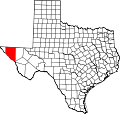
Location within Texas
Coordinates: 31°14′53″N105°47′47″W / 31.24806°N 105.79639°W / 31.24806; -105.79639
CountryUnited States
State Texas
County Hudspeth
Elevation
[1]
3,576 ft (1,090 m)
Time zone UTC-6 (Central (CST))
  Summer (DST) UTC-5 (CDT)
ZIP codes
79839
Area code 915
GNIS feature ID1362526 [1]

McNary is an unincorporated community (pop. ~250) at the intersection of Interstate 10 and State Highway 20. It is two miles from the Rio Grande and 23 miles west of Sierra Blanca in southwestern Hudspeth County, Texas, United States.

The area was initially settled in 1921, and named Nulo. The town was renamed McNary, after James G. McNary (1877-1962), a local businessman, in September 1923 when the Galveston, Harrisburg and San Antonio Railway established a station in the area. It served as a shipping point for cotton from the Algodon Plantation. [2]

Related Research Articles

<span class="mw-page-title-main">McMullen County, Texas</span> County in Texas, United States

McMullen County is a county located in the U.S. state of Texas. As of the 2020 census, its population was 600, making it the fourth-least populous county in Texas. Its county seat is Tilden. The county was established from parts of Bexar County, Atascosa County, and Live Oak County in 1858 and later organized in 1877. It is named for John McMullen, founder of a colony in Texas. The McMullen County Courthouse was designed by the architect W.C. Stephenson, originally from Buffalo, New York. Stephenson also designed some 50 buildings in Beeville, including the Bee County Courthouse.

<span class="mw-page-title-main">McLennan County, Texas</span> County in Texas, United States

McLennan County is a county located on the Edwards Plateau in Central Texas. As of the 2020 census, its population was 260,579. Its county seat and largest city is Waco. The U.S. census 2023 county population estimate is 268,583. The county is named for Neil McLennan, an early Scottish settler who worked to evict the Native Americans in frontier Texas. McLennan County is included in the Waco Metropolitan Statistical Area.

<span class="mw-page-title-main">McCulloch County, Texas</span> County in Texas, United States

McCulloch County is a county located on the Edwards Plateau in the U.S. state of Texas. At the 2020 census, its population was 7,630. Its county seat is Brady. The county was created in 1856 and later organized in 1876. It is named for Benjamin McCulloch, a famous Texas Ranger and Confederate general.

<span class="mw-page-title-main">Hudspeth County, Texas</span> County in Texas, United States

Hudspeth County is a county located in the U.S. state of Texas. As of the 2020 census, the population was 3,202. Its county seat is Sierra Blanca, and the largest community is Fort Hancock. The county is named for Claude Benton Hudspeth, a state senator and United States Representative from El Paso. It is northeast of the Mexico–U.S. border.

<span class="mw-page-title-main">McNary, Arizona</span> CDP in Apache and Navajo Counties, Arizona

McNary is a census-designated place (CDP) in Apache and Navajo counties in the U.S. state of Arizona, on the Fort Apache Indian Reservation. The population was 528 at the 2010 census.

<span class="mw-page-title-main">McNary, Louisiana</span> Village in Louisiana, United States

McNary is a village in Rapides Parish, Louisiana, United States. It is part of the Alexandria, Louisiana, Metropolitan Statistical Area. The population was 211 at the 2000 census.

<span class="mw-page-title-main">Keizer, Oregon</span> City in Oregon, United States

Keizer is a city located in Marion County, Oregon, United States, along the 45th parallel. As of the 2020 United States Census, its population was 39,376, making it the 14th most populous city in Oregon. It lies in the Willamette Valley, and is part of the Salem Metropolitan Statistical Area. It was named after pioneer Thomas Dove Keizur and his family, who arrived in the Wagon Train of 1843, and later filed donation land claims.

<span class="mw-page-title-main">Temple, Texas</span> City in Texas, United States

Temple is a city in Bell County, Texas, United States. As of 2020, the city has a population of 82,073 according to the U.S. census. Temple lies in the region referred to as Central Texas and is a principal city in the Killeen–Temple–Fort Hood metropolitan area, {Fort Hood was redesignated "Fort Cavazos" in 2023} which as of the 2020 Census had a population of 475,367. Located off Interstate 35, Temple is 65 miles north of Austin, 34 miles south of Waco and 27 miles east of Killeen.

<span class="mw-page-title-main">Clarksville, Texas</span> City in Texas, United States

Clarksville is a city and county seat of Red River County, Texas, United States, in the northernmost part of the Piney Woods region of East Texas. As of the 2020 census, the city population was 2,857.

<span class="mw-page-title-main">Rockwall, Texas</span> City in Texas, United States

Rockwall is a city in Rockwall County, Texas, United States, that is part of the Dallas/Fort Worth metroplex. It is the county seat of Rockwall County. The U.S. Census Bureau estimates that as of the 2020 census, Rockwall's population is 47,251, up from 45,888 in 2019. The name Rockwall is derived from a naturally jointed geological formation, which has the appearance of an artificial wall.

<span class="mw-page-title-main">Ark-La-Tex</span> Region in the United States

The Ark-La-Tex is a socio-economic tri-state region where the Southern U.S. states of Arkansas, Louisiana, and Texas join together. The region contains portions of Northwest Louisiana, Northeast Texas, and South Arkansas as well as the extreme southeastern tip of Oklahoma, in McCurtain County, partly centered upon the Red River, which flows along the Texas–Oklahoma state line into Southwestern Arkansas and Northwest Louisiana.

<span class="mw-page-title-main">McNary Dam</span> Dam in Oregon, USA

McNary Dam is a 1.4-mile (2.2-km) long concrete gravity run-of-the-river dam which spans the Columbia River. It joins Umatilla County, Oregon with Benton County, Washington, 292 miles (470 km) upriver from the mouth of the Columbia. It is operated by the U.S. Army Corps of Engineers' McNary Lock and Dam office. The dam is located a mile (2 km) east of the town of Umatilla, Oregon, and 8 miles (13 km) north of Hermiston, Oregon. The dam was originally planned to be named Umatilla Dam, but the Flood Control Act of 1945 renamed the dam in honor of Senator Charles L. McNary of Oregon, who had died the previous year.

<span class="mw-page-title-main">Charles L. McNary</span> American politician

Charles Linza McNary was an American Republican politician from Oregon. He served in the U.S. Senate from 1917 to 1944 and was Senate Minority Leader from 1933 to 1944. In the Senate, McNary helped to pass legislation that led to the construction of Bonneville Dam on the Columbia River, and worked on agricultural and forestry issues. He also supported many of the New Deal programs at the beginning of the Great Depression. Until Mark Hatfield surpassed his mark in 1993, he was Oregon's longest-serving senator.

<span class="mw-page-title-main">McNary Field</span> Airport

McNary Field is in Marion County, Oregon, United States, two miles southeast of downtown Salem, which owns it. The airport is named for U.S. Senator Charles L. McNary.

<span class="mw-page-title-main">Texas State Highway 20</span> State highway in Texas

State Highway 20 is a 78.1-mile (125.7 km) highway maintained by the Texas Department of Transportation (TxDOT) that runs from New Mexico State Road 460 at the state line between Texas and New Mexico at Anthony in El Paso County to Interstate 10 at McNary in Hudspeth County. It largely follows a former alignment of U.S. Route 80. The route passes through the city of El Paso as well as suburban and rural farming communities along the Rio Grande. With the exception of a stretch north of central El Paso where the route crosses north of I-10, the route generally runs in a narrow belt between I-10 and the Rio Grande. The route has connections to every international border crossing with Mexico in the El Paso area and has important intersections with US 54, US 62, US 85, and US 180.

<span class="mw-page-title-main">Geography of Texas</span>

The geography of Texas is diverse and large. Occupying about 7% of the total water and land area of the U.S., it is the second largest state after Alaska, and is the southernmost part of the Great Plains, which end in the south against the folded Sierra Madre Oriental of Mexico. Texas is in the South Central United States of America, and is considered to form part of the U.S. South and also part of the U.S. Southwest.

<span class="mw-page-title-main">Hat Rock State Park</span> State park in Oregon, United States

Hat Rock State Park is a state park in the U.S. state of Oregon, administered by the Oregon Parks and Recreation Department. The park is located off the east side of U.S. Highway 730 in Hermiston, on the south shore of Lake Wallula behind McNary Dam on the Columbia River.

<span class="mw-page-title-main">McNary High School</span> Public school in Keizer, Marion County, Oregon, United States

McNary High School (MHS) is the only public high school located in Keizer, Oregon, United States.

McNary National Wildlife Refuge is a wildlife preserve, one of the national wildlife refuges operated by the United States Fish and Wildlife Service. Extending along the east bank of the Columbia River in southeastern Washington, from the confluence of the Snake River to the mouth of the Walla Walla River, and downstream into Oregon, McNary NWR is located in rural Burbank, but very close to the rapid development of the Tri-Cities. In fact, the refuge meets the definition of an "urban refuge." Few areas in North America support waterfowl populations in the extraordinary numbers found here. There are spectacular concentrations of Canada geese, mallards, and other waterfowl. More than half the mallards in the Pacific Flyway overwinter at some time in this portion of the Columbia River Basin.

<span class="mw-page-title-main">McNary Levee System</span>

The McNary Levee System, also known as the Tri-Cities Levees, is an appurtenant or dam-related structure to McNary Lock and Dam, and consists of three groups of levee segments along the banks of the Columbia River that provide flood risk reduction for portions of Kennewick, Pasco, and Richland, Washington. The levee group names are based on location and are identified as the Kennewick Levees, Pasco Levees, and Richland Levees. Lake Wallula behind McNary Lock and Dam is about 63 miles long and includes 242 miles of shoreline and a drainage area of 214,000 square miles. The McNary Levee System consists of about 16.8 miles of earthen levees and 11 operational pump plants that remove agricultural runoff, groundwater migration, and rainfall runoff. Construction of the McNary Levee System began in 1950 and was completed in 1954.

References

  1. 1 2 U.S. Geological Survey Geographic Names Information System: McNary, Texas
  2. Threadgill, Marguerite E. "McNary, Texas". Handbook of Texas Online. Texas State Historical Association.