Vidal Valley

Last updated
Vidal Valley
Parker Valley facing S.jpg
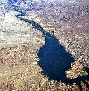
(view to south)
Aerial view of the Parker Valley,
with the extreme southeast exit of Vidal Valley (photo, bottom right) into the Colorado River region (Parker Valley).
Also shows Riverside Mountains & attached West Riverside Mountains at center right.
The Big Maria Mountains are above at right (on horizon) to the south.
The small mountain range across the Colorado River in Arizona (to the east) is the Mesquite Mountains.
USA California Southern location map.svg
Red pog.svg
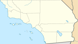
Vidal Valley
Vidal Valley in California
Length 20 miles (32 km)
Width 10 miles (16 km)
Geography
Location San Bernardino County, CA & Riverside County, CA
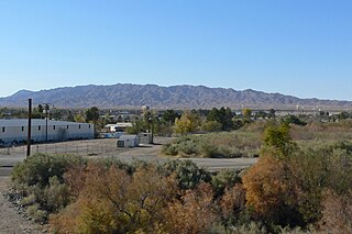
Population centers Vidal Junction, Vidal, Rig River
Coordinates 34°11′20″N114°34′26″W / 34.18889°N 114.57389°W / 34.18889; -114.57389 Coordinates: 34°11′20″N114°34′26″W / 34.18889°N 114.57389°W / 34.18889; -114.57389
Rivers Vidal Wash & Colorado River

Vidal Valley is a 20-mile (32 km) long valley in the far eastern Colorado Desert bordering the Colorado River. Most of the valley is in eastern San Bernardino County, California, but the outfall on the Colorado River is in northeast Riverside County. Vidal Valley forms the large border of the south side of the east-west block of the Whipple Mountains massif, the landform that forces the Colorado to flow southeast, then back southwest. The southeast exit of the valley into Parker Valley on the Colorado River skirts the north end of the Riverside Mountains (see photo). The Colorado River Aqueduct crosses the midpoint of the valley at Vidal Junction, California. The Vidal Valley also lies due east of the Danby Dry Lake landform.

Colorado Desert desert in California, United States

California's Colorado Desert is a part of the larger Sonoran Desert. It encompasses approximately 7 million acres (28,000 km2), including the heavily irrigated Coachella and Imperial valleys. It is home to many unique flora and fauna.

Colorado River major river in the western United States and Mexico

The Colorado River is one of the principal rivers in the Southwestern United States and northern Mexico. The 1,450-mile-long (2,330 km) river drains an expansive, arid watershed that encompasses parts of seven U.S. and two Mexican states. Starting in the central Rocky Mountains of Colorado, the river flows generally southwest across the Colorado Plateau and through the Grand Canyon before reaching Lake Mead on the Arizona–Nevada border, where it turns south toward the international border. After entering Mexico, the Colorado approaches the mostly dry Colorado River Delta at the tip of the Gulf of California between Baja California and Sonora.

San Bernardino County, California County in California, United States

San Bernardino County, officially the County of San Bernardino, is a county located in the southern portion of the U.S. state of California, and is located within the Greater Los Angeles area. As of the 2010 U.S. Census, the population was 2,035,210, making it the fifth-most populous county in California, and the 12th-most populous in the United States. The county seat is San Bernardino.

Contents

Geography

Vidal Valley is bordered by the Whipple Mountains on the northeast and the Riverside Mountains on the south. The valley drains mostly northwest-to-southeast, with its outfall into a southwest-flowing section of the Colorado River. The north of the valley is bordered on the west by the Turtle Mountains, and the south side of the Chemehuevi Valley. The center point of the valley, both east-west and north-south is at Vidal Junction located at U.S. Route 95 in California and California State Route 62. Vidal Junction is located at 34°11′20″N114°34′26″W / 34.18889°N 114.57389°W / 34.18889; -114.57389 .

Whipple Mountains

The Whipple Mountains are located in eastern San Bernardino County, California. They are directly west of the Colorado River, Parker Dam, and Lake Havasu; south of Needles, California; north of Parker, Arizona and Vidal, California; and northeast of Vidal Junction, California.

Riverside Mountains

The Riverside Mountains are a mountain range in Riverside County, California. The town of Vidal, California is located in the West Riverside Mountains.

Turtle Mountains (California)

The Turtle Mountains, are located in northeastern San Bernardino County, in the southeastern part of California.

Natural history

The Vidal Valley is in the climate, ecoregion, and plant community transition zone to the higher Mojave Desert on the north from the lower-elevation Colorado Desert on the south.

Climate Statistics of weather conditions in a given region over long periods

Climate is the statistics of weather over long periods of time. It is measured by assessing the patterns of variation in temperature, humidity, atmospheric pressure, wind, precipitation, atmospheric particle count and other meteorological variables in a given region over long periods of time. Climate differs from weather, in that weather only describes the short-term conditions of these variables in a given region.

Ecoregion Ecologically and geographically defined area that is smaller than a bioregion

An ecoregion is an ecologically and geographically defined area that is smaller than a bioregion, which in turn is smaller than an ecozone. All three of these are either less or greater than an ecosystem. Ecoregions cover relatively large areas of land or water, and contain characteristic, geographically distinct assemblages of natural communities and species. The biodiversity of flora, fauna and ecosystems that characterise an ecoregion tends to be distinct from that of other ecoregions. In theory, biodiversity or conservation ecoregions are relatively large areas of land or water where the probability of encountering different species and communities at any given point remains relatively constant, within an acceptable range of variation.

Plant community collection or association of plant species within a designated geographical unit

A plant community is a collection or association of plant species within a designated geographical unit, which forms a relatively uniform patch, distinguishable from neighboring patches of different vegetation types. The components of each plant community are influenced by soil type, topography, climate and human disturbance. In many cases there are several soil types within a given phytocoenosis.

Watersheds

The Vidal Valley watershed enters the Colorado River opposite the Bouse Wash Watershed in western Arizona. Both watersheds enter the Parker Valley, mostly occupied by the Colorado River Indian Reservation. As desert washes, typically little or no water flows at the outfall points into the Colorado River, except during rainstorm events. Both the Vidal Valley and the Bouse Wash are in the north of the Imperial Reservoir Watershed. [1]

Parker Valley

The Parker Valley is located along the Lower Colorado River within the Lower Colorado River Valley region, in southwestern Arizona and southeastern California.

Arroyo (creek) A dry creek or stream bed with flow after rain

An arroyo, also called a wash, is a dry creek, stream bed or gulch that temporarily or seasonally fills and flows after sufficient rain. Flash floods are common in arroyos following thunderstorms.

Imperial Reservoir

The Imperial Reservoir is an artificial lake formed by the construction of the Imperial Diversion Dam across the Colorado River in the Lower Colorado River Valley of Imperial County, California, and Yuma County, Arizona. A component of the Imperial National Wildlife Refuge, the reservoir is 16 miles (26 km) northeast of Yuma, Arizona.

The headwater region of the valley is north of Vidal Junction; the water divide is east of the Turtle Mountains, and due west of the east-west trending Whipple Mountains block. North of the water divide is the southside of Chemehuevi Valley and Chemehuevi Wash.

Chemehuevi Wash river in the United States of America

The Chemehuevi Wash is a large wash of northeast San Bernardino County in the southeast Mojave Desert. The wash enters the center-west bank of Lake Havasu on the California–Arizona border. Chemehuevi Wash drains the center of the Chemehuevi Valley and the regional landforms of washes, valleys and mountains is adjacent the northeast region of the Colorado Desert, the entire region south on the west side of the south-flowing Colorado River.

See also

Lower Colorado River Valley

The Lower Colorado River Valley ("LCRV") is the river region of the lower Colorado River of the southwestern United States in North America that rises in the Rocky Mountains and has its outlet at the Colorado River Delta in the northern Gulf of California in northwestern Mexico, between the states of Baja California and Sonora. This north–south stretch of the Colorado River forms the border between the U.S. states of California/Arizona and Nevada/Arizona, and between the Mexican states of Baja California/Sonora.

Tyson Wash

Tyson Wash is one of the larger eastern-bank dry washes that enter the Colorado River in western Arizona. It drains the La Posa Plain south-to-north and is also coincident with the Plain,.

Related Research Articles

Mohave Valley valley in Arizona, United States of America

The Mohave Valley is a valley located mostly on the east shore of the south-flowing Colorado River in northwest Arizona. The valley extends into California's San Bernardino County; the northern side of the valley extends into extreme southeast Clark County, Nevada. The main part of the valley lies in southwest Mohave County, Arizona and is at the intersection of the southeast Mojave and northwest Sonoran deserts.

Chemehuevi Mountains

The Chemehuevi Mountains are found at the southeast border of San Bernardino County in southeastern California adjacent the Colorado River. Located south of Needles, California and northwest of the Whipple Mountains, the mountains lie in a north-south direction in general, and are approximately 15 miles in length.

Sacramento Mountains (California)

The Sacramento Mountains are a mountain range in the Eastern Mojave Desert and within Mojave Trails National Monument, in San Bernardino County, California.

Bouse Wash

Bouse Wash is one of the larger eastern-bank dry washes that enter the Colorado River in the Lower Colorado River Valley. It is located in La Paz County, extreme western Arizona.

Sacramento Wash

The Sacramento Wash is a major drainage of northwest Arizona in Mohave County. The wash is east of the Black Canyon of the Colorado and drains into the south-flowing Colorado River 45 mi south of Lake Mohave, and 90 mi south of Hoover Dam at Lake Mead. The wash outfall is in the center-south of the Havasu-Mohave Lakes Watershed. An equivalent wash drains to the west of the Colorado River and the Black Canyon, draining southeast Nevada and a small part of California, the Piute Wash of the Piute Valley. The Piute Wash outfall is upstream of the Sacramento's outfall by about 15 miles.

Harcuvar Mountains

The Harcuvar Mountains are a narrow mountain range in western-central Arizona, USA. The range lies just east of the north-south Colorado River, and south of the east-west, west-flowing Bill Williams River, from Alamo Lake.

Buckskin Mountains (Arizona)

The Buckskin Mountains, of Arizona, are a mountain range in west-central Arizona, USA. The range lies just east of the north-south Colorado River, and borders south of the east-west, west-flowing Bill Williams River.

Butler Valley (Arizona) valley in Arizona, United States of America

Butler Valley is a valley of the Maria fold and thrust belt in western Arizona, USA. It lies east of the Colorado River, and is south of the west-flowing Bill Williams River.

Piute Wash

The Piute Wash of extreme southeastern Nevada and northeast San Bernardino County California is the south-flowing drainage of the Piute Valley. The wash and valley are located northwest of Needles, California.

Piute Valley

The Piute Valley is a 45-mile-long (72 km) north–south valley southeast of Las Vegas, Nevada, and northwest of Needles. The north of the valley is at Searchlight, with some of the valley extending northwest from Searchlight. At the center-north lies Cal-Nev-Ari, Nevada.

Little Harquahala Mountains

The Little Harquahala Mountains are a small, arid, low-elevation mountain range of western-central Arizona, in the southeast of La Paz County.

Granite Wash Mountains

The Granite Wash Mountains are a short, arid, low elevation mountain range of western-central Arizona, in the southeast of La Paz County. The range borders a slightly larger range southeast, the Little Harquahala Mountains; both ranges form a section on the same water divide between two desert washes. The washes flow in opposite directions, one northwest to the Colorado River, the other southeast to the Gila River.

Gila Bend Mountains

The Gila Bend Mountains are a 35-mile (56 km) long mountain range of the north-central Sonoran Desert southwest of Phoenix, Arizona and in southwest Maricopa County.

Palo Verde Valley valley in California, United States of America

The Palo Verde Valley is located in the Lower Colorado River Valley, next to the eastern border of Southern California with Arizona, United States. It is located on the Colorado Desert within the Sonoran Desert south of the Parker Valley. Most of the valley is in Riverside County, with the southern remainder in Imperial County. La Paz County borders to the east on the Colorado River.

References