Douglas is a city in Cochise County, Arizona, United States that lies in the north-west to south-east running Sulphur Springs Valley. Douglas has a border crossing with Mexico at Agua Prieta and a history of mining.

The Chiricahua Mountains massif is a large mountain range in southeastern Arizona which is part of the Basin and Range province of the west and southwestern United States and northwest Mexico; the range is part of the Coronado National Forest. The highest point, Chiricahua Peak, rises 9,759 feet (2,975 m) above sea level, approximately 6,000 feet (1,800 m) above the surrounding valleys. The range takes its name from the Chiricahua Apaches native to the region.
Cora Viola Howell, later to become Viola Slaughter, was an Arizona rancher and the wife of Sheriff John Horton Slaughter, known as Texas John Slaughter.

Apache May Slaughter was the adopted daughter of Tombstone, Arizona sheriff John Slaughter and his wife Viola.
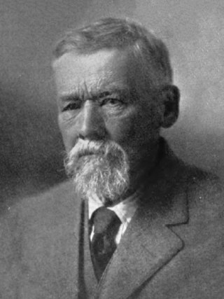
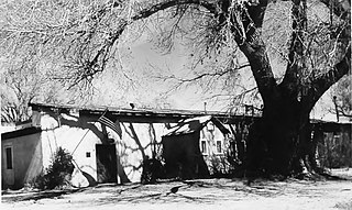
John Horton Slaughter, also known as Texas John Slaughter, was an American lawman, cowboy, poker player and rancher in the Southwestern United States during the late 19th and early 20th centuries. After serving in the Confederate States Army during the American Civil War, Slaughter earned a reputation fighting hostile Indians and Mexican and American outlaws in the Arizona and New Mexico territories. In the latter half of his life, he lived at the San Bernardino Ranch, which is today a well-preserved National Historic Landmark in Cochise County in far southeastern Arizona. In 1964, he was inducted into the Hall of Great Westerners of the National Cowboy & Western Heritage Museum.

Malpai Borderlands is a land area along the U.S.-Mexico border. It encompasses the southeast corner of Arizona and the southwest corner of New Mexico. It is sometimes defined as including areas in the Mexican states of Chihuahua and Sonora. The Malpai is part of the Madrean Region which includes the arid and semi-arid borderlands of the United States and Mexico from California to Texas.

The Yaqui sucker is a species of ray-finned fish in the family Catostomidae. It is found in the Aridoamerica region of northern Mexico and south-western United States. Catostomus bernardini or Yaqui sucker belongs to the family Catostomidae. The Yaqui sucker is related to the Sonora sucker and could possibly be a subspecies of the Gila sucker.

The beautiful shiner is a species of ray-finned fish in the family Cyprinidae. It is found in Mexico and Arizona and New Mexico in the United States. It is one of 22 species of Cyprinella found in North America.

The Yaqui chub is a species of freshwater fish in the family Cyprinidae. It is found in northern Mexico and the United States. The Yaqui chub is a medium-sized minnow fish that historically occurred in streams of Rios Matape, Sonora, and the Yaqui systems of Sonora, Mexico. It is one of the five species of the genus Gila in Arizona. The Yaqui chub is closely related to G. ditaenia, and G. orcutti ; and shares several physical characteristics with the G. orcutti, but proves different by having a black wedge near the base of the caudal fin.

Ictalurus pricei, the Yaqui catfish, is a species of North American freshwater catfish native to Mexico and Arizona.
The Sierra Bonita Ranch, founded in 1872 by Henry C. Hooker, is one of the oldest cattle ranches in the United States and the ranch buildings have been designated a National Historic Landmark. It was the first permanent American cattle ranch in Arizona. Hooker bought neighboring ranches until his operation became the largest ranch in Arizona, totaling 800 square miles (2,100 km2), or about 30 by 27 miles. It is located in Sulphur Springs Valley about 27 miles (43 km) north of present-day Willcox, Arizona. The modern ranch is much smaller but is still operational and owned by Jesse Hooker Davis, the sixth generation to live and work on the ranch.
Hereford is a populated place in Cochise County along the San Pedro Riparian National Conservation Area in the southern part of the U.S. state of Arizona. It is southeast of Sierra Vista and is a part of the Sierra Vista-Douglas micropolitan area. The elevation is 4,193 feet at the location of the original townsite at the far eastern end of the unincorporated area; the residential area runs for another 8 miles west from this location, blending into the unincorporated area of Nicksville at an elevation of approximately 4800 feet. Hereford Station Post Office is located at the far western end of Nicksville, at the foot of the Huachuca Mountains.
The Rio San Bernardino, or San Bernardino River, begins in extreme southeastern Cochise County, Arizona, and is a tributary of the Bavispe River, in Sonora, Mexico.

The San Bernardino National Wildlife Refuge is located on the U.S.-Mexico border in Cochise County, Arizona. Situated at 3,720 to 3,920 feet (1,130–1,190 m) elevation in the bottom of a wide valley, the refuge encompasses a portion of the headwaters of the Yaqui River, which drains primarily western Chihuahua and eastern Sonora, Mexico. The 2,309-acre (9.34 km2) ranch was acquired by the U.S. Fish and Wildlife Service in 1982 to protect the water resources and provide habitat for endangered native fishes.

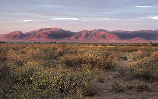
The San Bernardino Valley of Arizona is a 35 mi (56 km) northeast-by-southwest trending valley in extreme southeast Cochise County, Arizona. The north end of the valley merges into the northwest-by-southeast trending San Simon Valley; both merge in western perimeter Hidaldgo County, New Mexico. The valley is an asymmetric graben.

Presidio San Agustín del Tucsón was a presidio located within Tucson, Arizona, United States. The original fortress was built by Spanish soldiers during the 18th century and was the founding structure of what became the city of Tucson. After the American arrival in 1846, the original walls were dismantled, with the last section torn down in 1918. A reconstruction of the northeast corner of the fort was completed in 2007 following an archaeological excavation that located the fort's northeast tower.

The Little Boquillas Ranch is an historic ranch property located in western Cochise County, Arizona, near the Fairbank Historic Townsite in what is now part of the San Pedro Riparian National Conservation Area.
Whitewater Draw, originally Rio de Agua Prieta, [Spanish: river of dark water], is a tributary stream of the Rio de Agua Prieta in Cochise County, Arizona. It was called Blackwater Creek by Philip St. George Cooke when his command, the Mormon Battalion, camped at a spring on its course on December 5, 1846.
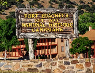
This is a list with images of some of the historic structures and places in the Fort Huachuca National Historic District in Arizona. The district, also known as Old Fort Huachuca, is located within Fort Huachuca an active United States Army installation under the command of the United States Army Installation Management Command. The fort sits at the base of the Huachuca Mountains four miles west of the town of Sierra Vista, on AZ 90 in Cochise County, Arizona.